

Early Evening Update
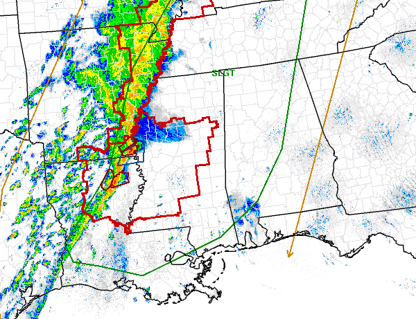
As a strong cold front marches east, showers and thunderstorms continue to develop and move with it. A strong line of showers and some severe thunderstorms are pushing east this evening. Much of Central Mississippi remains under a tornado watch until 11 PM. There are a few severe thunderstorm and tornado warning with this line. We expect severe weather watches to be issued eastward as the storm system continues its movement.
RISK AREA: Much of Alabama remains in a slight risk for severe weather until 7 AM. The risk runs along a line from near Scottsboro in Jackson County, to Gadsden, Pell City, Clanton, Selma, Monroeville and Citronelle in northern Mobile County. All of Birmingham, Tuscaloosa, Cullman, Fayette, Hamilton and Demoplis are in this risk.
FORCING: The surface low with this system has remained in Iowa, Illinois and the Great Lakes today. For a classic severe weather event, the surface low would need to be farther south over Arkansas, southern Missouri or northern Mississippi. That helps add dynamics and increase winds shear across Alabama. For this event, that is not the case. The main lifting mechanism is the front itself. It is doing a great job at allowing thunderstorms to develop, but it is lacking some other key severe weather parameters that are needed.
INSTABILITY: Many areas warmed into the 80s today and dew points have remained in the lower 60s. The low level jet could increase over the region this evening, but daytime heating will be lost. CAPE values for Central Alabama look to remain around 500 J/KG, with maybe some slightly higher values over northwest Alabama. This will help provide enough energy for thunderstorm development tonight.
TIMING: This has remained constant through the day. Storms should be approaching the western boarder of Alabama just before midnight. For the Birmingham metro, it looks as though 3-4 AM will be the time that things could get a little rough. By sunrise the line should be approaching our eastern boarder. The thunderstorm timing will be slower the farther south and east you go. Storms could still be ongoing through late morning tomorrow down towards Troy and Phenix City.
THREATS: It would appear that a strong squall line will be crossing the state. With most squall lines, damaging straight line winds will be the main concern. With the main forcing of the system so far to the north, it is hard to get strongly rotating thunderstorm. However, tornadoes will still be a threat, especially in any bowing segment along the line. These are very hard to detect a lot of times because that are rain wrapped and many times in the intense radar returns.
BE SAFE: Since the worst of the activity will be impacting the state during the overnight hours, it is essential that you have a way to receive severe weather alerts. You cannot rely on outdoor weather sirens. Make sure you have multiple sources for severe weather notifications that will wake you up when you are being threatened.
Category: Alabama's Weather, Severe Weather
About the Author (Author Profile)
Macon, Georgia Television Chief Meteorologist, Birmingham native, and long time Contributor on AlabamaWX. Stormchaser. I did not choose Weather, it chose Me. College Football Fanatic. @Ryan_StinnetSubscribe
If you enjoyed this article, subscribe to receive more just like it.


