

Severe Weather Threatens Alabama Late Tonight
**No afternoon Weather Xtreme video today… I am in Pell City, where we are programming NOAA Weather radio receivers at the Publix through 6:30 p.m. If you need help, come see us**
QUIET FOR NOW: Nothing on the radar across Alabama this afternoon… we have a mix of sun and clouds with temperatures in the 80s.
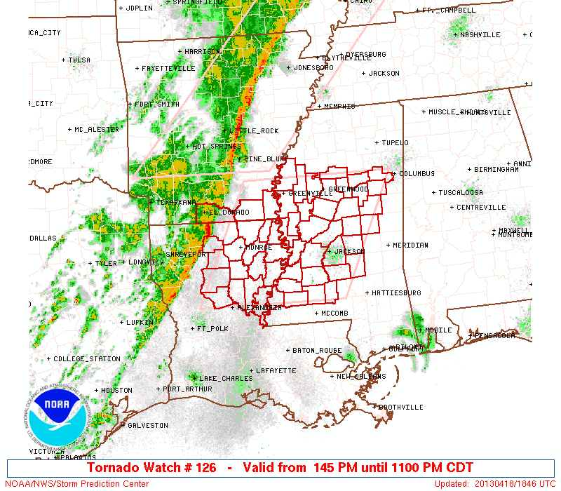
TO THE WEST: A tornado watch is up for much of Central Mississippi until 11:00 p.m. CT…
THE ALABAMA SEVERE WEATHER THREAT: We have made a few adjustments, but the overall idea is the same for tonight and early tomorrow…
*Storms should enter Northwest Alabama late tonight, as early as 11:00 p.m. The primary severe weather threat for Alabama will come from midnight until 6:00 a.m. Storms should weaken below severe limits toward daybreak as they move into East Alabama.
Below is the HRRR model output valid at 1:00 a.m…

*SPC has removed the “moderate risk”… we now have the standard “slight risk” of severe weather for that part of Alabama west of a line from Scottsboro to Montgomery to Chatom. Anniston and Gadsden are not in the risk… but most of Central and West Alabama are in it.

*The highest risk of a tornado will come over Northwest Alabama… counties like Lauderdale, Colbert, Marion, Lamar, Lawrence, Franklin and Winston. The primary threat will come from damaging straight line winds along the squall line, but understand a few isolated tornadoes are possible as far east as I-65 during the pre-dawn hours. The severe weather risk for East Alabama is much lower.

As always, the greatest risk of a tornado will come from discrete cells ahead of the main squall line, but a spin-up tornado is possible within the line itself.
*We note the HRRR is a little more aggressive with the instability (surface based CAPE) late tonight ahead of the storms… CAPE values are over 1,000 j/kg

This will provide an environment supportive of strong to severe storms, despite the late night/early morning time frame.
*Rain amounts of 1/2 to 1 inch can be expected… major flooding issues are not expected.
*Please have a good, properly programmed NOAA Weather Radio in your home late tonight so you won’t miss any warnings… NEVER rely on an outdoor warning siren to let you know a tornado is coming. That is extremely dangerous. A good smart phone app like MyWarn or iMap WeatherRadio is a great source of warnings on the go.
*The rain will end from west to east tomorrow morning, and most all of the rain should be out of Alabama by late morning. Tomorrow will be cooler with a high in the 60s.
FROST ALERT FOR EARLY SATURDAY: Models are trending colder, and I think they are correct. It now looks like most places across North/Central Alabama are headed for the mid to upper 30s at daybreak Saturday, and some scattered, light frost is possible, especially in valleys and protected areas. Growers need to be aware of that…
The rest of the weekend will be delightful… lots of sunshine Saturday with a high in the upper 60s. More sunshine Sunday with a high in the low 70s.
NEXT WEEK: Still looks like the next organized round of showers and storms will come on Wednesday… too early to determine if there will be a severe weather issue.
WEATHER BRAINS: Don’t forget you can listen to our weekly 90 minute netcast anytime on the web, or on iTunes. This is the show all about weather featuring many familiar voices, including our meteorologists here at ABC 33/40.
CONNECT: You can find me on all of the major social networks…
We will have the blog updated often tonight and early tomorrow as this severe weather event unfolds… stay tuned…
Category: Alabama's Weather
About the Author (Author Profile)
James Spann is one of the most recognized and trusted television meteorologists in the industry. He holds the AMS CCM designation and television seals from the AMS and NWA. He is a past winner of the Broadcast Meteorologist of the Year from both professional organizations.Subscribe
If you enjoyed this article, subscribe to receive more just like it.


