

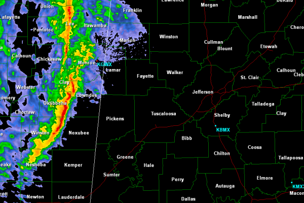
Storms Approaching the State Line
Thunderstorms are getting ready to cross the state line and make their way into West Alabama. None of these storms are currently severe, but a few of them are strong. Areas form Pickens through Lamar and Marion Counties will begin to see the rain fall shortly. Some lightning, gusty winds and small hail may accompany these storms.
Storms are right on time, 10-11 PM was mentioned all day for storms to enter the state. These storms will continue to move east and should be to Fayette and Jasper around midnight. Birmingham and the Interstate 65 corridor around the 2-3 AM time frame. Areas in east Alabama 4-6 AM.
Main threat with the storms tonight will be damaging winds. There could be an isolated severe thunderstorm and even an isolated tornado still cannot be ruled out. The greatest chance for severe weather is over portions of our northwestern counties. Instability and shear values have really come down through the evening. Storms overall should continue to weaken overnight.
Many areas will see a soaking rain overnight.
Category: Alabama's Weather, Severe Weather
About the Author (Author Profile)
Macon, Georgia Television Chief Meteorologist, Birmingham native, and long time Contributor on AlabamaWX. Stormchaser. I did not choose Weather, it chose Me. College Football Fanatic. @Ryan_StinnetSubscribe
If you enjoyed this article, subscribe to receive more just like it.


