

Warmer Days Ahead
An all new edition of the ABC 33/40 Weather Xtreme video is available in the player on the right sidebar of the blog. You can subscribe to the Weather Xtreme video on iTunes by clicking here.
BRIGHTER AND WARMER: The average high for May 7 in Birmingham is 79 degrees… the Birmingham Airport reports 66 degrees at 2:00, so we still have a long way to go, but at least we are moving in the right direction after record cool weather in recent days.
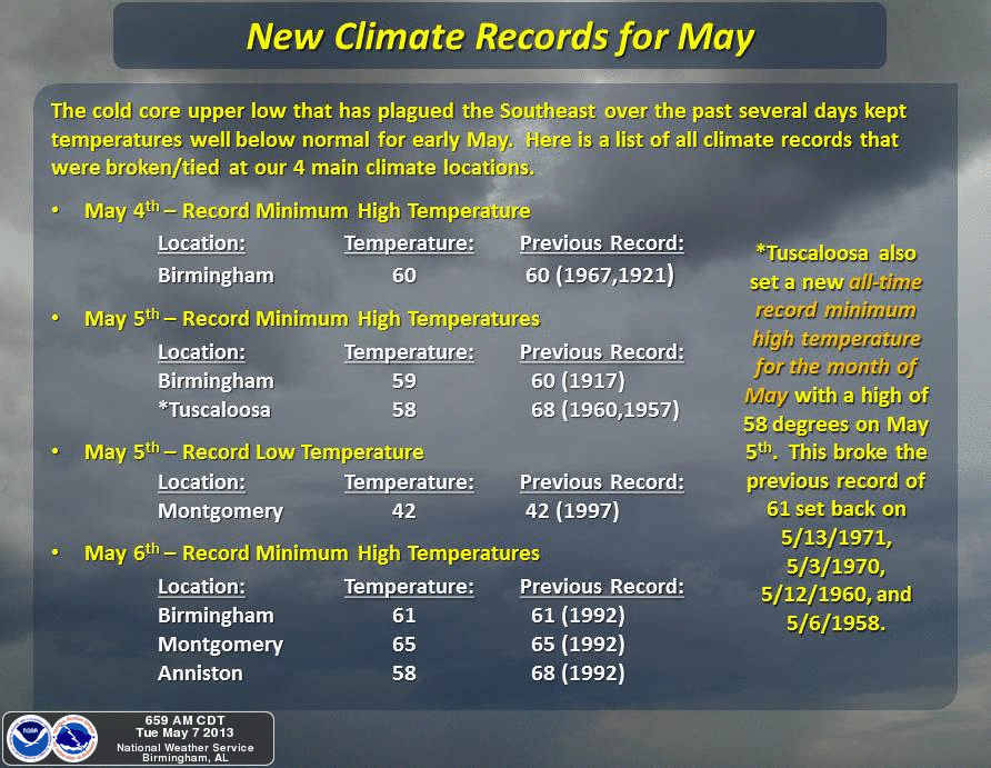
This graphic from the Birmingham NWS tells the story of the May chill well…
Nothing on the radar as of 3:30… but we will hang on to a slight risk of a shower near the Tennessee Valley for the next few hours.
TOMORROW/THURSDAY: The warm-up continues, with a high tomorrow near 80, followed by mid 80s Thursday. It will finally feel like May. We note the NAM continues to show some potential for isolated showers tomorrow afternoon during the peak of the daytime heating process, and we will continue to mention that in the forecast. Thursday should be dry with a good supply of sunshine.
SHOWERS RETURN LATE IN THE WEEK: Moisture increases Friday, and we will need to mention some risk of a shower Friday afternoon and Friday night, with the best chance coming west and north of Birmingham. A good chance we see low 80s Friday afternoon with a mix of sun and clouds.
WET START TO THE WEEKEND: Not much change in the overall thinking for the weekend. We will forecast periods of rain Saturday, along with the possibility of a thunderstorm with an upper system lifting out of the Southwest U.S., and the approach of a cold front from the north. While we can’t give you start/stop times, just be aware the rain could come at any hour of the day or night Saturday. No severe weather, and rain totals should be around 1/2 inch.
New model data confirms the showers should end late Saturday night, or very early Sunday morning during the pre-dawn hours. The sky should clear Sunday morning as cooler and drier air blows into the state. The high Sunday afternoon will be in the low 70s with a cool north breeze.
ANOTHER MAY CHILL EARLY NEXT WEEK: Sure looks like we drop well down into the 40s both Monday and Tuesday morning of next week, and it is very possible some of the normally colder spots could reach the upper 30s, something that rarely happens in mid-May in Alabama. Monday and Tuesday should feature brilliant sunshine with a high in the upper 60s Monday, followed by mid 70s Tuesday. Some record lows could be in danger Monday and Tuesday morning as the winter of 2012-13 just won’t give up.
See the Weather Xtreme video for maps, graphics, and details.
WEATHER BRAINS: Don’t forget you can listen to our weekly 90 minute netcast anytime on the web, or on iTunes. This is the show all about weather featuring many familiar voices, including our meteorologists here at ABC 33/40. Scroll down for the show notes on the new episode we recorded last week.
CONNECT: You can find me on all of the major social networks…
Facebook
Twitter
Google Plus
Instagram
I had a great time today visiting the first graders at Hayden Primary School in Blount County… be looking for them on the Pepsi KIDCAM today at 5:00 on ABC 33/40 News! The next Weather Xtreme video will be posted here by 7:00 a.m. tomorrow…
Category: Alabama's Weather
About the Author (Author Profile)
James Spann is one of the most recognized and trusted television meteorologists in the industry. He holds the AMS CCM designation and television seals from the AMS and NWA. He is a past winner of the Broadcast Meteorologist of the Year from both professional organizations.Subscribe
If you enjoyed this article, subscribe to receive more just like it.


