Large Tornado Moving into Cleburne TX
The storm we have been tracking for over an hour across southern parts of the Dallas Metroplex has produced a lot of damage and injuries tonight.
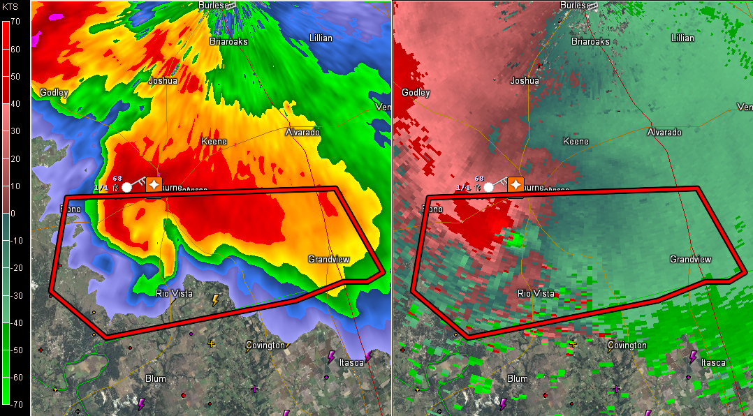
Now a tornado is moving north into the city of Cleburne. Warge, wedge tornado confirmed by spotters. Strong indications of debris on Doppler radar.
From the NWS Fort Worth:
FWD issues Tornado Warning for Johnson [TX] till 9:45 PM CDT …AT 923 PM CDT…STORM SPOTTERS AND DOPPLER RADAR OBSERVED A TORNADO NEAR CLEBURNE…MOVING NORTHEAST AT 15 MPH. SPOTTERS REPORTED THAT THIS IS A MILE WIDE TORNADO…CAPABLE OF INCREDIBLE DESTRUCTION. THIS TORNADO HAS SHIFTED ITS TRACK AND WAS MOVING NORTH RIGHT AT THE CITY OF CLEBURNE! IF YOU ARE IN ITS PATH…TAKE COVER IMMEDIATELY TO PROTECT YOUR LIFE!
80 mph winds confirmed at the hospital there.
The tornado appeared to be moving south of Cleburne, but it suddenly turned north up TX-171 and it moving into the city of Cleburne.
The good news is that the circulation appears to be weakening and a new circulation will likely form to the south, to the north of Rio Vista.
Category: Headlines, Severe Weather
About the Author (Author Profile)
Bill Murray is the President of The Weather Factory. He is the site's official weather historian and a weekend forecaster. He also anchors the site's severe weather coverage. Bill Murray is the proud holder of National Weather Association Digital Seal #0001 @wxhistorianSubscribe
If you enjoyed this article, subscribe to receive more just like it.


