Scattered Flooding Issues
An all new edition of the ABC 33/40 Weather Xtreme video is available in the player on the right sidebar of the blog. You can subscribe to the Weather Xtreme video on iTunes by clicking here.
HIT AND MISS: Storms are scattered across Alabama this afternoon… Tuscaloosa reports sunshine at mid-afternoon with 90 degrees, while Birmingham had a tropical downpour with road flooding and temperatures in the low 70s. Flash flood warnings are up for parts of Jefferson and St. Clair counties; earlier Blount County was under a flash flood warning. The storms are moving slowly to the east/north, and some spots have received over 4 inches of rain directly under the heavier, slow moving downpours.
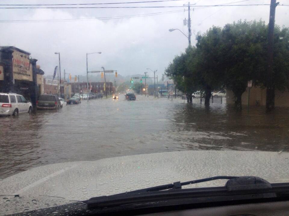
Below is a look at flooding on 24th Street South in Birmingham (at 3 p.m.)… from @heathwill
The B’ham Airport has measured over three inches of rain since 2:30 (3.01″ as I write this).
TOMORROW/FRIDAY: An axis of deep, tropical moisture stays in place, so we will continue to forecast scattered to numerous showers and storms both days. Like today, some spots could see heavy rain; highs will be in the low to mid 80s and the sky will be generally cloudy.
WATCHING THE GULF: **Update… NHC will upgrade the system in the Gulf to Tropical Storm Andrea within the hour*
Andrea will move slowly northeast, and the RPM model puts the center into the coast near Apalachicola, Florida tomorrow evening. Very rough surf and dangerous rip tides all along the Gulf Coast, and very heavy rain east of the low pressure center. The heaviest rain directly from the tropical low will come from the Florida Peninsula… and up the East Coast of the U.S.
BEACH BOUND? The most widespread rain will come from Destin and Panama City eastward tomorrow… while showers will be more scattered at Gulf Shores and Pensacola. Again we stress dangerous rip tides are likely all along the Central Gulf tomorrow. Then, for Friday and the weekend, about 6 to 8 hours of sunshine each day with a few scattered showers or storms (typical for June). Highs hold in the 80s… and water temperatures are generally near 80 degrees.
OUR WEEKEND: Drier air drops into the state, and we should be mostly dry (the northern half of Alabama) Saturday and Sunday with only a slight risk of a shower. Highs will be in the mid to upper 80s over the weekend.
Next week we expect the hottest weather so far this year with low 90s likely Monday through Wednesday… showers should be few and far between thanks to an upper high overhead. See the Weather Xtreme video for the maps, graphics, and details.
WEATHER BRAINS: Don’t forget you can listen to our weekly 90 minute netcast anytime on the web, or on iTunes. This is the show all about weather featuring many familiar voices, including our meteorologists here at ABC 33/40.
CONNECT: You can find me on all of the major social networks…
Facebook
Twitter
Google Plus
Instagram
Look for the next Weather Xtreme video here by 7:00 a.m. tomorrow…
Category: Alabama's Weather
About the Author (Author Profile)
James Spann is one of the most recognized and trusted television meteorologists in the industry. He holds the AMS CCM designation and television seals from the AMS and NWA. He is a past winner of the Broadcast Meteorologist of the Year from both professional organizations.Subscribe
If you enjoyed this article, subscribe to receive more just like it.


