Quick Radar Check
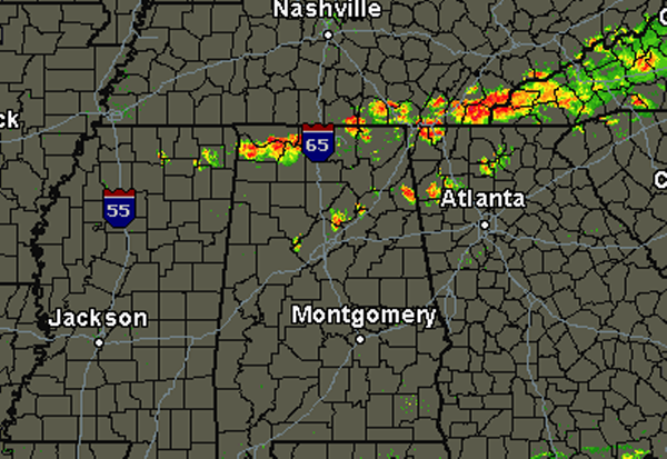
A line of storms has developed across the Tennessee Valley and it pushing south. None of these storms are currently severe, but they are producing gusty winds, heavy rain and frequent lightning. These storms will continue to push off towards the south and should track across much of Alabama this evening and into the overnight hours.
There have been a few thunderstorms develop over Central Alabama. One was located in western Jefferson County, another in eastern Jefferson County moving east into St. Clair county and a fairly strong storm over Cherokee County. We can expect some more thunderstorms to develop over the next few hours. The main line of storms look to be affecting Birmingham between 6-7 this evening.
A chance for severe weather remains until the front passes through your location. The SPC maintains a slight risk for severe weather over much of Alabama through tonight. Main threat will remain the chance for damaging straight line winds. Some hail and a very isolated tornado may be possible as well. Once the line pushes through, conditions will be improving overnight and into the weekend.
Category: Alabama's Weather
About the Author (Author Profile)
Macon, Georgia Television Chief Meteorologist, Birmingham native, and long time Contributor on AlabamaWX. Stormchaser. I did not choose Weather, it chose Me. College Football Fanatic. @Ryan_StinnetSubscribe
If you enjoyed this article, subscribe to receive more just like it.


