

Lunchtime Update
Showers have continued to develop during the morning hours across Central Alabama. This activity is developing out ahead of frontal boundary that is across the Tennessee Valley and continues to drop south across the state. Luckily, most of the activity is just showers with only a few reports of thunder so far today. That could change heading through out the afternoon as daytime heating could lead to greater instability across the state. Storms should remain below severe limits, but it is possible to get an isolated severe storm today that could produce some hail and damaging winds.
Currently, the most intense showers stretch from eastern Jefferson County back to the west to Walker, Fayette, and Lamar Counties. The band of showers will continue to move east-southeast over the next few hours. The showers are producing very intense rain. Also a band of showers in the Tennessee Valley along the frontal boundary itself and storms down towards the Interstate 85 corridor.
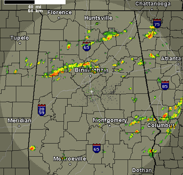
For the rest of the afternoon, the very warm, muggy and soupy air mass will still allow for additional showers and thunderstorms to develop. All activity will be makings its way southeastwards ahead of the frontal boundary. Behind the frontal boundary conditions will improve later this evening and tonight and it looks as though most everyone will get a chance to dry out the next few days.
Category: Alabama's Weather
About the Author (Author Profile)
Macon, Georgia Television Chief Meteorologist, Birmingham native, and long time Contributor on AlabamaWX. Stormchaser. I did not choose Weather, it chose Me. College Football Fanatic. @Ryan_StinnetSubscribe
If you enjoyed this article, subscribe to receive more just like it.


