

Showers and Some Strong Storms
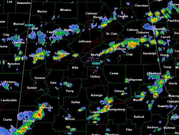
Showers and storms continue to develop and intensify some over central Alabama this afternoon. No storms are currently severe, but several of them are strong, producing gusty winds, intense rain and frequent lightning.
Several bands of convective activity have developed and continue to push east-southeast ahead of the front boundary that will be bringing drier air into the state the next few days. Until it clears the area, showers and storms will continue to affect many areas.
Some of the more intense activity is in Marengo County as well as just south of Interstate 20 east of Birmingham affecting areas around Talladega, Clay and Cleburne Counties. Back to the west of Birmingham, a pretty descent thunderstorm was across northeastern Tuscaloosa County near Brookwood and Vance as well as eastern Pickens County near Gordo.
The back edge of the rain appears to be making it to certain areas. A line from Sulligent, Jasper, Cullman, Oneonta, Gadsden and Centre and points to the north and west are seeing much less activity and appear to be finally getting a chance to dry out.
Category: Alabama's Weather
About the Author (Author Profile)
Macon, Georgia Television Chief Meteorologist, Birmingham native, and long time Contributor on AlabamaWX. Stormchaser. I did not choose Weather, it chose Me. College Football Fanatic. @Ryan_StinnetSubscribe
If you enjoyed this article, subscribe to receive more just like it.


