

An Active Radar this Afternoon
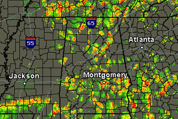
This afternoon is certainly starting off with an active radar across much of Alabama. Abundant moisture in the atmosphere is providing ample fuel for showers and thunderstorms across the state.
As expected today, this convection is more widespread than what we saw on Saturday, and will continue to expand through out the afternoon. Storms today will be producing torrential rain as well as frequent lightning. In some of the stronger cells, gusty winds and hail may be observed. The main concern today will certainly be a threat for some localized flash flooding.
Some of the more intense activity currently is affecting several areas across Central Alabama. Portions of Marion, Jefferson, St. Clair, Etowah, Pickens, Montgomery, Macon and Bullock Counties. Today storm motion is to the east-northeast. The radar will be very busy the rest of the afternoon and showers and storms will last through the evening hours.
Category: Alabama's Weather
About the Author (Author Profile)
Macon, Georgia Television Chief Meteorologist, Birmingham native, and long time Contributor on AlabamaWX. Stormchaser. I did not choose Weather, it chose Me. College Football Fanatic. @Ryan_StinnetSubscribe
If you enjoyed this article, subscribe to receive more just like it.


