

Severe Thunderstorm Warning Greene/Hale/Marengo/Perry/Sumter

LATE REPORT FROM TERRY SASSER (GARDENDALE/FULTONDALE)
Another 1.35″ total for today with rain slacking off. That now puts me right at 7″ since Saturday evening. I got it everyday. Amazing. Winds here were only 10 – 14 mph and no hail. A good bit of C-G lightning.
ORIGINAL POST
Thunderstorms over West Central Alabama are intensifying as they move into more unstable air. Instability values are running 2500-3500 j/kg ahead of the line. This area did not have storms this morning so instability is very high. These storms have dropped south on Interstate 20/59 and will be impacting Highways 69, 25, 43 and 80. Demopolis, Greensboro, Newbern, Marion, Livingston and Linden will be impacted by these storms.
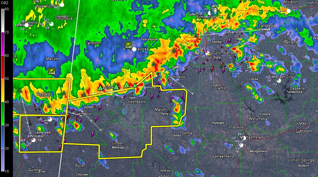
These storms are capable of producing winds of 60 mph or higher. This can bring down trees. There are some indications of small hail as well, especially north of Greensboro. Cloud tops are over 50,000 feet high in that area.
They are also producing copious amounts of lightning and torrential rains. One hour rainfall rates will exceed two inches per hour in the heavier downpours, which can produce flash flooding quickly.
Storms are forming ahead of the main squall line now over southern Talladega and Coosa Counties generally from Childersburg to Goodwater.
Others are forming ahead of the line in Marengo, Perry and moving into southwestern Chilton Counties.
THE NATIONAL WEATHER SERVICE IN BIRMINGHAM HAS ISSUED A
* SEVERE THUNDERSTORM WARNING FOR…
SOUTHERN GREENE COUNTY IN WEST CENTRAL ALABAMA…
HALE COUNTY IN WEST CENTRAL ALABAMA…
NORTHERN MARENGO COUNTY IN SOUTHWEST ALABAMA…
PERRY COUNTY IN ALABAMA…
SUMTER COUNTY IN WEST CENTRAL ALABAMA…
* UNTIL 300 PM CDT
* AT 156 PM CDT…THE NATIONAL WEATHER SERVICE INDICATED A LINE OF
SEVERE THUNDERSTORMS CAPABLE OF PRODUCING DAMAGING WINDS IN EXCESS
OF 60 MPH. THESE STORMS WERE LOCATED ALONG A LINE EXTENDING FROM
LOW GAP TO 8 MILES NORTH OF GREENSBORO TO WEDGEWORTH TO EPES TO
EMELLE…AND MOVING SOUTHEAST AT 45 MPH.
* LOCATIONS IMPACTED INCLUDE…
CUBA…YORK…LIVINGSTON…GREENSBORO…MARION…DEMOPOLIS…
UNIONTOWN AND LINDEN.
THIS INCLUDES…
INTERSTATE 20 EXIT NUMBERS 1 THROUGH 23…
WINDS OF 60 TO 70 MPH WILL BREAK LARGE TREE LIMBS AND CAUSE SOME
DAMAGE…ESPECIALLY TO SMALLER STRUCTURES.
PRECAUTIONARY/PREPAREDNESS ACTIONS…
FOR YOUR PROTECTION…MOVE TO AN INTERIOR ROOM ON THE LOWEST FLOOR OF
YOUR HOME OR BUSINESS.
Category: Alabama's Weather, Severe Weather
About the Author (Author Profile)
Subscribe
If you enjoyed this article, subscribe to receive more just like it.


