Flash Flood Watch Cullman County

The Tennessee Valley of Alabama has been placed under a flash flood watch from now through Thursday morning. Across portions of the Valley this morning, very heavy rain has been falling and has contributed to flash flooding in Marshall and Madison Counties. Other areas are beginning to see showers and storms as well and the flooding threat is expected to increase.
Additional showers and storms will continue to move in from the northwest over the next few days as pesky northwest flow keeps unsettled weather flowing into Alabama. With saturated grounds from an abundance of rain lately and the expected additional rainfall, the NWS in Huntsville has issued this flash flood watch.
I would not be surprised to see additional flood advisories issued for portions of Central Alabama as well. Always remember to never drive through flooded roadways, TURN AROUND, DON’T DROWN.
 FLASH FLOOD WATCH IN EFFECT THROUGH THURSDAY MORNING...
THE NATIONAL WEATHER SERVICE IN HUNTSVILLE HAS ISSUED A
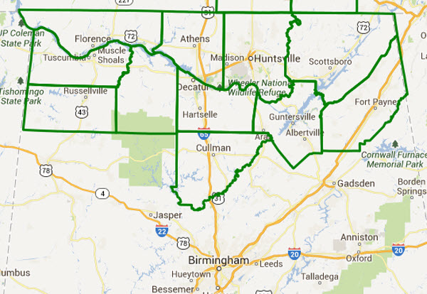
* FLASH FLOOD WATCH FOR PORTIONS OF ALABAMA AND SOUTHERN MIDDLE
TENNESSEE...INCLUDING THE FOLLOWING AREAS...IN ALABAMA...
COLBERT...CULLMAN...DEKALB...FRANKLIN AL...JACKSON...
LAUDERDALE...LAWRENCE...LIMESTONE...MADISON...MARSHALL AND MORGAN.
IN SOUTHERN MIDDLE TENNESSEE...FRANKLIN TN...LINCOLN AND MOORE.
* THROUGH THURSDAY MORNING
* SEVERAL EPISODES OF SHOWERS AND THUNDERSTORMS ARE EXPECTED TO
IMPACT THE WARNING AREA THROUGH THURSDAY MORNING. THE RAINFALL IS
NOT EXPECTED TO BE CONTINUOUS...AND BREAKS IN THE PRECIPITATION
WILL ALLOW FOR SOME RECOVERY BETWEEN THE CLUSTERS OF SHOWERS AND
STORMS. HOWEVER...TORRENTIAL RAINFALL IS ANTICIPATED WITH EACH
ROUND OF PRECIPITATION AND THIS COMBINED WITH SATURATED SOIL
CONDITIONS WILL MAKE CONDITIONS VERY FAVORABLE FOR FLASH FLOODING.
* FLASH FLOODING WILL LEAD TO RAPID RISES ON AREA CREEKS AND
TRIBUTARIES...AND RESULT IN SIGNIFICANT PONDING OF WATER ON AREA
ROADS.
PRECAUTIONARY/PREPAREDNESS ACTIONS...
A FLASH FLOOD WATCH MEANS THAT CONDITIONS MAY DEVELOP THAT LEAD TO
FLASH FLOODING. FLASH FLOODING IS A VERY DANGEROUS SITUATION.
YOU SHOULD MONITOR LATER FORECASTS AND BE PREPARED TO TAKE ACTION
SHOULD FLASH FLOOD WARNINGS BE ISSUED.
FLASH FLOOD WATCH IN EFFECT THROUGH THURSDAY MORNING...

THE NATIONAL WEATHER SERVICE IN HUNTSVILLE HAS ISSUED A

* FLASH FLOOD WATCH FOR PORTIONS OF ALABAMA AND SOUTHERN MIDDLE
  TENNESSEE...INCLUDING THE FOLLOWING AREAS...IN ALABAMA...
  COLBERT...CULLMAN...DEKALB...FRANKLIN AL...JACKSON...
  LAUDERDALE...LAWRENCE...LIMESTONE...MADISON...MARSHALL AND MORGAN.
  IN SOUTHERN MIDDLE TENNESSEE...FRANKLIN TN...LINCOLN AND MOORE.

* THROUGH THURSDAY MORNING

* SEVERAL EPISODES OF SHOWERS AND THUNDERSTORMS ARE EXPECTED TO
  IMPACT THE WARNING AREA THROUGH THURSDAY MORNING. THE RAINFALL IS
  NOT EXPECTED TO BE CONTINUOUS...AND BREAKS IN THE PRECIPITATION
  WILL ALLOW FOR SOME RECOVERY BETWEEN THE CLUSTERS OF SHOWERS AND
  STORMS. HOWEVER...TORRENTIAL RAINFALL IS ANTICIPATED WITH EACH
  ROUND OF PRECIPITATION AND THIS COMBINED WITH SATURATED SOIL
  CONDITIONS WILL MAKE CONDITIONS VERY FAVORABLE FOR FLASH FLOODING.

* FLASH FLOODING WILL LEAD TO RAPID RISES ON AREA CREEKS AND
  TRIBUTARIES...AND RESULT IN SIGNIFICANT PONDING OF WATER ON AREA
  ROADS.

PRECAUTIONARY/PREPAREDNESS ACTIONS...

A FLASH FLOOD WATCH MEANS THAT CONDITIONS MAY DEVELOP THAT LEAD TO
FLASH FLOODING. FLASH FLOODING IS A VERY DANGEROUS SITUATION.

YOU SHOULD MONITOR LATER FORECASTS AND BE PREPARED TO TAKE ACTION
SHOULD FLASH FLOOD WARNINGS BE ISSUED.Category: Alabama's Weather, Severe Weather
About the Author (Author Profile)
Macon, Georgia Television Chief Meteorologist, Birmingham native, and long time Contributor on AlabamaWX. Stormchaser. I did not choose Weather, it chose Me. College Football Fanatic. @Ryan_StinnetSubscribe
If you enjoyed this article, subscribe to receive more just like it.


