Watching Karen Closely
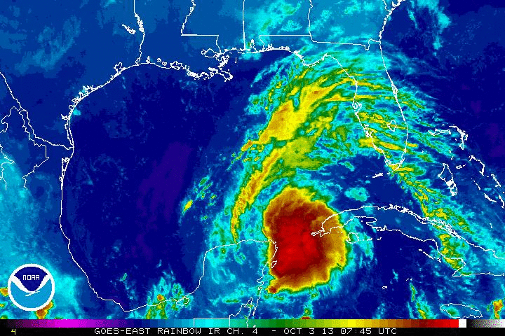
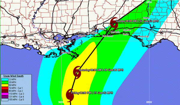
The main weather story for folks along the Gulf Coast and in the Southeast is newly formed Tropical Storm Karen. Karen will impact the Gulf Coast over the weekend as a strong tropical storm. Expect gusty winds and torrential tropical downpours with this system as she moves onshore. The worst of the weather associated with Karen should be along and east of where the center of the system makes landfall.
According to the current model tracks, that should keep much of central Alabama from seeing the worst of this storm. There is still a lot of time for things to change, but current thinking has Karen making landfall near the Alabama/Florida state line sometime late Saturday or early Sunday. She is expected to continue a northeast track as a cold front sweeping into the region will draw her in that direction.
Over the last few hours, the cloud tops have been warming and that could signal that intensification has slowed. Karen is interacting with some wind shear over the Gulf today and that could be taking a bit of a toll on her. However, gradual strengthening is expected over the next 48 hours and actually the NHC has Karen making it to hurricane strength, but weakening some before landfall. We are watching this system closely as it will be impacting portions of Alabama.
Category: Alabama's Weather, Tropical
About the Author (Author Profile)
Macon, Georgia Television Chief Meteorologist, Birmingham native, and long time Contributor on AlabamaWX. Stormchaser. I did not choose Weather, it chose Me. College Football Fanatic. @Ryan_StinnetSubscribe
If you enjoyed this article, subscribe to receive more just like it.


