Update on Karen
Karen continues to move NNW across the southern Gulf of Mexico this afternoon. The system is still packing a punch with sustained winds of 65 MPH, but throughout the day, the system seems less organized and appears to be weakening.
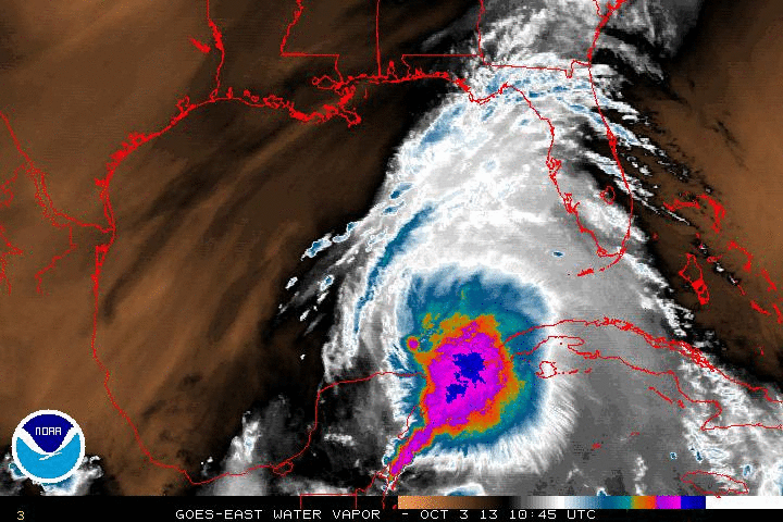
The Hurricane Hunters are currently flying through the storm and it should be interesting what they find on this trip. Looking at the water vapor loop, there is a lot of dry air around the system and some of that dry air could be getting ingested into the system. That will hamper intensification of the system.
We still expect Karen to move towards the North Central Gulf Coast and landfall is expected overnight Saturday. The NHC still thinks the system will reach hurricane strength, but it is expected to weaken before landfall along the Alabama or Northwest Florida Coast.
LOCATION…22.9N 88.2W
ABOUT 430 MI…695 KM S OF THE MOUTH OF THE MISSISSIPPI RIVER
MAXIMUM SUSTAINED WINDS…65 MPH…100 KM/H
PRESENT MOVEMENT…NNW OR 330 DEGREES AT 12 MPH…19 KM/H
MINIMUM CENTRAL PRESSURE…1004 MB…29.65 INCHES
Category: Alabama's Weather, Tropical
About the Author (Author Profile)
Macon, Georgia Television Chief Meteorologist, Birmingham native, and long time Contributor on AlabamaWX. Stormchaser. I did not choose Weather, it chose Me. College Football Fanatic. @Ryan_StinnetSubscribe
If you enjoyed this article, subscribe to receive more just like it.


