Karen Moving North In The Gulf
An all new edition of the ABC 33/40 Weather Xtreme video is available in the player on the right sidebar of the blog. You can subscribe to the Weather Xtreme video on iTunes by clicking here.
RIGHT NOW: Pretty quiet weather across Alabama this afternoon as expected; there have been a few isolated showers today over West Alabama, but there is nothing showing up at mid-afternoon. Temperatures are mostly in the 78-83 degree range with a mix of sun and clouds.
TONIGHT AND TOMORROW: While the chance of rain is not zero, any showers should be isolated. The high tomorrow will be in the low to mid 80s, and there is only a slight risk of a shower for high school football games tonight and tomorrow night. Most stadiums will be rain-free with temperatures in the 70s.
TROPICAL STORM KAREN AND OUR WEEKEND: Let’s go through the important points of our weekend forecast, and an update on newly formed Tropical Storm Karen in the Gulf of Mexico…
KAREN NOW: Karen is packing sustained winds of 65 mph in the southern Gulf of Mexico. It is moving north/northwest at 12 mph.
TRACK: NHC’s official track brings the center of Tropical Storm Karen into the Gulf Coast around Orange Beach, AL, or Pensacola, FL Saturday night. There is pretty decent model agreement on this. The worst of the weather in terms of wind and rain will be along and east of the landfall point.
INTENSITY: I honestly think Karen has already peaked in intensity. It will be fighting dry air, cooler SSTs (sea surface temperatures), and shear due to the approaching mid-latitude upper trough. I figure Karen will have maximum sustained winds of 40-50 mph at the time of landfall. Yes, NHC has a hurricane watch in effect for the Central Gulf Coast, but that should be replaced by a tropical storm warning tomorrow morning.
COASTAL IMPACT: Rain amounts of over 5 inches are possible from Dauphin Island and Gulf Shores west to near Navarre Beach, FL; this could create some flooding problems. Also, dangerous rip currents are likely from the Alabama Gulf Coast west to near Panama City through Saturday, and as Karen approaches the coast there is some risk of a few small, isolated tornadoes in the spiral bands east of the circulation center. The heaviest rain on the coast will come from about 9:00 a.m. Saturday through 9:00 a.m. Sunday; conditions should improve greatly by Sunday afternoon. Next week looks delightful on the coast with sunny pleasant days and clear cool nights.
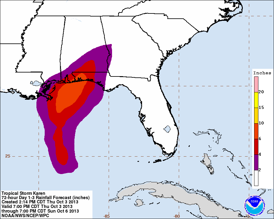
NORTH/CENTRAL ALABAMA: Most of the day Saturday will be dry, although a few widely scattered showers are not out of the question. The rain shield will impact mostly Southwest Alabama Saturday afternoon. The primary threat of rain for North/Central Alabama will come from about 8:00 p.m. Saturday through 8:00 p.m. Sunday. For places like Tuscaloosa, Birmingham, Anniston, and Gadsden, we project rain amounts of 1/2 to 1 inch, with potential for a little more in a few places.
The heaviest rain in Alabama should come south of a line from Chatom to Camden to Montgomery to Alexander City to Roanoke; below this line rain amounts of 1 to 2 inches are likely, with isolated totals to 3 inches.
The chance of isolated tornadoes is very, very small for the northern half of the state since the air will be rather stable Sunday.
FOOTBALL WEATHER: For the Alabama/Georgia State game at Bryant-Denny Stadium Saturday (11:21a CT kickoff), clouds will increase, but for now we will mention only an outside risk of a brief shower during the game (best chance of widespread rain comes after the final whistle). Around 80 at kickoff, with low 80s possible by the second half.
Auburn will host Ole Miss at Jordan-Hare Stadium Saturday evening (6:00p CT kickoff); I feel more optimistic about the weather for this game, although you still need to take the rain gear as showers will be possible. But, there is pretty good model agreement now that the heavy, widespread rain will come into the Auburn/Opelika area after the game is over later Saturday night. It will be cloudy and breezy during the game with temperatures in the 70s.
UAB has a home game against Florida Atlantic (2:00p CT kickoff) at Legion Field; the sky will be cloudy, and for now the risk of really significant rain looks rather small, although a brief shower is certainly possible. Temperatures will be in the low 80s at kickoff.
NEXT WEEK: Cool, dry air will be the story, and I still believe we reach the 40s early Tuesday morning. Looks like all of next week will feature very refreshing autumn weather.
WEATHER BRAINS: Don’t forget you can listen to our weekly 90 minute netcast anytime on the web, or on iTunes. This is the show all about weather featuring many familiar voices, including our meteorologists here at ABC 33/40.
CONNECT: You can find me on all of the major social networks…
Facebook
Twitter
Google Plus
Instagram
Look for the next Weather Xtreme video here by 7:00 a.m. tomorrow….
Category: Alabama's Weather
About the Author (Author Profile)
James Spann is one of the most recognized and trusted television meteorologists in the industry. He holds the AMS CCM designation and television seals from the AMS and NWA. He is a past winner of the Broadcast Meteorologist of the Year from both professional organizations.Subscribe
If you enjoyed this article, subscribe to receive more just like it.


