10 p.m. Update on Karen
FAST FACTS AS OF 10 PM
———————————————–
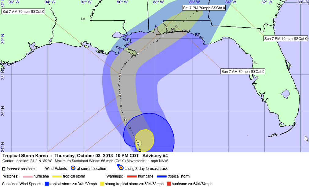
LOCATION…24.2N 89.0W
ABOUT 450 MILES SSW OF MOBILE
MAXIMUM SUSTAINED WINDS…65 MPH…100 KM/H
PRESENT MOVEMENT…NNW OR 335 DEGREES AT 10 MPH…17 KM/H
MINIMUM CENTRAL PRESSURE…999 MB…29.50 INCHES
Some subtle changes in the 10 p.m. forecast for Karen.
The track is shifted ever so slightly to the right.
It now looks like it won’t become a hurricane.
The graphic shows the “skinny black line” (actually dotted) of the official track forecast, which we should remember can be off by a significant amount.
The brighter blue around the center of the tropical storm is the extent of the tropical storm force winds >= 39 mph). The brighter yellow area shows the extent of the strong tropical storm force winds (>= 58 mph).
Notice that the strong winds are almost all on the right side of the storm. That is usually the case, but not to the extent that we see in Karen, which is a moderately sheared storm. That shear will steadily increase over the next couple of days, resulting in a gradual weakening of the storm.
The ribbon of yellow indicates the forecasted extent of strong tropical storm force winds with the blue ribbon surrounding it showing the predicted extent of tropical storm force winds.
Category: Tropical
About the Author (Author Profile)
Bill Murray is the President of The Weather Factory. He is the site's official weather historian and a weekend forecaster. He also anchors the site's severe weather coverage. Bill Murray is the proud holder of National Weather Association Digital Seal #0001 @wxhistorianSubscribe
If you enjoyed this article, subscribe to receive more just like it.


