Tropical Storm Karen Getting Closer
An all new edition of the ABC 33/40 Weather Xtreme video is available in the player on the right sidebar of the blog. You can subscribe to the Weather Xtreme video on iTunes by clicking here.
STILL QUIET THROUGH TOMORROW: The weather over the northern half of Alabama won’t change much today; a mix of sun and clouds with only a small risk of any one community seeing a shower this afternoon or tonight. The high will be in the low to mid 80s. Most high school football stadiums will be dry tonight with temperatures in the 70s; the best chance of isolated showers this evening will be on the western side of the state.
WEEKEND RAIN: Alabama will be dealing with two significant weather features this weekend… a cold front approaching from the northwest, supported by a vigorous mid-latitude upper trough, and Tropical Storm Karen approaching from the south. Karen’s behavior will determine the real timing and extent of the rain.
KAREN THIS MORNING/INTENSITY: The system is not well organized. Most of the convection is displaced to the east of the storm circulation center, meaning their is wind shear impacting the system. Also, dry air is over the western part of the circulation, and it is encountering cooler sea surface temperatures. Like I stated here yesterday, I do expect Karen to stay below hurricane strength, and I think the intensity peaked yesterday morning.
TRACK: The center of Karen will clip the mouth of the Mississippi River at Plaquemines Parish tomorrow night, and then it moves inland around Mobile Bay early Sunday morning. Models have trended a little slower, and NHC has adjusted their forecast accordingly. The circulation center will then move northeast across South Alabama during the day Sunday. The greatest chance of heavy rain, flooding, and isolated tornadoes will be along the east of the circulation center.
COASTAL IMPACT: Rain amounts of 2 to 4 inches are possible from Dauphin Island, Gulf Shores, and east to Destin and Panama City. The bulk of the heavy, widespread rain for the coast will come from about 12:00 noon Saturday until 12:00 noon Sunday… but a few passing showers and storms are possible at anytime today and tonight as the initial feeder bands associated with Karen move inland. Also, a few isolated, small tornadoes will be possible on the coast as Karen moves inland. The weather will improve on the coast Sunday afternoon, and next week looks beautiful with sunny pleasant days and clear cool nights.
INLAND PARTS OF ALABAMA: We continue to be confident that most of the day tomorrow will be dry, with only widely scattered showers over the northern half of the state. The sun could peek out at times, and temperatures should rise into the low 80s. The bulk of the rain will come on Sunday; rain amounts of around one inch are likely for our part of Alabama (cities like Birmingham, Tuscaloosa, Anniston, and Gadsden), with the heaviest rain to the south and east.
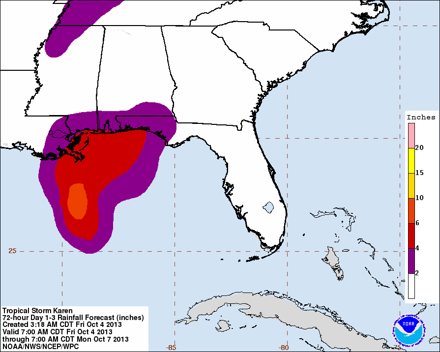
But, we caution you that trying to identify the axis of the heaviest rain with a tropical storm like Karen, that is somewhat disorganized, and be difficult. Below is the WPC graphic showing where over two inches of rain is expected (colors in purple)…
FOOTBALL WEATHER: For the Alabama/Georgia State game at Bryant-Denny Stadium tomorrow (11:21a CT kickoff), expect a mix of sun and clouds with only a small risk of a shower during the game. About 80 at kickoff, with low 80s by the fourth quarter.
Auburn will host Ole Miss at Jordan-Hare Stadium tomorrow evening (6:00p CT kickoff); with the slower track of Karen it sure looks like rain won’t be a big issue. A brief, passing shower is possible, but the game should be played generally with dry conditions. Temperatures will fall slowly through the mid to upper 70s, and there will be a gusty south breeze of 10-15 mph.
UAB has a home game against Florida Atlantic tomorrow (2:00p CT kickoff) at Legion Field; the sky will be partly sunny with only a slight risk of a shower. We project 82 degrees at kickoff, and upper 70s by the final whistle.
NEXT WEEK: Cool, dry air will be the story, and I still believe we reach the 40s early Tuesday morning. Looks like all of next week will feature very refreshing autumn weather.
ON THIS DATE IN 1995: Hurricane Opal slammed into the western Florida Panhandle near Pensacola with maximum sustained winds of 115 mph. Mary Esther, Florida recorded sustained winds of 80 mph with a questionable wind gust report to 144 mph. Although winds were diminishing at the time of landfall, extensive damage due to a storm surge of 15 feet and breaking waves occurred over most of the coastal areas of the Florida panhandle. The U.S. death toll was nine. Total damage was $3 billion. Extensive flooding and power outages followed Opal as it moved north through East Alabama.
WEATHER BRAINS: Don’t forget you can listen to our weekly 90 minute netcast anytime on the web, or on iTunes. This is the show all about weather featuring many familiar voices, including our meteorologists here at ABC 33/40.
CONNECT: You can find me on all of the major social networks…
Facebook
Twitter
Google Plus
Instagram
I will be doing a weather program this morning at Helena Middle School…. look for the next Weather Xtreme video here by 4:00 this afternoon. Enjoy the day!
Category: Alabama's Weather
About the Author (Author Profile)
James Spann is one of the most recognized and trusted television meteorologists in the industry. He holds the AMS CCM designation and television seals from the AMS and NWA. He is a past winner of the Broadcast Meteorologist of the Year from both professional organizations.Subscribe
If you enjoyed this article, subscribe to receive more just like it.


