Warm Tomorrow; Storms Thursday Night
An all new edition of the ABC 33/40 Weather Xtreme video is available in the player on the right sidebar of the blog. You can subscribe to the Weather Xtreme video on iTunes by clicking here.
ALMOST NOVEMBER: Funny how some people think November and December should be consistently cold in Alabama. Never has, and never will in this low latitude state. November is famous for big weather swings, when you go from 80 degrees one day to 20s two days later, with big storms during the change. November and December are the months in our fall tornado season, which can be just as volatile as spring.
The next few days will bring a good example of what we expect around here this time of the year.
WARM TOMORROW: We stay rain-free tomorrow with a mix of sun and clouds, and a high near 80 degrees. This is ten degrees above average for late October; the record high tomorrow (October 30) in Birmingham is 86 degrees, set in 1984… we won’t expect it to be that warm.
LATE WEEK STORMS: The day Thursday will be dry, but breezy thanks to a storm system getting closer to Alabama. Thunderstorms are likely Thursday night into Friday morning; here is our thinking on the system…
TIMING: Thunderstorms could enter the northwest corner of the state in the 4:00-6:00 p.m. time frame, up around Florence and Muscle Shoals. For places like Tuscaloosa, Birmingham, Anniston, and Gadsden, the rain should begin around 7:00. Below is high resolution model output valid at 7:00 pm CT Thursday (from the 4km NAM)…
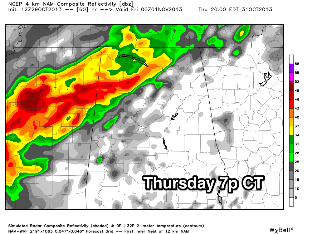
Please understand this is just model output, and the time the rain begins in your neighborhood could change. Keep an eye on blog discussions tomorrow for updates.
SEVERE STORMS? SPC maintains the standard “slight risk” of severe weather for Northwest Alabama tomorrow night. No doubt severe storms are possible over West Tennessee, Northwest Mississippi, and North Louisiana Thursday afternoon, where a tornado or two is possible with a robust combination of shear and instability. Severe weather in Alabama is possible mainly northwest of a line from Millport to Haleyville to Athens… the main threat will come from strong straight line winds with storms in that part of the state Thursday evening.
We believe the storms will slowly weaken as they move southeast, and for now the severe weather threat for Birmingham, Tuscaloosa, Anniston, and Gadsden is pretty marginal with very low surface based instability values and weakening shear.
HOW MUCH RAIN? Rain amounts of one to one and a half inches are likely over most of Alabama; not enough for any really serious flooding issues.
WHEN DOES IT END? The rain will end from west to east during the midday hours Friday, and all of the rain will be gone by the time high school football games begins Friday night as cooler and drier air moves into the state.
See the Weather Xtreme video for the maps, graphics, and details.
OUR WEEKEND: Cool and dry weather is the story with sunny days and clear, chilly nights. Highs will be in the 60s, and we will drop to near 40 early Sunday, with 30s for the colder valleys and protected areas.
NEXT WEEK: The next storm system will bring showers and storms back to Alabama Wednesday, and those could be pretty strong. Too early to determine if severe weather will be an issue.
TROPICS: All remains quiet, and tropical storm formation is not expected this week across the Atlantic basin.
WEATHER BRAINS: Don’t forget you can listen to our weekly 90 minute netcast anytime on the web, or on iTunes. This is the show all about weather featuring many familiar voices, including our meteorologists here at ABC 33/40. Scroll down for the show notes on the new episode recorded last night.
CONNECT: You can find me on all of the major social networks…
Facebook
Twitter
Google Plus
Instagram
I had a great time today visiting the kids at Episcopal Day School in Gadsden… be looking for them on the Pepsi KIDCAM today at 5:00 on ABC 33/40 News! The next Weather Xtreme video will be posted here by 7:00 a.m. tomorrow….
Category: Alabama's Weather
About the Author (Author Profile)
James Spann is one of the most recognized and trusted television meteorologists in the industry. He holds the AMS CCM designation and television seals from the AMS and NWA. He is a past winner of the Broadcast Meteorologist of the Year from both professional organizations.Subscribe
If you enjoyed this article, subscribe to receive more just like it.


