Storm System Getting Closer
An all new edition of the ABC 33/40 Weather Xtreme video is available in the player on the right sidebar of the blog. You can subscribe to the Weather Xtreme video on iTunes by clicking here.
MILD OCTOBER DAY: Temperatures are not quite warm as forecast across the northern half of Alabama this afternoon, but we are still seeing mid to upper 70s, well above our average high of 70 degrees for October 30. Clouds have steadily increased over the past few hours, but there is no rain across our state.
THUNDERSTORMS ON THE WAY: Not much change in our overall thinking with the approaching storm system. We note the NWS in Huntsville has issued a wind advisory for their counties up in the Tennessee Valley for tomorrow and tomorrow night due to a tight pressure gradient; winds in that part of Alabama will average 12-25 mph, with gusts to 30.
TIMING: Showers and storms will enter extreme Northwest Alabama tomorrow afternoon; places like Millport, Vernon, Hamilton, Russellville, and Florence will have rain at times during the afternoon hours, but the rest of the state will be dry during the day with breezy and mild conditions.
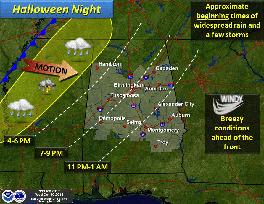
Showers and storms will move down into the Birmingham, Tuscaloosa, Anniston, and Gadsden areas in the 6:00 to 8:00 p.m. time frame. See the approximate “rain start” times on the graphic below from the NWS in Birmingham…
The best chance of rain-free trick or treating will be for areas south and east of Birmingham tomorrow evening.
SEVERE WEATHER THREAT: SPC maintains the standard “slight risk” of severe weather for Northwest Alabama tomorrow evening. The risk is along and west of a line from Reform to Smith Lake to Scottsboro.
Severe storms will develop across the Mid-South tomorrow afternoon, impacting places like Jackson, MS, Memphis, TN, and Paducah, KY. Severe weather parameters are highest from near Greenville, MS north to Paducah, and this is where SPC has an enhanced 30 percent risk of severe weather within 25 miles of a given point. This is your classic “high shear, low CAPE” event; instability values are very marginal, but shear values would suggest that storms could rotate easily. I expect a few tornado warnings in this region tomorrow afternoon.
HERE IN ALABAMA: Storms could be severe as they move into the northwest part of the state late tomorrow… the main threat will come from strong straight line winds, but we can’t rule out an isolated tornado over the northwest corner of Alabama. Then, the storms should weaken as they move south tomorrow night, and the severe weather risk looks rather low for Birmingham, Tuscaloosa, Anniston, and Gadsden where there is very little surface based instability.
Of course, with thunderstorms we expect the unexpected, so we will watch radar trends closely. Be sure and see the afternoon Weather Xtreme video for the maps, graphics, and details.
HEAVY RAIN POTENTIAL: The NWS in Jackson has issued a flash flood watch for much of Mississippi… here in Alabama it looks like rain totals of 1 to 2 inches will be likely. Don’t think we will have any serious flood issues here since it has been dry lately, but the rain will be heavy at times.
FRIDAY: The rain will end Friday morning, and the sky will clear Friday night as cooler and drier moves into Alabama. No rain for the high school football games Friday night; the sky will be clear with temperatures falling through the 50s.
OUR WEEKEND: We will forecast a sun filled sky Saturday and Sunday; the high Saturday will be in the mid 60s, with low 60s Sunday. The low early Sunday will be near 40 degrees, with 30s for the colder pockets.
FOOTBALL WEATHER: Auburn plays at Arkansas Saturday (5:00pm CT kickoff); the sky will be sunny with a kickoff temperature near 55 degrees, falling quickly into the 40s by halftime. UAB will host Middle Tennessee State Saturday at Legion Field in Birmingham (12:00pm CT kickoff); the sky will be sunny. About 62 degrees at kickoff, 65 degrees by the final whistle with a stiff north wind of 10-20 mph.
NEXT WEEK: The next round of showers and storms is due in here late Wednesday, Wednesday night, into Thursday morning of next week. That system will also have to monitored for severe weather potential; see the Weather Xtreme video for details.
WEATHER BRAINS: Don’t forget you can listen to our weekly 90 minute netcast anytime on the web, or on iTunes. This is the show all about weather featuring many familiar voices, including our meteorologists here at ABC 33/40.
CONNECT: You can find me on all of the major social networks…
Facebook
Twitter
Google Plus
Instagram
I had a great time today visiting with the 6th graders at Berry Middle School in Hoover, and the kindergarten students at Walnut Park Elementary in Gadsden. They will be on the Pepsi KIDCAM this evening on ABC 33/40 News at 5:00 and 6:00. Look for the next Weather Xtreme video here by 7:00 a.m. tomorrow….
Category: Alabama's Weather
About the Author (Author Profile)
James Spann is one of the most recognized and trusted television meteorologists in the industry. He holds the AMS CCM designation and television seals from the AMS and NWA. He is a past winner of the Broadcast Meteorologist of the Year from both professional organizations.Subscribe
If you enjoyed this article, subscribe to receive more just like it.


