Rain Creeps Into Northwest Alabama
An all new edition of the ABC 33/40 Weather Xtreme video is available in the player on the right sidebar of the blog. You can subscribe to the Weather Xtreme video on iTunes by clicking here.
RADAR CHECK: Some light rain is falling early this morning over the northern third of Alabama ahead of a major storm system approaching from the west. Some of what you see is not reaching the ground, but it is raining at places like Muscle Shoals and Russellville. Also a few sprinkles around Huntsville, Decatur, and Athens.
DAYTIME HOURS: Birmingham, Tuscaloosa, Anniston, and Gadsden will remain generally dry during the day, with a gusty south wind developing this afternoon as the pressure gradient tightens. Rain is possible over the far western and northern counties, however. The sky will be cloudy and the high today will be in the low to mid 70s.
Heavier rain moves into Alabama tonight, not exactly what you want to see Halloween night. Here are the talking points on tonight’s event…
TIMING: Below is the high resolution NAM model (4km) valid at 7:00 CT tonight… the heaviest rain is just northwest of I-59…
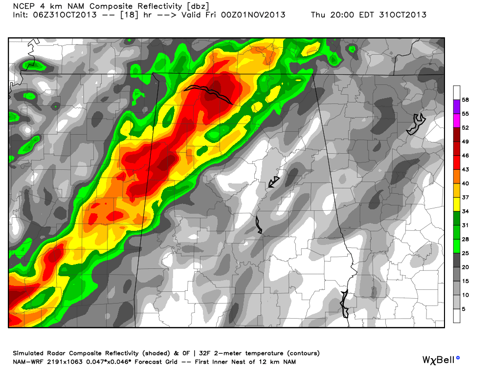
This, of course, doesn’t the rain will be in that exact position; this is just model output. Sure looks like the really significant rain will begin for places like Birmingham, Tuscaloosa, Anniston, and Gadsden in the 6:00 to 8:00 p.m. time frame.
Best chance of dry trick or treating will come for communities south and east of Birmingham.
SEVERE WEATHER THREAT: SPC maintains the standard “slight risk” of severe weather for this evening along and west of a line from Huntsville to Tuscaloosa to Butler. So far, the amount of severe weather with this system has been unimpressive, and with very little surface based instability, the overall severe weather threat for Alabama still looks pretty low.
Still, over Northwest Alabama late today there is a good low level jet (winds of over 60 knots at 850 mb, or around 5,000 feet), and low level shear values are high (HRRR model shows 0-1 km shear in excess of 50 knots). We will keep an eye on the storms as they move into the state as they could produce gusty winds, but they should weaken as they move deeper into Alabama tonight.
We should note that SPC does not have any part of Alabama in a tornado threat, they define a 2 percent tornado probability (within 25 miles of a given point) for areas just west of here.
RAIN AMOUNTS: Rain totals of around one inch are likely for most Alabama communities, with some spots getting up to 1.5 inches. Not enough for flash flooding, most likely. We do note the NWS in Jackson maintains a flash flood watch for parts of Central Mississippi, where amounts could be heavier.
Take a few minutes to watch the Weather Xtreme video for a more detailed briefing, and a look at all of the maps and graphics.
TOMORROW: Models are now showing the rain ending pretty early in the day; the rain could end in the Birmingham metro by 7:00 a.m. The sky will begin to clear tomorrow afternoon as drier and cooler air blows in here. The weather looks great for high school football games tomorrow night with a clear sky and cool temperatures, falling through the 50s.
FOOTBALL WEATHER: Auburn plays at Arkansas Saturday (5:00pm CT kickoff); the sky will be sunny with a kickoff temperature near 55 degrees, falling quickly into the 40s by halftime. UAB will host Middle Tennessee State Saturday at Legion Field in Birmingham (12:00pm CT kickoff); the sky will be sunny. About 62 degrees at kickoff, 65 degrees by the final whistle with a stiff north wind of 10-20 mph.
NEXT WEEK: The 00Z GFS shows the next round of showers and storms coming in here Wednesday night or Thursday of next week; it looks very similar to the system we will deal with tonight. Not much instability, but pretty decent dynamics.
WEATHER BRAINS: Don’t forget you can listen to our weekly 90 minute netcast anytime on the web, or on iTunes. This is the show all about weather featuring many familiar voices, including our meteorologists here at ABC 33/40.
CONNECT: You can find me on all of the major social networks…
Facebook
Twitter
Google Plus
Instagram
I will be doing a weather program this morning at Walker Elementary School in Tuscaloosa County… be looking for the next Weather Xtreme video here by 4:00 this afternoon. Enjoy the day!
Category: Alabama's Weather
About the Author (Author Profile)
James Spann is one of the most recognized and trusted television meteorologists in the industry. He holds the AMS CCM designation and television seals from the AMS and NWA. He is a past winner of the Broadcast Meteorologist of the Year from both professional organizations.Subscribe
If you enjoyed this article, subscribe to receive more just like it.


