

Morning Notes
Some late morning notes on Alabama weather on this November Sunday:
…Today is the 11th anniversary of the Veterans Day Weekend Tornado Outbreak that saw 11 tornadoes in Alabama on Sunday afternoon and evening. They killed 12 people. They are part of a three day severe weather outbreak that produced 79 tornadoes from Arkansas, Mississippi and Alabama as far east as South Carolina northward to Ohio and Pennsylvania. The tornadoes killed 36 people and injured over 300. There were 800 total severe weather reports.
…Nothing like that today though. Skies are clearing quickly in the wake of an upper level disturbance that is over South Carolina now. Regional radars detect some light showers in eastern Georgia south of Augusta, and perhaps a few weakening ones in southeastern Arkansas, where there is a little residual upper level moisture. Our airmass is drying out and this trend should continue through the rest of the day. I can’t find any reason to leave any light showers in the forecast for any part of the area this afternoon.
…Temperatures are climbing quickly through the 60s heading toward highs in the upper 60s. A few folks will hit 70F today with the increasing sunshine.
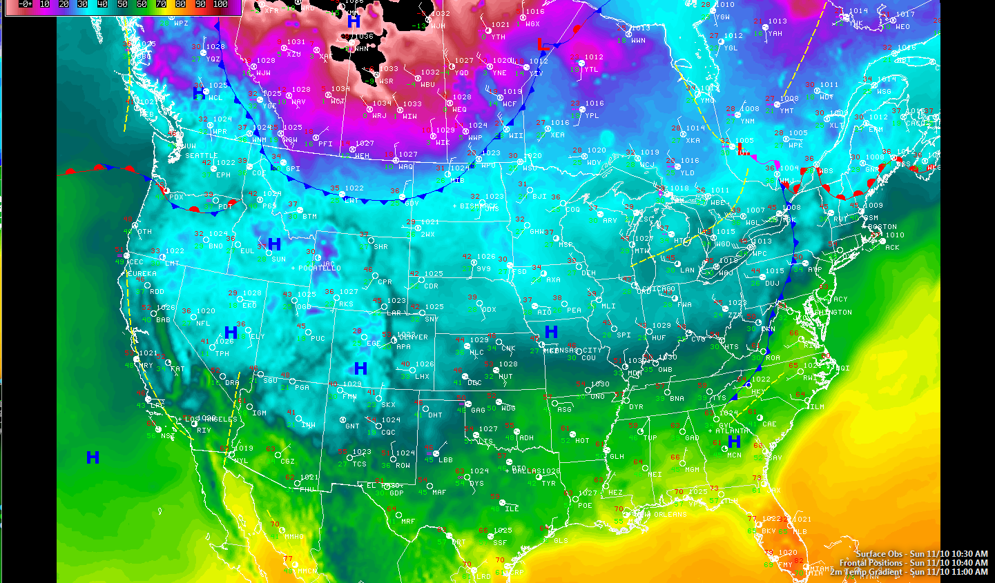
…High pressure resides over the Mississippi Valley this morning with centers near Kansas City and near Monroe, Louisiana.
Click to enlarge image.
…Our next weathermaker, an Arctic front, has entered the northern Plains and was approaching Billings, Bismarck and Fargo. Temperatures well below zero cover much of Alberta, Saskatchewan and Manitoba. It was -4F last hour at Jimmy Lake, SK. The front is being driven south by a massive 1035 mb high straddling the border between the Canadian provinces of Alberta and Saskatchewan. Winter storm warnings are in effect above 5,000 feet in the Rockies Mountains in Montana where 6-12 inches of snow are expected through tonight.
…We should have nice weather here tomorrow ahead of that Arctic front, now projected to arrive in Northwest Alabama by 8 p.m. tomorrow night, reaching the I-59 corridor before sunrise Tuesday. The front will be accompanied by biting northerly winds and falling temperatures within a few hours of its passage. In the I-59 corridor, highs should reach the middle and upper 50s by late morning, with falling readings after that. There will be some clouds and a few showers from a weakening band of precipitation on Tuesday afternoon, adding a little insult to injury.
…It will be cold. Expect middle and upper 20s Wednesday morning with lower and middle 20s Thursday morning. Most folks will be below freezing still Friday morning as a gradual moderating trend begins. Highs Wednesday won’t get out of the 40s and Thursday highs won’t be much better, in the middle 5os. 60s should return Friday.
…Sneaking ahead to next weekend. There is pretty good agreement between the morning run of the GFS and last night’s European that we will deal with a decent rainfall event next Sunday and Monday. 1 to 3 inches of rain look possible. We could use it.
…Looking in the record bin: only one item to report today. The high at South Lake Tahoe CA reached 63F yesterday, tying the old record for the date.
Category: Alabama's Weather, Headlines
About the Author (Author Profile)
Bill Murray is the President of The Weather Factory. He is the site's official weather historian and a weekend forecaster. He also anchors the site's severe weather coverage. Bill Murray is the proud holder of National Weather Association Digital Seal #0001 @wxhistorianSubscribe
If you enjoyed this article, subscribe to receive more just like it.


