Arctic Air Arrives Tomorrow Night
An all new edition of the ABC 33/40 Weather Xtreme video is available in the player on the right sidebar of the blog. You can subscribe to the Weather Xtreme video on iTunes by clicking here.
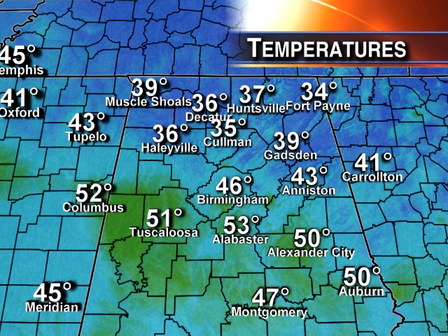
ONE MORE MILD DAY: Early morning temperatures across Alabama show why this really isn’t a “one number” kind of place when forecasting temperatures. We have almost a twenty degree spread from 34 at Fort Payne to 53 at the Shelby County Airport, just south of Birmingham…
We warm nicely today, and most communities see a high between 67 and 70 degrees this afternoon with a partly to mostly sunny sky.
NOVEMBER BLAST OF COLD AIR: A quick hitting early season cold snap is the headline this week. The cold front passes through here tomorrow morning, and winds will increase during the day, averaging 15-25 mph out of the northwest with occasional gusts to 30 mph. Looks like temperatures will fall over the northern half of the state; our high in the mid 50s should come during the late morning or midday hours, after that we drop into the 40s tomorrow afternoon, and those harsh northwest winds will make it feel colder.
We will have a mix of sun and clouds, and while a sprinkle or two is possible over the northeast corner of the state, most of Alabama will be dry as the cold air blows in.
INTO THE 20s: We are projecting lows in the 24 to 29 degree range early Wednesday and Thursday morning, way below our average low of 42. Here are the records based on data at the Birmingham Airport…
November 13 22 (1911)
November 14 24 (1986)
While I don’t expect Birmingham’s official observation to be quite that low, no doubt the colder pockets over North Alabama will see low 20s.
Despite sunshine in full supply Wednesday, I don’t think temperatures will get out of the 40s unless you are south of Birmingham. It will be more like mid-January instead of mid-November.
THURSDAY/FRIDAY: We begin to warm up Thursday afternoon with a high in the mid 50s along with a sunny sky, and low 60s are likely Friday. We will begin to see some clouds returning Friday thanks to an increase in low level moisture.
THE ALABAMA WEEKEND: I guess a little light rain will be possible Saturday in scattered spots with a decent amount of moisture in place, but there is not much dynamic support for rain, and the high resolution ECMWF looks pretty dry. The sky Saturday will be occasionally cloudy, and the weather will be comfortable with a high in the mid to upper 60s.
Showers are more likely Sunday, but even then it doesn’t look really heavy, or especially widespread. A decent chance we see a high near 70 degrees Sunday afternoon.
See the Weather Xtreme video for the maps, graphics, and details.
WEATHER BRAINS: Don’t forget you can listen to our weekly 90 minute netcast anytime on the web, or on iTunes. This is the show all about weather featuring many familiar voices, including our meteorologists here at ABC 33/40. We will produce this week’s show tonight at 8:30 p.m. CT… you can watch it on “James Spann 24/7” on cable systems around the state, or on the web here.
CONNECT: You can find me on all of the major social networks…
Facebook
Twitter
Google Plus
Instagram
Look for the next Weather Xtreme video here by 4:00 this afternoon…. enjoy the day…
Category: Alabama's Weather
About the Author (Author Profile)
James Spann is one of the most recognized and trusted television meteorologists in the industry. He holds the AMS CCM designation and television seals from the AMS and NWA. He is a past winner of the Broadcast Meteorologist of the Year from both professional organizations.Subscribe
If you enjoyed this article, subscribe to receive more just like it.


