Warming Trend Begins This Afternoon
An all new edition of the ABC 33/40 Weather Xtreme video is available in the player on the right sidebar of the blog. You can subscribe to the Weather Xtreme video on iTunes by clicking here.
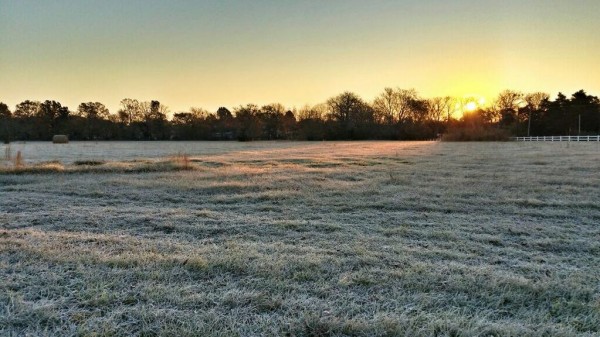
FRIGID AIR: Still too cold for November. A peek at temperatures just before sunrise…
Black Creek (just northeast of Gadsden) 16
Gadsden 19
Valley Head 19
Sycamore 19
Morris 20
Eastaboga 20
Fort Payne 21
Russellville 21
Coker 22
Fultondale 22
Bessemer 23
Haleyville 23
Chelsea 23
Pleasant Grove 24
Fayette 24
Jemison 27
Tuscaloosa 27
Birmingham 28
(frosty photo this morning from @mswxphotog)
No record for Birmingham… the low of 28 is 4 degrees warmer than the record low of 24 set in 1986.
WARMING TREND BEGINS LATER TODAY: With sunshine in full supply today, we expect a high in the mid to upper 50s this afternoon.
SHOWERS POSSIBLE TOMORROW: Moist air returns to Alabama tomorrow, and with short wave energy approaching from the west, we will need to insert a chance of showers in tomorrow’s forecast. The rain won’t be too widespread or heavy, but no doubt you might get wet a time or two if you are outdoors. Heavier rain totals tomorrow should come over the southern half of the state, otherwise the day will be mostly cloudy with a high in the low 60s.
OUR WEEKEND: Saturday sure looks like a pretty decent day, as Friday’s wave moves on to the east. I can’t totally rule out a shower in isolated spots, but most communities should be dry with a mix of sun and clouds and a high very close to 70 degrees as our warm-up continues.
Showers should form during the day Sunday with rising moisture levels and an approaching cold front. SPC maintains a risk of severe weather sunday from near Memphis to Cleveland, but the chance of severe weather in Alabama Sunday night looks low with hardly any surface based instability, and with the better dynamics well to the north of here. See the Weather Xtreme video for the maps, graphics, and details.
The 06Z GFS hints the showers and storms will end late Sunday night, sometime between midnight and 3:00 a.m. Monday.
FOOTBALL WEATHER: Mostly cloudy conditions for the high school football playoff games tomorrow night, but only a small risk of a shower. Temperatures will fall from near 57 degrees at kickoff to near 54 degrees by the final whistle.
Saturday, Auburn hosts Georgia at Jordan-Hare Stadium (2:30p CT kickoff)… the sky will be partly sunny with just a small risk of a shower. The kickoff temperature will be near 67 degrees, falling into the low 60s by the fourth quarter. Alabama travels to Starkville to take on the Mississippi State Bulldogs (6:45p CT kickoff); the sky will be mostly cloudy with a brief passing shower possible. Temperatures will hold steady in the mid 60s during the game.
UAB is on the road; they play East Carolina in Greenville, NC Saturday (1:00p CT kickoff). The sky will be mostly cloudy with a small chance of a shower. About 66 degrees at kickoff; temperatures will hold in the mid 60s through the game.
NEXT WEEK: Monday will feature a clearing sky, and dry weather is the story for mid-week. The latest GFS run really backs off on the amplitude of the upper air pattern over North America, and backs off on the idea of another cold air blast for the middle of the week. Let’s look at another run or two before we make any big changes.
STORM ALERT XTREME: Our annual severe weather spotter training is coming up on Saturday November 23 at the Birmingham Jefferson Civic Center (BJCC) as part of the Alabama International Auto Show. We begin at 9:00; admission is free, and if you attend our storm training, you get free admission into the car show when we are done. No need to pre-register, no age limits. Just show up, be ready to learn, and make the Alabama severe weather warning process better!
WEATHER BRAINS: Don’t forget you can listen to our weekly 90 minute netcast anytime on the web, or on iTunes. This is the show all about weather featuring many familiar voices, including our meteorologists here at ABC 33/40.
CONNECT: You can find me on all of the major social networks…
Facebook
Twitter
Google Plus
Instagram
Look for the next Weather Xtreme video here by 4:00 this afternoon… enjoy the day!
Category: Alabama's Weather


