

Showers Return To Alabama Later Today
An all new edition of the ABC 33/40 Weather Xtreme video is available in the player on the right sidebar of the blog. You can subscribe to the Weather Xtreme video on iTunes by clicking here.
AT DAYBREAK: Temperatures, as expected, are not as cold across Alabama this morning as clouds increased during the night. Birmingham is in the low 50s just before sunrise; some of the colder pockets over Northeast Alabama are in the upper 30s. Places like Fort Payne and Gadsden actually dropped below freezing last night by 10:00, but temperatures there have been slowly rising during the pre-dawn hours.
Nothing on the radar across Alabama now, but showers will return later today as short wave energy nears our state. The main window for showers today will come from 10:00 a.m. until 8:00 p.m. Rain amounts should be well under 1/2 inch in most places, and it won’t rain the entire time. Just keep in mind you will get wet a time or two if you are outdoors today.
TOMORROW: It should be a quiet weather day for Alabama. The sun could peek out at times, and the chance of any one place seeing a shower is very small. Most communities will see a high between 67 and 70 degrees as the warming trend continues.
RAIN RETURNS SUNDAY: Showers and storms will return to the state before the weekend is over; showers should begin to develop during the day Sunday, and an organized band of showers and storms should move through here Sunday night.
We do note the guys at SPC have pulled the severe weather risk for Sunday evening southward, now including places like Birmingham, Huntsville, and Jackson…
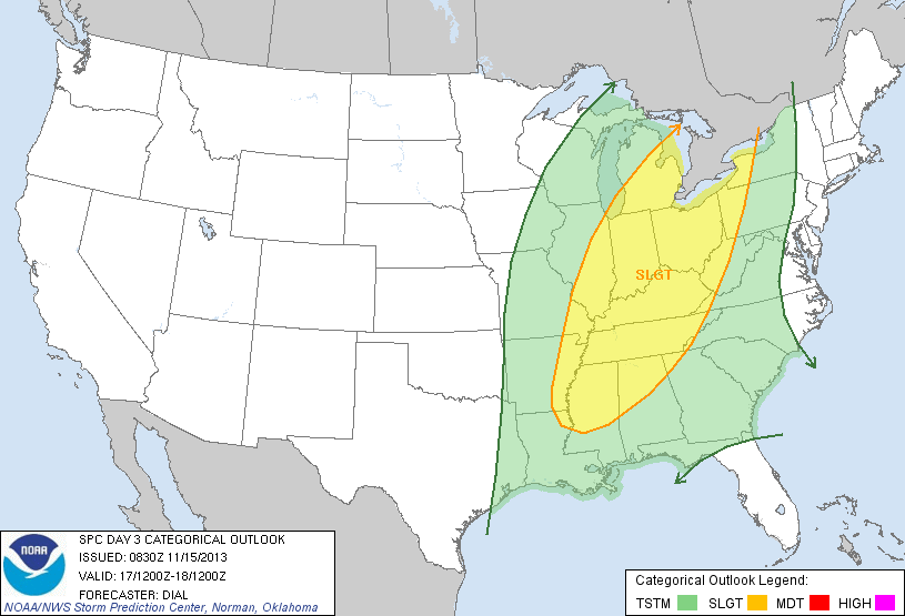
Clearly the highest risk of severe weather will be north of Alabama, where there is better dynamic support and stronger wind fields. I think strong straight line winds are likely Sunday evening over parts of Tennessee, Kentucky, Ohio and Michigan.
Down our way, I am still less than impressed with the severe weather risk. Instability values are very marginal Sunday night (surface based CAPE values under 500 j/kg), which will be the big limiting factor. A few strong storms are possible ahead of the front Sunday evening as they move into Northwest Alabama, but they should weaken with time as they move deeper into the state. Storms could produce gusty winds and some thunder, but again for now I don’t expect any big severe weather problems around here.
But remember, when it comes to thunderstorms, expected the unexpected, so we will watch trends over the weekend.
While showers are certainly possible during the day, the main window for the storms ahead of the cold front will come from about 6:00 p.m. until 12:00 midnight. Rain amounts of 1/2 to 1 inch can be expected.
Take a few minutes to watch the Weather Xtreme video for a detailed briefing with the maps and graphics.
FOOTBALL WEATHER: Mostly cloudy conditions for the high school football playoff games tonight… it looks like the rain will be over in time for kickoff at most stadiums; just a slim risk of a stray shower during the first quarter of the games. Temperatures will fall from near 57 degrees at kickoff to near 54 degrees by the final whistle.
Tomorrow, Auburn hosts Georgia at Jordan-Hare Stadium (2:30p CT kickoff)… the sky will be partly sunny with just a very small risk of a shower. The kickoff temperature will be near 67 degrees, falling into the low 60s by the fourth quarter. Alabama travels to Starkville to take on the Mississippi State Bulldogs (6:45p CT kickoff); the sky will be mostly cloudy with only a small risk of a shower. Temperatures will hold steady in the mid 60s during the game.
UAB is on the road; they play East Carolina in Greenville, NC tomorrow (1:00p CT kickoff). The sky will be mostly cloudy with a small chance of a shower. About 66 degrees at kickoff; temperatures will hold in the mid 60s through the game.
NEXT WEEK: The rain should end before sunrise Monday, and the sky will be generally sunny Monday with a high in the 60s. Then, cool and dry weather is the story for mid-week; the coldest morning should come early Wednesday with a low in the mid 30s.
THE LAND OF VOODOO: The 06Z GFS is showing a fairly wet weekend for November 23-24, followed by dry weather for Thanksgiving week across Alabama. See the Weather Xtreme video for the details.
WEATHER BRAINS: Don’t forget you can listen to our weekly 90 minute netcast anytime on the web, or on iTunes. This is the show all about weather featuring many familiar voices, including our meteorologists here at ABC 33/40.
CONNECT: You can find me on all of the major social networks…
Facebook
Twitter
Google Plus
Instagram
I will be doing a weather program this morning at Salter Elementary in Talledega; look for the next Weather Xtreme video here by 4:00 this afternoon. Enjoy the day…
Category: Alabama's Weather
About the Author (Author Profile)
James Spann is one of the most recognized and trusted television meteorologists in the industry. He holds the AMS CCM designation and television seals from the AMS and NWA. He is a past winner of the Broadcast Meteorologist of the Year from both professional organizations.Subscribe
If you enjoyed this article, subscribe to receive more just like it.


