Here Comes The Cold Air
An all new edition of the ABC 33/40 Weather Xtreme video is available in the player on the right sidebar of the blog. You can subscribe to the Weather Xtreme video on iTunes by clicking here.
HUGE CONTRAST: As promised, we have a big time thermal gradient across Alabama at daybreak, with 30s over the northwest counties, and 70s over some eastern counties…
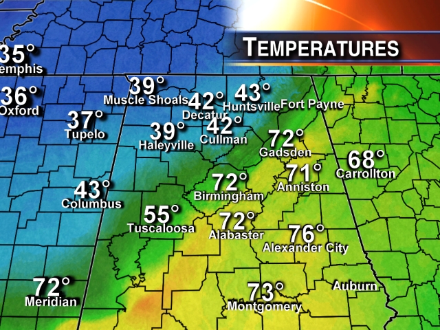
At 5:00 a.m., we had a 30 degree swing across the Birmingham metro as the front was right over the city. The western suburbs were in the 40s, eastern suburbs were in the 70s.
THE DAY AHEAD: The cold air wins the battle, and where it is warm now, temperatures will fall into the 40s. Periods of rain are likely through tonight, and a few thunderstorms are possible south of the Arctic boundary, but there is no formal severe weather risk as the parameters remain marginal.
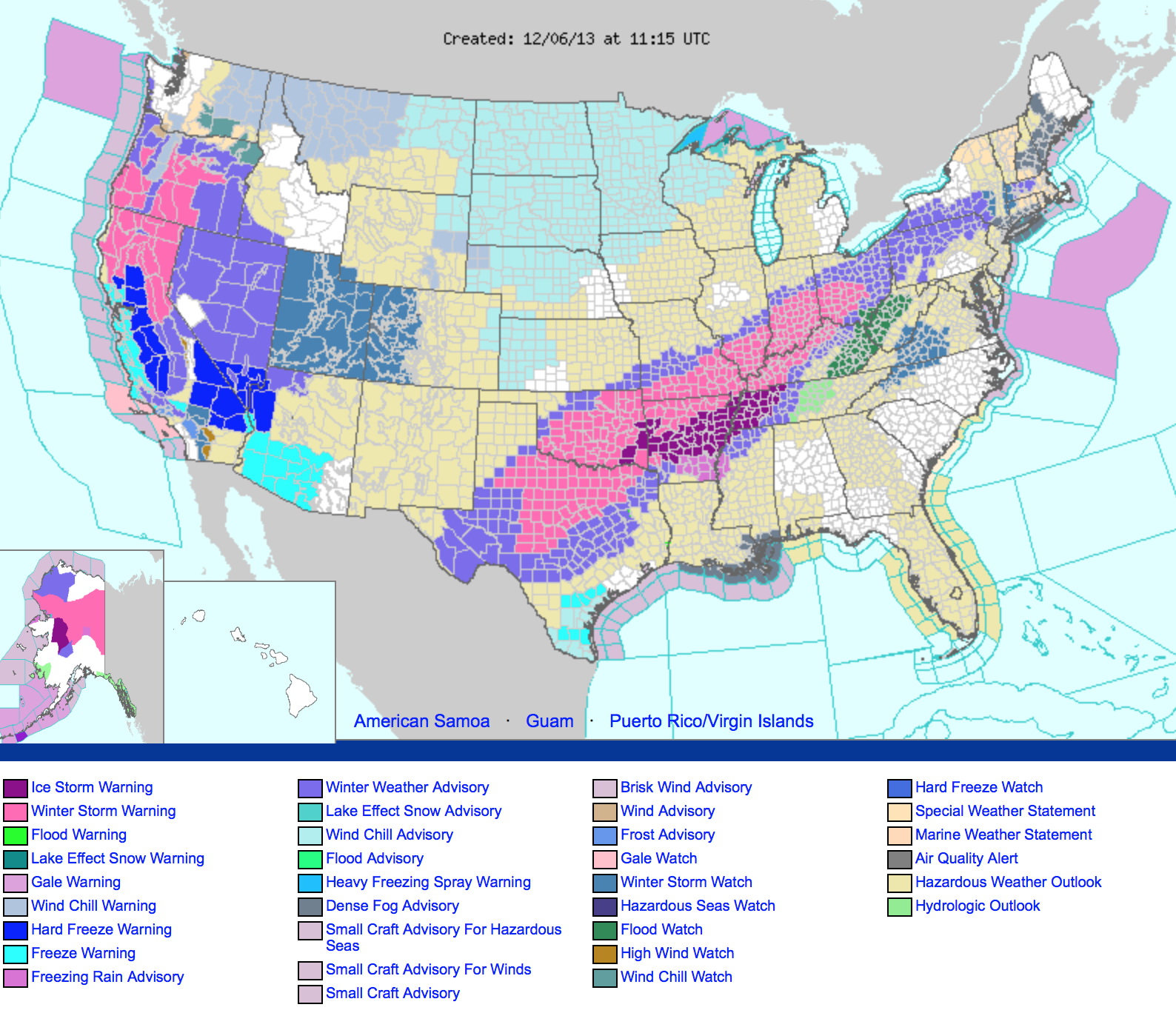
TO THE WEST: Ice storm warnings remain in effect for parts of Arkansas and West Tennessee, including Memphis and Little Rock. Winter storm warnings are up all the way from Texas to Ohio; if you are traveling to these areas, be ready for big headaches. Travel in some places will be difficult, if not impossible. Power outages are reported in parts of Texas, Oklahoma, and Arkansas due to ice accumulation.
TONIGHT: Thankfully it looks like most of the rain will end before temperatures get below freezing over the northwest corner of the state, but there still could be a touch of freezing drizzle with temperatures in the 28-32 degree range up that way. Don’t think there will be too many problems, but I still can’t rule out a touch of bridge icing.
COLD SATURDAY: Tomorrow will be cloudy and cold with a high in the 40s. There could be a little light rain or drizzle at times, but a decent part of the day will be rain-free despite the cloud cover as we will be in between waves.
MORE RAIN SUNDAY/MONDAY: A soaking rain is likely on these two days, and the rain might even be heavy at times as a warm front tries to push northward. I think most North Alabama communities hold in the 40s during the day Sunday, but a nose of warmer air will push in here late in the day and Sunday night. We could very well have rising temperatures Sunday evening; the ECMWF suggests Birmingham might touch 60 degrees Sunday night. But, often it is very hard to dislodge cold air, and that warm-up might be a little too aggressive.
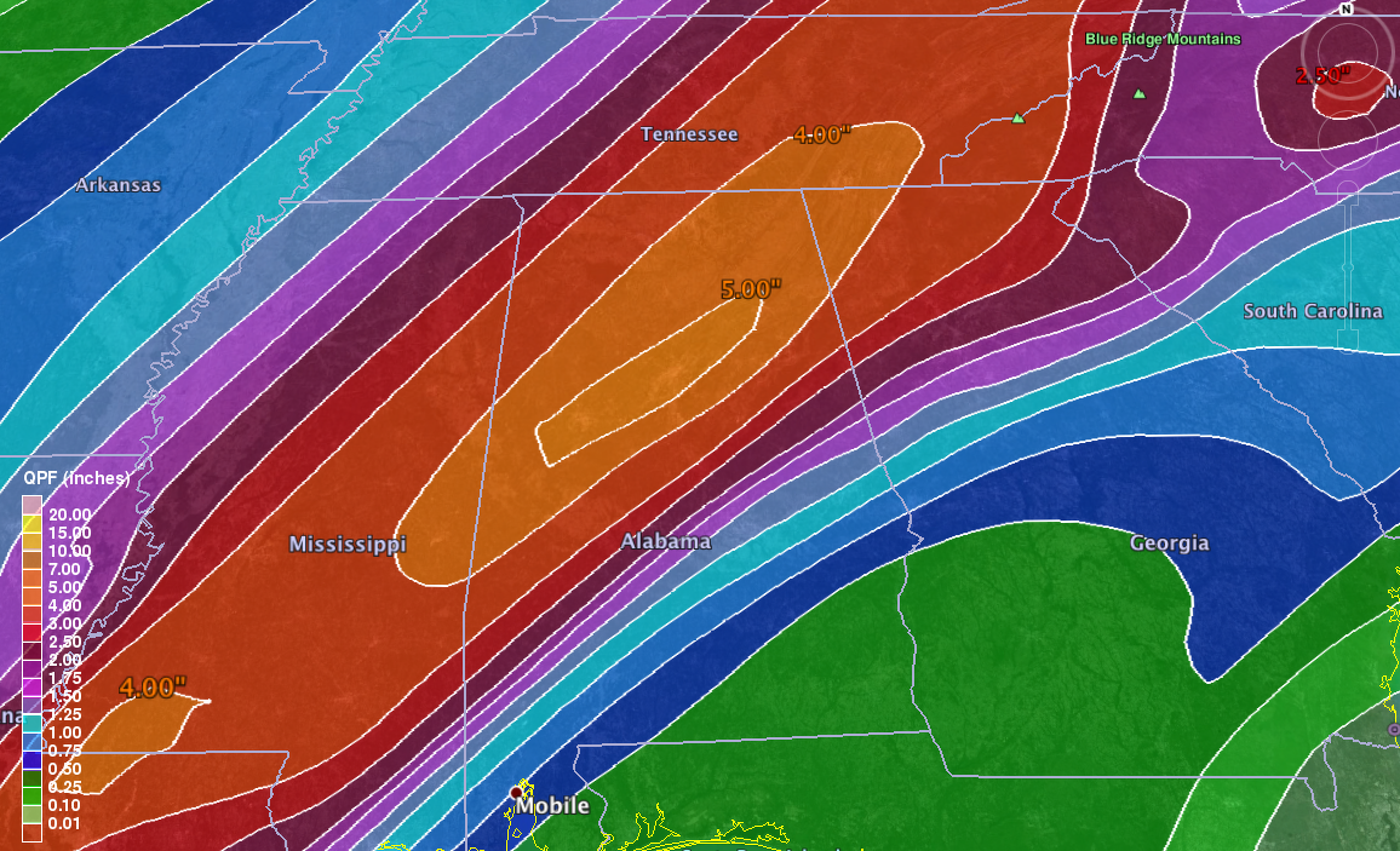
The rain continues Monday with temperatures generally in the 50s. We might have some flooding issues before it all ends Monday night; the QPF guidance suggests five inches of rain right along the I-59 corridor over the next five days…
MUCH COLDER TUESDAY: Cold air drops into the state Tuesday with a brisk north wind; communities north of Birmingham might have a hard time getting out of the 30s; the high will be in the 40s elsewhere. Might see a few light snow flurries Tuesday morning with the arrival of the cold air, but they should not amount to much. The sky will clear Tuesday afternoon.
REST OF NEXT WEEK: Wednesday morning will be cold with a low well down in the 20s; colder pockets could visit the upper teens. But, at least the sun will be out in full force Wednesday, and we should see a high near 60. We stay dry Thursday and Friday.
The GFS hints at a soaking rain event around the weekend of December 14-15… see the Weather Xtreme video for more details, and all the maps and graphics.
SUPER SIX FOOTBALL: Rain is likely in Tuscaloosa this afternoon and tonight, and temperatures will fall into the 40s by afternoon, with upper 30s likely soon after sundown. It will be a cold and wet day for football.
SEC CHAMPIONSHIP: Of course, tomorrow’s title game in Atlanta which features Auburn vs Missouri will be played in the dome, but for fans headed over that way the day will be wet with light rain at times and a high around 50 degrees.
WEATHER BRAINS: Don’t forget you can listen to our weekly 90 minute netcast anytime on the web, or on iTunes. This is the show all about weather featuring many familiar voices, including our meteorologists here at ABC 33/40.
CONNECT: You can find me on all of the major social networks…
Facebook
Twitter
Google Plus
Instagram
I will be doing a weather program today at Glencoe Middle School in Etowah County… be looking for the next Weather Xtreme video here by 4:00 this afternoon. Enjoy the day!
Category: Alabama's Weather
About the Author (Author Profile)
James Spann is one of the most recognized and trusted television meteorologists in the industry. He holds the AMS CCM designation and television seals from the AMS and NWA. He is a past winner of the Broadcast Meteorologist of the Year from both professional organizations.Subscribe
If you enjoyed this article, subscribe to receive more just like it.


Comments (28)
Trackback URL | Comments RSS Feed
Sites That Link to this Post