National Notes
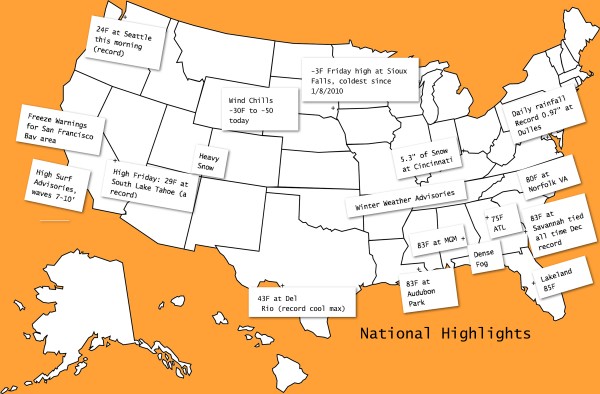
The graphic is a nod to my hero, Weather Historian David Ludlum, who founded and edited Weatherwise Magazine for years. His simple monthly weather and annual weather highlights with historical events typed on slips and pasted on the maps are classic fare.
A few entries from the Weather Notebook about the remarkable weather pattern over the United States right now. The big trough and arctic airmass brought along a slew of records with it on Friday.
Some of the notable record highs ahead of the trough included:
85F at Lakeland FL
83F at Montgomery and Jacksonville FL
82F at Augusta GA and New Bern NC
80F at Pensacola FL, Norfolk VA and Fayetteville NC
The 78F at Anniston tied the record for the date.
The 85F at Savannah tied the all time December record there.
The 43F at Del Rio TX and the 29F at South Lake Tahoe CA were record cold maximum highs.
In the cold air, some record lows included:
-27F at Laramie, WY
-25F at Alliance NE
-23F at Chadron NE
-24F at Grand Forks ND
It was 18F at the North Rim of the Grand Canyon.
In the battle zone between the opposing air masses, there were snowfall and rainfall records, including:
3.5” of snow at Louisville
5.1” at Columbus OH
5.3” at Cincinnati
Dallas picked up .4 inches, a new record for the date to put on the mantle with the 0.1” record they posted on Thursday.
Dulles Airport in Washington picked up 0.97” of rain on Friday, a record for the date.
Fog was a problem across South Georgia and the Florida Big Bend area. Visibilities were less than a quarter of a mile at Tallahassee this morning.
Winter advisories cover about 30% of the U.S. this morning, some for today, some for tomorrow and Monday. Heavy snow is expected across the Intermountain Region of the West today and tonight in places like Cedar City UT. 8-14 inches of snow is expected in the San Juan Mountains of southwestern Colorado. Wind chill advisories and warnings are in effect for a large area from eastern Washington and Oregon across the northern Plains to Minnesota. Wind chill values across parts of the Dakotas are expected to be -35F to -50F this afternoon.
Winter weather advisories are posted from eastern Arkansas into northwestern Mississippi and western and Middle Tennessee for a wintry mix that is expected to develop tonight through Sunday in those areas. As this system builds eastward, winter storm watches and warnings are in effect for North Carolina, Virginia, West Virginia and D.C. Snowfall amounts are only expected to be 1 to 2 inches, but there is a threat of freezing rain right behind it that could be much more serious.
SURF’S UP
High surf advisories are in effect along the beaches of Southern California where 7-10 foot waves are expected today. Rip currents will be a big problem.
Category: Headlines


