Socked In…Still
Alabama has been socked in with a thick deck of gray, stratus clouds on this mid-December Sunday, but take heart, that bright yellow orb will be returning to a sky near you soon.
WHO DO WE THANK? Being facetious of course, but we can thank leftover low-level moisture and a bit of a temperature inversion at about 5,000 feet for today’s clouds. Throw in the arrival of cold air from in the lower levels of the atmosphere keeping the relative humidity high and helping the clouds hang touch.
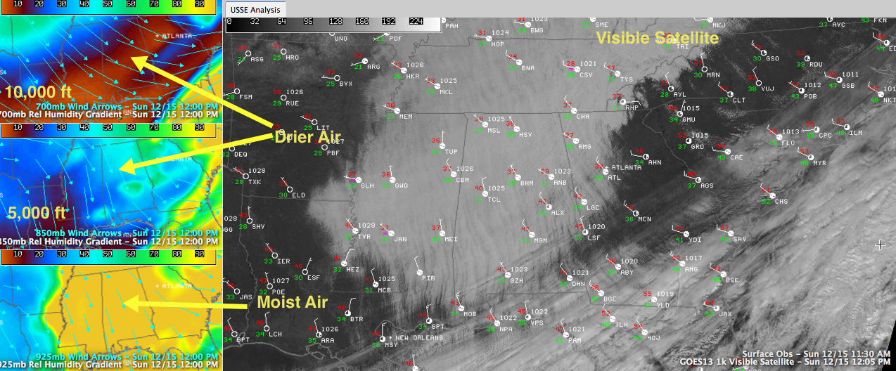
RECIPE FOR SUNSHINE: Drier air has been moving in aloft all morning. You can see that on the top two smaller panels of the graphic. (Click the graphic to enlarge it.) The drier air will help. And gradually the inversion will be wiped out, allowing for some mixing of the lower layers of the atmosphere. You will see some breaks in the clouds start to appear, and that will allow for a modest amount of surface heating, enough to increase the mixing, helping the process along. It will take until after sunset for the clouds to be gone, and the overnight hours should be clear.
COULD THERE BE FOG? With clear skies, we start thinking about good radiational cooling. There will be a little mist in the air late tonight and early tomorrow morning, but it will not restrict visibility enough to qualify as fog. The threshold for it to be defined as fog is when visibilities less than one kilometer.
BUT IT WILL BE CHILLY: With the clear skies overnight, the mercury will retreat quickly and will be in the upper 20s to lower 30s by morning.
THAT YELLOW ORB: Oh, a quick question. I mentioned a yellow orb earlier, namely the sun. When you were drawing as a kid, did you color your suns orange, or yellow? Did you ever stop to think what color the sun really is? It actually is white, since I is throwing out light in lots of wavelengths. Our atmosphere does a good job of absorbing the shorter wavelengths though, filtering out the blues and greens and delivering the sun to us in hues of yellow, orange or red. Next topic: why is the sky blue. Hahahaha!
SUNSHINE AHEAD: No matter what color you picture the sun as, you will see lots of it Monday and Tuesday. That, combined with our winds shifting around to the southwest in response to a surface ridge that will begin building over us, will allow the mercury to moderate a bit. We will be in the 50s Monday and 50s pushing 60F on Tuesday. 60s should be common by Wednesday. Lows Monday, Tuesday and Wednesday will be in the middle 30s.
MIDWEEK AND BEYOND: BY Thursday, our upper level winds will become southwesterly as well, and that will accelerate the warm up and the return of moisture. Clouds will start increasing on Thursday and showers could appear as early as Thursday night. There is not good consistency in the data for the weekend. The European and GFS had been in good agreement that there would be an extended periods of rain and storms starting Friday and peaking on Saturday, departing during the day on Sunday. Early looks at this morning’s European seem to confirm that while the GFS has gone a totally different direction. For now, we will stick with the idea that the weekend will be wet.
Category: Alabama's Weather
About the Author (Author Profile)
Bill Murray is the President of The Weather Factory. He is the site's official weather historian and a weekend forecaster. He also anchors the site's severe weather coverage. Bill Murray is the proud holder of National Weather Association Digital Seal #0001 @wxhistorianSubscribe
If you enjoyed this article, subscribe to receive more just like it.


