

Into The 70s By Saturday
An all new edition of the ABC 33/40 Weather Xtreme video is available in the player on the right sidebar of the blog. You can subscribe to the Weather Xtreme video on iTunes by clicking here.
FINE DECEMBER DAY: With a mostly sunny sky, temperatures are in the 60s over most of Alabama this afternoon. Not hearing too many complaints about this weather.
The warm-up continues tomorrow as we rise into the upper 60s. The sky will be mostly cloudy tomorrow as low level moisture levels rise, and a few widely scattered showers could break out by afternoon, but most of the day should be dry.
RECORD WARMTH POSSIBLE SATURDAY: The 12Z GFS is printing a high of 74 degrees for Birmingham Saturday, and if that verifies it will be a new record, beating the 73 degree high recorded on December 21, 1923. The day will be warm and breezy, and while a few passing showers are certainly possible, a decent part of the day should be rain-free. Maybe even a peek or two of sun.
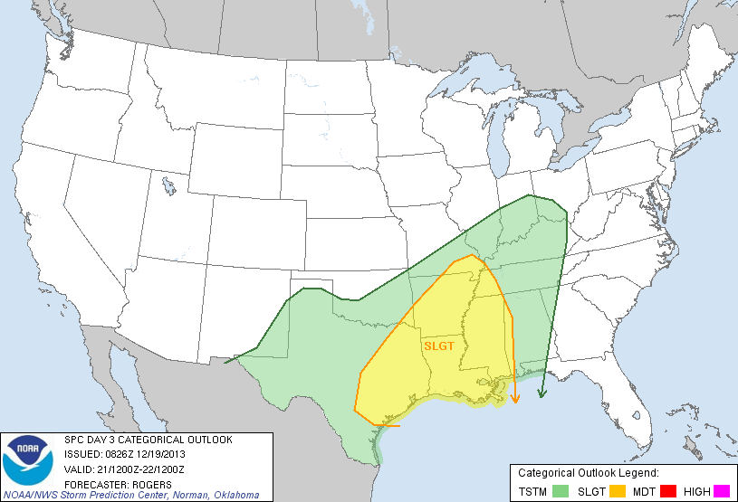
TO THE WEST: SPC maintains the standard “slight risk” of severe weather for areas to the west of Alabama Saturday and Saturday night; this includes all of Louisiana and Mississippi along with some of the adjacent states.
Also, for travelers, winter storm warnings are up from Kansas to the Great Lakes due to snow and ice potential in the cold sector of the storm.
STORMS ARRIVE LATE SATURDAY NIGHT: Finally getting some decent model agreement on the timing of the weekend thunderstorm event….
TIMING: While storms could enter far West Alabama around 10:00 p.m. Saturday, looks like the main window for organized thunderstorms will come from about midnight Saturday night until 9:00 a.m. Sunday. For many of you across North-Central Alabama, the storms will blow through during the pre-dawn hours while most are sleeping.
MAGNITUDE OF THE THREAT: I agree what what the NWS Huntsville said in their afternoon briefing… “Not expecting a widespread severe/flash flood threat with this event”. Understand there is no doubt some severe weather is possible, but I agree this is not a really major event. In fact, SPC does not any formal severe weather risk defined in their “Day Four” outlook for Sunday. I do expect them to put up the standard “slight risk” for parts of Northwest Alabama eventually.
MODES OF SEVERE WEATHER: Clearly the most impressive feature with the incoming storm system is the low level jet (around 5,000 feet off the ground). Wind speeds in excess of 50-60 knots are showing up in model output, and it won’t take much to bring that down to the surface with heavier thunderstorms. So, it looks like the main issue will be strong winds along the squall line as it advances through the state early Sunday morning.
Straight line winds could be enough to knock down trees and power lines in scattered spots.
There is a decent amount of shear within the lower 3,000 feet of the atmosphere, so an isolated tornado is not out of the question if there are breaks or kinks in the line, but any tornadoes, most likely, will be short lived.
RAIN: Rain amounts of around one inch are likely, and we don’t expect any flooding issues on a widespread basis.
I expect a number of severe thunderstorm warnings to be issued late Saturday night and early Sunday, and maybe even a tornado warning or two. Be sure your NOAA Weather Radio is working properly so you can get the warnings since they will come in the “middle of the night”.
CHRISTMAS WEEK: Monday will be breezy and colder with a clearing sky; we might have a hard time getting out of the 40s with a chilly north wind. Tuesday and Christmas Day will be sunny with cold mornings; early morning lows will be in the mid to upper 20s, with the afternoon high around 50 degrees. No snow for Christmas this year.
Be sure and see the Weather Xtreme video for the maps, graphics, and more details.
WEATHER BRAINS: Don’t forget you can listen to our weekly 90 minute netcast anytime on the web, or on iTunes. This is the show all about weather featuring many familiar voices, including our meteorologists here at ABC 33/40.
CONNECT: You can find me on all of the major social networks…
Facebook
Twitter
Google Plus
Instagram
I had a great time today visiting with the third graders at Cherokee Bend Elementary School in Mountain Brook… be looking for them on the Pepsi KIDCAM today at 5:00 on ABC 33/40 News! The next Weather Xtreme video will be posted here by 7:00 a.m. tomorrow…
Category: Alabama's Weather
About the Author (Author Profile)
James Spann is one of the most recognized and trusted television meteorologists in the industry. He holds the AMS CCM designation and television seals from the AMS and NWA. He is a past winner of the Broadcast Meteorologist of the Year from both professional organizations.Subscribe
If you enjoyed this article, subscribe to receive more just like it.


