

Strong Storms This Weekend
An all new edition of the ABC 33/40 Weather Xtreme video is available in the player on the right sidebar of the blog. You can subscribe to the Weather Xtreme video on iTunes by clicking here.
WARMING TREND AHEAD: Another cold morning across Alabama, with some places reaching the 20s at daybreak, but we warm up nicely today with a strong December sun; most communities will see a high in the low 60s this afternoon.
MOISTURE RETURNS TOMORROW: The sky will become mostly cloudy tomorrow, but I don’t expect anything beyond widely scattered afternoon showers. The high will be in the upper 60s, about ten degrees above average levels for late December in Alabama.
UNSETTLED WEEKEND WEATHER: A strong upper low will lift out of the Southwest U.S. over the weekend, bringing the threat of severe weather to areas west of Alabama Saturday afternoon and Saturday night. SPC has the standard “slight risk” of severe weather up for much of East Texas, Louisiana, Arkansas, Mississippi, and West Tennessee.
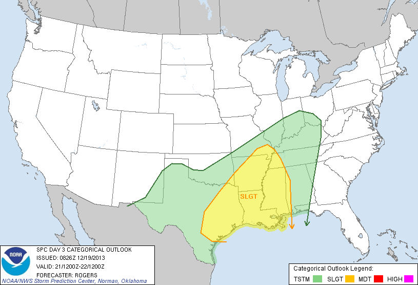
The higher probabilities for severe weather are centered around Shreveport and the Ark-La-Tex region.
Here in Alabama, Saturday will be warm and breezy with a high up in the mid 70s. A pretty decent we establish a new record high… the current record for December 21 is 73 set in 1923. A few showers are certainly possible, but a decent part of the day will be dry. Maybe even a peek of sun occasionally.
THE ALABAMA THUNDERSTORM SITUATION: We still have some big model differences this morning. The GFS model is the fast one, bringing the band of storms through here late Saturday night into early Sunday morning; the NAM is an outlier on the slow side, and holds off the storms until Sunday afternoon. There is actually a little credibility with the NAM idea with a very strong ridge just east of Alabama, which just might shunt the main dynamics west and north of here.
But, here is our thinking for now.
TIMING: The main window for strong/severe storms will come from around midnight Saturday night through 12:00 noon Sunday.
THREAT LEVEL: I would not consider this a “major” severe weather threat, and for now the Storm Prediction Center does not have any formal risk up for day four (Sunday) due to the uncertainty involved. But, if one tree is blown down, and it happens to be blown into your home, then it becomes “major” to you, so we all have to pay attention to the weather this weekend. I do expect SPC at some point to issue their standard “slight risk” for a part of Alabama for Sunday morning.
PLACEMENT: The higher risk of severe weather in Alabama will be generally west of I-65 early Sunday, where there will be better dynamic support.
MODES OF SEVERE WEATHER: I believe this will be a mostly linear event, meaning one long squall line (or QLCS… quasi-linear convective system) will pass through, with the main threat coming from strong straight line winds. The GFS continues to show level jet (5,000 feet off the ground) speeds of 50 knots or higher, and some of that could be transported down to the surface. Perhaps enough wind in spots to knock down trees and power lines.
The bulk shear values in the lower levels have come down, but still there is enough for some isolated tornado threat if there are kinks or breaks in the line.
RAIN AMOUNTS: The rain totals around here should be around one inch over the weekend, not enough for any flooding issues despite very high precipitable water values.
I expect a number of severe thunderstorm warnings to be issued Sunday morning, be sure your church has a good way of getting severe weather information since many will be attending services on this pre-Christmas weekend.
FOR TRAVELERS: Be aware that snow and ice is possible up in the cold air sector of the storm from parts of the Southern Plains up to the Great Lakes.
See the Weather Xtreme video for all the maps, graphics, and more details on this developing storm system.
CHRISTMAS WEEK: The sky becomes sunny on Monday, but the day will be breezy and cool with a high near or just over 50 degrees. The weather stays cool and dry Tuesday and Christmas Day with highs in the low to mid 50s, right at seasonal averages for late December. Sunny days, clear nights, no snow.
LONFG RANGE: The GFS continues the idea of a pretty decent wet down here just before New Year’s Day… check the video for the details.
WEATHER BRAINS: Don’t forget you can listen to our weekly 90 minute netcast anytime on the web, or on iTunes. This is the show all about weather featuring many familiar voices, including our meteorologists here at ABC 33/40.
CONNECT: You can find me on all of the major social networks…
Facebook
Twitter
Google Plus
Instagram
I will be doing my last school weather program of 2013 today at Cherokee Bend Elementary in Mountain Brook… look for the next Weather Xtreme video here by 4:00 or so this afternoon. Enjoy the day!
Category: Alabama's Weather
About the Author (Author Profile)
James Spann is one of the most recognized and trusted television meteorologists in the industry. He holds the AMS CCM designation and television seals from the AMS and NWA. He is a past winner of the Broadcast Meteorologist of the Year from both professional organizations.Subscribe
If you enjoyed this article, subscribe to receive more just like it.


