

One More Dry Day
An all new edition of the ABC 33/40 Weather Xtreme video is available in the player on the right sidebar of the blog. You can subscribe to the Weather Xtreme video on iTunes by clicking here.
SEVERE CLEAR: Nothing but sunshine across Alabama this afternoon. As expected, temperatures are cooler; most communities are in the mid 50s as I write this. Tonight will be clear and cold with a low around the freezing mark by early tomorrow morning.
Tomorrow will be another sunny day with a high in the low to mid 60s.
FRIDAY: The sky becomes mostly cloudy Friday as moisture returns, and a few showers could develop Friday afternoon. But, with little dynamic support the showers Friday should be widely spaced, and a pretty decent part of the day will be dry with a high in the mid 60s.
SATURDAY: We start the weekend with a warm, breezy day. The sky will be mostly cloudy, and a few showers are certainly possible, but the big rain/storm event will be west of Alabama, so much of the day will be dry with just a few passing showers. The latest run of the GFS model is printing a high of 71 degrees for Birmingham on Saturday, just shy of the record high for December 21, 73 set in 1923.
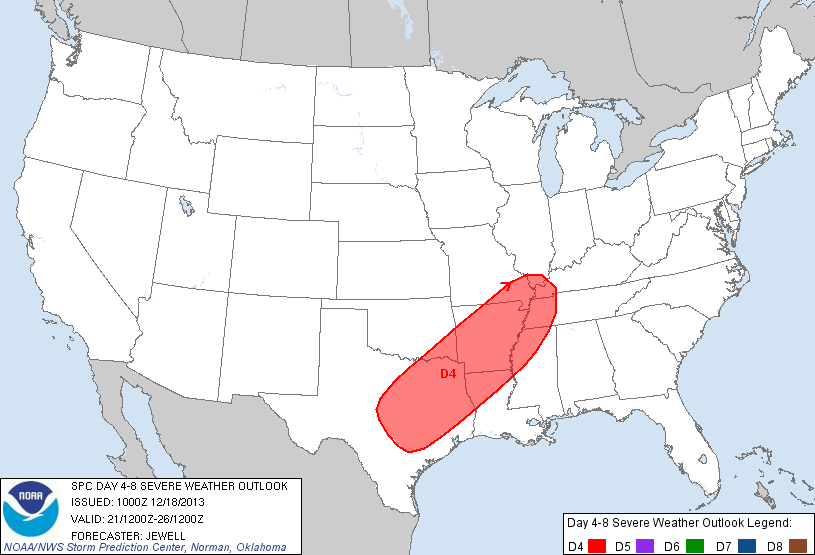
TO THE WEST: SPC has the area from East Texas to West Tennessee and Kentucky under a risk of severe weather Saturday; be aware of this if you are traveling that way.
STORMY SUNDAY: Finally getting better model agreement on the event late this weekend as the GFS model is now slower, and closer to the ECMWF. The main twelve hour window for strong storms will come from about 3:00 a.m. until 3:00 p.m. Sunday, although storms could be near the northwest corner of Alabama by midnight Saturday night.
The primary surface low will move from near Little Rock to Detroit Sunday, with a trailing cold front moving into the state. Strong wind fields at 5,000 feet (the low level jet) near 50-60 knots suggest that the squall line ahead of the front could bring strong straight line winds, perhaps enough to knock down some trees and power lines. There will be sufficient shear for an isolated tornado or two, but it looks like the storms will linear in nature with the main threat coming from straight line winds.
There is no formal risk of severe weather defined now for Alabama Sunday from SPC, but I figure at some point they will issue the standard “slight risk” for at least the northern half of the state. Not sure I would call this a “major” severe weather threat, but we have to watch any dynamic system during December… this is the core of the fall tornado season in Alabama.
CHRISTMAS WEEK: Monday will be breezy and colder as the sky becomes mostly sunny. The high will be around 50 degrees with a cool north wind of 10-20 mph.
Tuesday, and Christmas Day Wednesday will be cool and dry with temperatures right at seasonal averages; highs in the 50s. The low early Tuesday will be in the 20s, and we expect a low in the lower 30s at daybreak Wednesday. Lots of sunshine both days, no snow around here. In fact, a large percentage of the U.S. looks dry on Christmas Day.
LONG RANGE/VOODOO LAND: The GFS continues to hint at a wet weather system impacting Alabama just before New Year’s Day; see the Weather Xtreme video for the maps, graphics, and details.
TOYS FOR TOTS: We wrap up our 26 hour Toys for Tots drive this evening; I will be live at Southern Legacy BBQ on Highway 150 in Hoover at 4, 5, and 6:00. Come by and bring a new, unwrapped toy!
WEATHER BRAINS: Don’t forget you can listen to our weekly 90 minute netcast anytime on the web, or on iTunes. This is the show all about weather featuring many familiar voices, including our meteorologists here at ABC 33/40.
CONNECT: You can find me on all of the major social networks…
Facebook
Twitter
Google Plus
Instagram
Look for the next Weather Xtreme video here by 7:00 a.m. tomorrow…
Category: Alabama's Weather
About the Author (Author Profile)
James Spann is one of the most recognized and trusted television meteorologists in the industry. He holds the AMS CCM designation and television seals from the AMS and NWA. He is a past winner of the Broadcast Meteorologist of the Year from both professional organizations.Subscribe
If you enjoyed this article, subscribe to receive more just like it.


