

Snow/Cold Notes…
Not much change in our overall thinking on how things unfold in coming days. Here is a Saturday morning update.
SUNDAY NIGHT SNOW: We expect a dusting to 1/2 inch for much of North/Central Alabama tomorrow night.
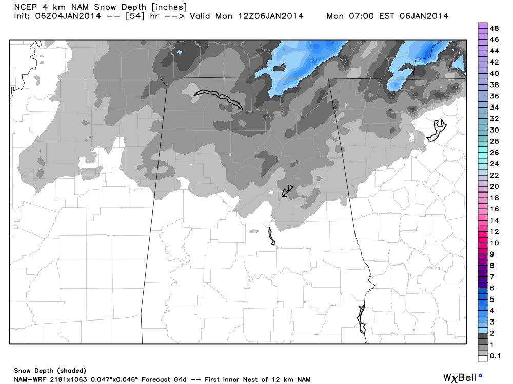
The high resolution NAM model confirms this idea; the best chance of more than 1/2 inch will come across high terrain of Northeast Alabama, where a few spots might see over one inch. The main window for snow will come from 6 p.m. Sunday through 3 a.m. Monday.
A few points about the snow event…
*Sunday afternoon will be relatively “warm” with a high in the mid 50s, and it will rain ahead of the Arctic front.
*Temperatures will drop dramatically once the front passes, creating a “flash freeze” effect, and any liquid on roads and bridges will freeze very quickly, creating the problem of icy travel. We will go from the 50s to the 20s in 30 minutes in some cases.
*The snow won’t last long, and in the overall scheme of things it is not a “big deal”. Some places will see only a few flakes and no accumulation, but some could see up to 1/2 inch around here. The cold air is clearly the “big deal”. But, slick spots on roads are a very real possibility Sunday night into Monday morning due to the flash freeze situation and potential for black ice, even if there is no snow at all.
*It doesn’t make sense to ask about certain counties or towns when it comes to snow accumulation. We are broad brushing the forecast with a “dusting to 1/2 inch” for all of North-Cental Alabama,
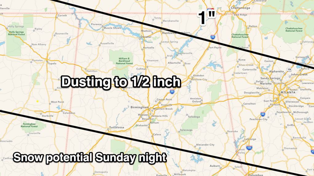
Best chance of seeing snow flakes will be north of a line from Tuscaloosa to Jemison to Opelika, but some snow is possible south of that line, where no accumulation is expected.
BRUTAL COLD NEXT WEEK: We expect to be below freezing around here (Birmingham, Tuscaloosa, Anniston, Gadsden) for about 62 to 65 consecutive hours from Sunday night through midday Wednesday.
Let’s break it down by day…
MONDAY: The latest GFS is projecting a low of 14 for Birmingham Monday morning. Some runs have been as low as 10, but the biggest issue is the wind, which will be out of the north at 15 to 30 mph. This will create wind chill index values as low as 15 degrees BELOW ZERO.
We won’t get past the low 20s Monday, and the wind chill index will remain below zero basically all day. The last time we had a high below 25 degrees was on February 4, 1996.
TUESDAY: The GFS is now printing a low of 5 degrees for Birmingham early Tuesday. The last time we saw a low below 7 degrees was February 5, 1996 when our low was 6 degrees. The high Tuesday will be in the upper 20s, but thankfully the wind will be much lighter than Monday.
WEDNESDAY: Wednesday morning will feature a low between 11 and 16, and finally we rise above the freezing mark by late morning.
Bottom line is that this now looks like the coldest air we have experienced in about 18 years. Be sure your exposed pipes are protected, check on elderly people that might not have adequate heat, and bring in your pets next week. More updates later…
Category: Alabama's Weather
About the Author (Author Profile)
James Spann is one of the most recognized and trusted television meteorologists in the industry. He holds the AMS CCM designation and television seals from the AMS and NWA. He is a past winner of the Broadcast Meteorologist of the Year from both professional organizations.Subscribe
If you enjoyed this article, subscribe to receive more just like it.


