Afternoon Update/Winter Storm Watch Issued For Tuesday
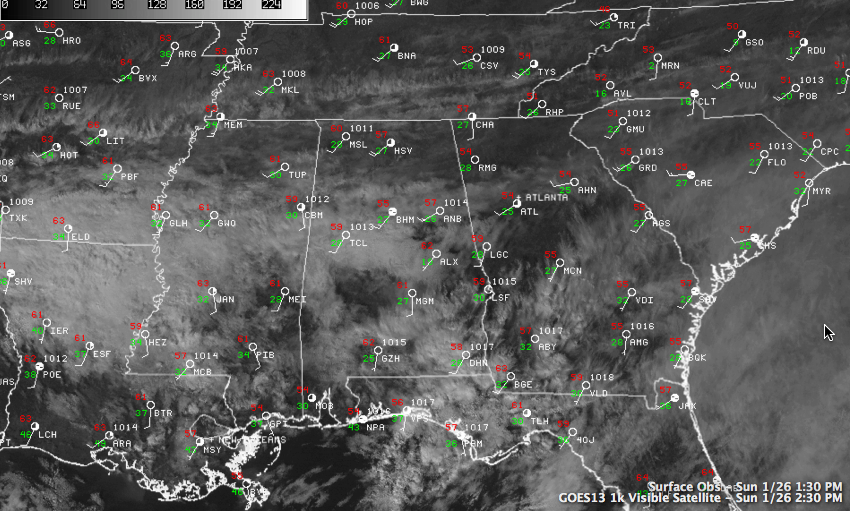
A very nice January day is in progress across Central Alabama. Temperatures in the 50s feel like an absolute heat wave. At 1 p.m., it was 56F in Birmingham, 59F at Tuscaloosa and 57F at Aniston. In Muscle Shoals, it was 60F, and it was as well at Calera. Skies were variably cloudy, with a heavier band of clouds across North Central Alabama and another one down the western wide of the state. Low pressure near Wichita Falls, Texas was slowly getting its act together, trying to pull a warm front over the northern Gulf back ashore. A few light showers were showing up on regional radars from Louisiana and Arkansas across southern Mississippi and southern Alabama. But the air in those areas is still very dry and that precipitation is having a hard time reaching the surface. I couldn’t find any surface reports of precipitation at 1 p.m. A cold front now over the northern Plains will race southeastward overnight, covering about 800 miles in 21 hours to reach the I-59 corridor around 8-9 a.m.
WINTER STORM WATCH ISSUED
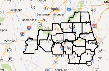
The NWS in Birmingham has issued a Winter Storm Watch for some of its counties in Central Alabama starting Tuesday morning at 9 a.m. Counties in the watch are: Autauga, Barbour, Bullock, Chambers, Chilton, Clay, Coosa, Dallas, Elmore, Lee, Lowndes, Macon, Marengo, Montgomery, Perry, Pike, Randolph, Russell and Tallapoosa Counties. It goes until Wednesday morning.
This is in addition to the Winter Storm Watch that has been issued by the NWS Tallahassee for Southeast Alabama. The NWS Mobile says they will issue their product around 4 p.m.
MORE COLD AHEAD
The big story is more cold as another front arrives early Monday. Ahead of the front, temperatures will hold steady in the lower 40s Monday morning, but within a couple of hours of frontal passage, temperatures will fall back into the lower and middle 30s.. Skies will be cloudy to start the day, but expect increasing sunshine as you head through the day, but the temperatures won’t be helped very much. Temperatures should reach the freezing mark by dark, and there they may stay for quite some time. It will become windy during the day as well, making it feel even colder. After dark, wind chills will be in the teens and sometimes in the single digits. By Tuesday morning, temperatures will range from 16-21F in the I-5 corridor, with colder readings to the northwest and lower 20s to the southeast.
Skies should become cloudy again Monday night as moisture spreads back northward. A wintry mix of snow and sleet is expected to develop across Central Alabama Tuesday. We could see a dusting as far north as I-20, with an inch of snow along and south of a line from Eutaw to Calera to Lineville. The best chance for snowfall accumulation will be south of a line from Chatom to Greenville to Phenix City. 2-3 inches of snow could fall in this area all the way to the Gulf Coast. Of course, if there is more sleet or freezing rain, this could reduce the snow accumulation, but would not reduce the potential for travel problems. Highs on Tuesday will range from 24F over the northwestern sections to 34F down around Phenix City. Expect upper 20s in the I-20 corridor.
TRAVEL PROBLEMS: We don’t expect any issues across Central Alabama, but in the areas south of US-80 and I-85, some issues could develop as we go through Tuesday afternoon and night into Wednesday morning. Folks traveling Tuesday into Wednesday anywhere from Houston to New Orleans along I-20 up into Central Louisiana, over the southern thirds of Alabama or Mississippi or across the Florida Panhandle need to pay attention to forecasts.
Category: Alabama's Weather, Winter Weather
About the Author (Author Profile)
Bill Murray is the President of The Weather Factory. He is the site's official weather historian and a weekend forecaster. He also anchors the site's severe weather coverage. Bill Murray is the proud holder of National Weather Association Digital Seal #0001 @wxhistorianSubscribe
If you enjoyed this article, subscribe to receive more just like it.


