

Late Night Forecast Update
I have just updated the Alagasco Seven Day Forecast and thought I would share the winter storm discussion portion with you.
ARCTIC AIR ARRIVES MONDAY: Even as the arctic airmass oozes in from the north on Monday behind a cold front, low pressure will be spinning up over the western Gulf of Mexico. This is generally the setup for winter storms in Alabama and the Deep South. Skies will remain mostly cloudy all day. In the I-20 corridor, temperatures will recover into the upper 40s by lunchtime, but will slowly recede during the afternoon. Further northwest, temperatures will drop to near freezing by 6 p.m. in the US-278 corridor and to I-20 by midnight. As the low-pressure system moves eastward, moisture will overspread the area resulting in precipitation. Rain will change to sleet and then to freezing rain as surface temps drop below 32F then to snow as the cold air layer deepens.
NORTHERN IMPACTS: There is still a lot of uncertainty about the evolution of the system and its accompanying impacts at this point. But there is increasing confidence that 2-4 inches of snow will fall in areas near and north of US-278 Monday night into early Tuesday. There could be a significant glaze of freezing precipitation first, which would provide a base for the snow that follows.
WINTER STORM WATCH: The NWS has already posted a winter storm watch for Monday night and Tuesday morning for Blount, Cherokee, Etowah, Fayette, Lamar, Marion, Walker and Winston Counties.
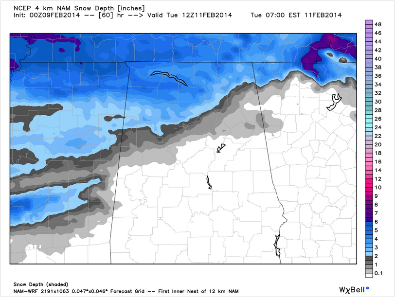
Here is the latest snow depth output from the NAM for early Tuesday morning:
SOUTHERN IMPACTS: A glaze will be followed by ½ to 2 inches of snow south of US-278 to around the I-20 corridor. There will be more snow to the north. Ice accumulations could total between 0.10 and 0.25 inches, perhaps as far as south as I-20. This could end up being a significant icing event that would cause significant impacts to travel late Monday night and early Tuesday. Hopefully, there won’t be enough ice accumulation to cause power outages, but that is not out of the question.
ADDITIONAL ADVISORIES? As confidence increases in the forecast, additional advisories or warnings may be issued later today for areas to the south of the current winter storm watch.
WHEN WILL CONDITIONS IMPROVE? Conditions will be slow to improve in North Alabama Tuesday as temperatures remain near freezing. Further south, they should improve faster as highs approach 40F.
EVOLVING SITUATION: As with most winter storms, this is an evolving situation and residents of Alabama should pay close attention to updated forecasts and advisories and warnings.
REST OF THE WEEK: Another wave could bring another round of precipitation to Alabama on Wednesday. Most of the heavy rain should stay over South Central Alabama, but there could be some light snow on the back side of a developing coastal low that will move out of the Gulf, cross Florida and start up the East Coast. Later data will help us resolve this threat. It looks like we will stay dry until the weekend with showers by Saturday. We will see fairly average temperatures Thursday and Friday, with highs in the 50s and lows in the upper 30s and 40s.
THE EAGERLY AWAITED JAMES SPANN ACCUMULATION CHART will appear tomorrow morning along with his thoughts, as well as the thoughts of the Internationally Beloved Meteorologist, Brian Peters. See you on the blog tomorrow!
Category: Alabama's Weather, Winter Weather
About the Author (Author Profile)
Bill Murray is the President of The Weather Factory. He is the site's official weather historian and a weekend forecaster. He also anchors the site's severe weather coverage. Bill Murray is the proud holder of National Weather Association Digital Seal #0001 @wxhistorianSubscribe
If you enjoyed this article, subscribe to receive more just like it.


