

Winter Storm Threat For North Alabama
Brian will be along in a bit with the regular Sunday morning discussion and Weather Xtreme video. This is a look at the winter storm potential for Alabama tomorrow night into Tuesday morning.
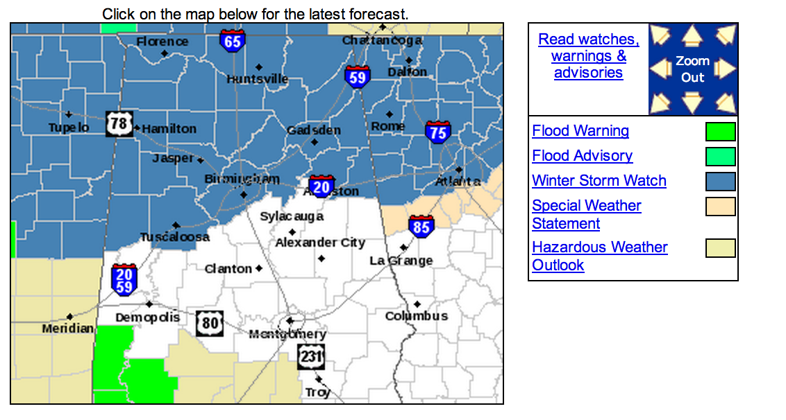
A Winter Storm Watch is in effect for areas generally along and north of I-20. The watch includes Tuscaloosa, Birmingham, Anniston, and points north.
In the text of the watch, the NWS mentioned potential for possible snow/sleet accumulation of over two inches, with potential ice accumulation of 1/4″.
TIMING: The main window for wintry precipitation will come from 6:00 p.m. tomorrow through 11:00 a.m. Tuesday.
PRECIPITATION TYPE: This is high resolution RPM model output, valid at 7:00 a.m. Tuesday…

I think this depiction is pretty close to reality after a review of forecast soundings; it should be all snow along and north of U.S. 278, or north of a line from Hamilton to Cullman to Gadsden. Down along the I-20 corridor, this is a very hard call as a warm nose of air around 5,000 feet will be moving in from the south. This means a “wintry mix” of sleet, freezing rain, and snow.
Freezing rain is the last thing we want; that is rain that falls in liquid form with temperatures at or below freezing. This, in turn, can coat exposed objects with ice. This is the WPC probability of ice accumulation beginning Tuesday morning at 6a CT

Ice accumulation as we all know can be enough to bring down trees and power lines if freezing rain rates become high enough.
Below is output from the European global computer model, depicting snow/ice accumulation through Tuesday evening…

I think snow totals on this run are overdone, but the placement looks good, and in line with the forecast.
ACCUMULATION POTENTIAL: Here is a first projection of what to expect…

IMPACT: Accumulation of ice/snow will bring deteriorating road conditions to North Alabama Monday night, possibly as early as 6:00-8:00 p.m. Monday. But, the main issues will come after midnight Monday night into the morning hours Tuesday. Bridges and overpasses initially will become icy and slick, and where precipitation is heavier all road surfaces will become dangerous. There is a good chance that Tuesday will be a “snow day” for much of North Alabama with many closings. Those decisions, of course, won’t be made until tomorrow.
For Tuscaloosa, Birmingham, Anniston, and maybe Gadsden, there could be more ice than snow, and while I would say it is not likely, there could be enough ice accumulation for some tree and power line damage. I would be prepared for power outages just in case.
The good news is that temperatures will be not in the 18-22 degree range like the snow event here January 28, so there is no comparison to the two situations. They are both significant, but different.
Another wave will bring rain to the state Tuesday evening into Wednesday, this should “wash away” what snow accumulates pretty quickly as thermal profiles become warmer across Alabama. Meaning, a decent chance life gets back to normal to some degree on Wednesday.
CONFIDENCE: Confidence in the large, synoptic scale is high. The hardest part of the forecast is on the southern periphery of the watch area. A few miles will mean the difference between a cold, rainy day, and a big ice/snow problem that shuts travel down completely. And, this boundary will be right over the larger cities in North-Central Alabama. Yes, it is possible Birmingham, Tuscaloosa, and Anniston could have just a cold rain, but with potential for a significant ice/snow so close, the NWS did the right thing by pulling the Winter Storm Watch southward overnight to include the big cities.
REMEMBER: I say this with every winter weather forecast we issue, and will say it again here. With any winter storm threat in Alabama, expect surprises. The forecast is always fluid, and you need to stay in touch with us for changes as we get closer to the event. There will be many updates here, and we thank you for taking the time to read them. Stay tuned…
Category: Alabama's Weather
About the Author (Author Profile)
James Spann is one of the most recognized and trusted television meteorologists in the industry. He holds the AMS CCM designation and television seals from the AMS and NWA. He is a past winner of the Broadcast Meteorologist of the Year from both professional organizations.Subscribe
If you enjoyed this article, subscribe to receive more just like it.


