GFS Data In
The 0z run of the GFS is in and it still shows strong indications of a decent icing event in the I-20 corridor Tuesday morning with a decent accumulating snow just to the north.
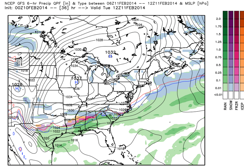
Here is the precipitation type output from the GFS between midnight and 6 a.m. Tuesday morning:
It could begin as a sleet and freezing rain mix late tonight in Marion and Lamar Counties.
There could be a significant glaze Tuesday morning in places like Pickens, Tuscaloosa, Jefferson, northern Shelby, St. Clair and Calhoun Counties.
Just north of this, across Lamar, Marion, Winston, Walker, Cullman, Blount, Marshall, Etowah and Cherokee Counties, the precipitation should be a mix of sleet, freezing rain and snow, but leaning more heavily to snow. Even extreme northern Jefferson County could see more snow. 1 to 3 inches of snow may accumulate.
There will be travel problems across much of the area outlined above late Monday night into Tuesday morning. The hazardous conditions will exist in some areas until at least Tuesday afternoon.
To the south of this area, the precipitation will be mostly rain, although there could be some sleet or freezing rain mixed in.
A winter storm watch remains in effect for Blount, Calhoun, Cherokee, Cleburne, Etowah, Fayette, Jefferson, Lamar, Marion, Pickens, St. Clair, Tuscaloosa, Walker and Winston Counties.
The NWS will post a winter storm warning for all or parts of the current winter storm watch area early Monday morning, before you wake up. In fact, many of your Weatheradios and apps will sound early tomorrow morning with the warning.
The precipitation should slowly transition to rain during the day on Tuesday if things hold according to the GFS. Parts of Northeast Alabama will stay colder and could see more snow.
The precipitation should move east out of the area Tuesday afternoon. Temperatures will drop to near freezing overnight Tuesday night, even as another wave of low pressure moves toward the area. More precipitation will arrive Wednesday morning during the predawn hours over western sections and spread eastward during the day.
It should start out as rain in the I-20 corridor, with some pockets of freezing rain possible in isolated areas. Over Northeast and East Alabama in places like Fort Payne, Gadsden and Anniston, it may be mostly freezing rain or sleet, changing to snow by afternoon. The snow will develop southwestward during the afternoon into Jefferson, Fayette and Walker Counties. A mix of snow and freezing rain will push southeastward Wednesday evening. The best chance for additional accumulating shows Wednesday afternoon and evening will be over East Alabama.
Travel may again become a real problem Wednesday in areas that see freezing rain or snow.
James will have an updated forecast first thing in the morning and we will be tracking the system continuously here until it is out of the area.
Category: Alabama's Weather, Winter Weather
About the Author (Author Profile)
Bill Murray is the President of The Weather Factory. He is the site's official weather historian and a weekend forecaster. He also anchors the site's severe weather coverage. Bill Murray is the proud holder of National Weather Association Digital Seal #0001 @wxhistorianSubscribe
If you enjoyed this article, subscribe to receive more just like it.


