Winter Weather Advisory For North Alabama
An all new edition of the ABC 33/40 Weather Xtreme video is available in the player on the right sidebar of the blog. You can subscribe to the Weather Xtreme video on iTunes by clicking here.
MESSY WINTER WEATHER PATTERN: We will have two waves of precipitation across the Deep South this week, as a cold, unsettled pattern develops. Take some time to watch the Weather Xtreme video for all of the maps and graphics.
First off, we will focus on “round one”. An impulse in the southern branch of the jet stream will bring precipitation to Alabama tonight, and during the late night hours into tomorrow morning, a “wintry mix” will develop”. The NWS has issued a “winter weather advisory” for that part of Alabama along and north of I-20. Basically including Tuscaloosa, Birmingham, Anniston, and points north.
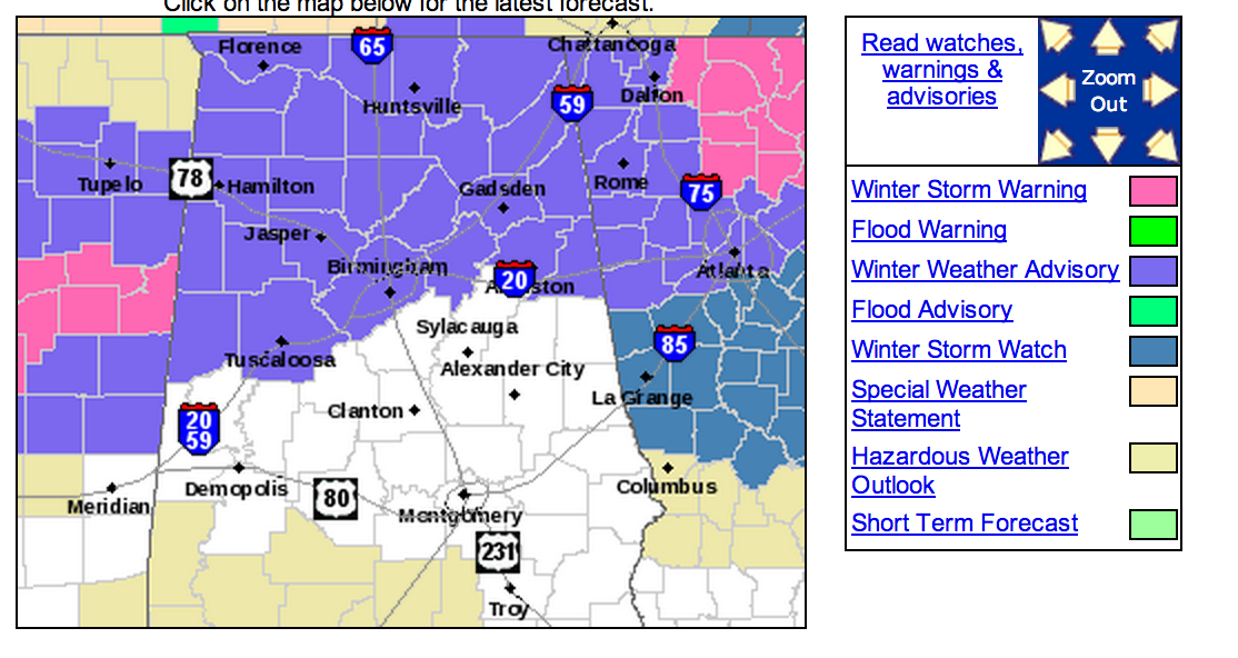
TIMING: We expect no travel issues during the day today, and no travel issues tonight through midnight. The core potential for bridge/overpass icing is from 2:00 a.m. until 11:00 a.m. tomorrow, although isolated icy patches could linger past 11:00 in some parts of North Alabama. Temperatures will rise above freezing in most places by mid-morning.
PRECIPITATION TYPE: The best chance of snow is north of Birmingham, especially along the U.S. 278 corridor (Hamilton to Cullman to Gadsden). Along I-20, the main threat is from sleet and freezing rain (freezing rain is rain in liquid form that falls with surface temperatures are at or below 32 degrees).
PRECIPITATION AMOUNT: The models have trended drier over the past 12 hours, and that is a very good thing. One reason the NWS issued a “winter weather advisory” instead of a “winter storm warning”. Some of the better mesoscale models are actually showing very little snow accumulation now for North Alabama, but I do think one inch of snow is possible near U.S. 278. Maybe two inches in isolated spots.
The biggest threat is from freezing rain. Up to 1/4 inch of ice is possible, and this is significant.
IMPACT: Bridges and overpasses will become icy early tomorrow where temperatures drop to the freezing mark, and that is possible as far south as I-20 leading to hazardous driving conditions. Many of the road surfaces will remain wet (thankfully we had a very mild day yesterday), but icy spots are very possible.
If there are places with 1/4″ of ice, then scattered power outages are possible due to falling tree limbs and branches. For now I don’t expect widespread, or especially long lasting power outages, but if the freezing rain is heavier than forecast, that will change.
UNCERTAINTY: The NWS “ice accumulation” map has the magic blue line, where icing begins, right at Tuscaloosa, Birmingham, and Anniston.
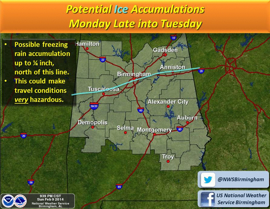
Errors in the 30-40 mile range are possible here, meaning the larger cities of Birmingham, Tuscaloosa, and Anniston could get away with just a cold, rainy day with no ice. Or, there could be significant bridge icing tomorrow morning very very hazardous driving conditions. As a course of least regret, you pretty much have to plan on freezing rain and bridge icing, and hope you get away with just a cold rain in these places.
We will keep the blog updated throughout the day, and we always caution you, the forecast can, and probably will change to some degree.
SECOND ROUND OF WINTRY WEATHER? Models are in good agreement that a surface low will form in the Gulf of Mexico by tomorrow night with good upper support. And, to make matters really complicated, a strong cold air damming pattern (the wedge) will send very cold air at the surface down through North Georgia and into East and Northeast Alabama. This could lead to a very significant icing situation over these places; I have great fear a big ice storm is a distinct possibility for Atlanta in this setup.
Here in Alabama, the highest risk of freezing rain and ice will come for counties like Jackson, Cherokee, Marshall, Etowah, Calhoun, Cleburne, and Randolph where temperatures could drop into the 28 to 32 degree range late tomorrow night into Wednesday morning with freezing rain and perhaps a few snow flakes.
For most of Alabama away from the CAD setup (counties mentioned above), it will just be a cold rain with the “second wave”.
We will focus much more on this situation later today and tomorrow morning.
IMPROVING WEATHER, FINALLY: We will enjoy clearing sky Thursday with a high around 50 degrees as the storm system moves northeast, away from Alabama. Friday will be partly sunny with a high in the mid 50s.
MILD WEEKEND: How about highs in the 60s this weekend. Looks delightful with a good supply of sunshine Saturday and Sunday as icy memories fade.
Again, I encourage you to watch the Weather Xtreme video for the maps, graphics, and more details.
WEATHER BRAINS: Don’t forget you can listen to our weekly 90 minute netcast anytime on the web, or on iTunes. This is the show all about weather featuring many familiar voices, including our meteorologists here at ABC 33/40.
CONNECT: You can find me on all of the major social networks…
Facebook
Twitter
Google Plus
Instagram
I will do a weather program this morning at Clay Chalkville Middle School before heading in to the weather office at ABC 33/40. I will have a full discussion and Weather Xtreme video here by 4:00… Bill Murray and Ryan Stinnett will have updates between now and then. Stay tuned and enjoy the day!
Category: Alabama's Weather
About the Author (Author Profile)
James Spann is one of the most recognized and trusted television meteorologists in the industry. He holds the AMS CCM designation and television seals from the AMS and NWA. He is a past winner of the Broadcast Meteorologist of the Year from both professional organizations.Subscribe
If you enjoyed this article, subscribe to receive more just like it.


