Morning Update
As we wait for this winter weather system to develop and begin to impact the area, we are still pouring over model data. The 0Z runs of the models came in drier and were the main reason some accumulation totals were brought down a bit. The 6Z data, came in a tad bit wetter. We are waiting in the 12Z data that will hopefully provide us a better forecast and understanding of this system.
For today, we are watching both our temperatures as well as the radar carefully.
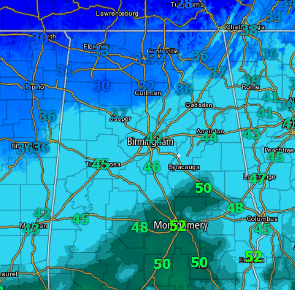
TEMPS: All of Central Alabama is above freezing this morning. Any precip that falls in these areas today will fall in the form of rain. Our temps will approach the freezing mark overnight and that is when we will see the switch over to sleet and snow over northern portions of the state. You will be fine today and no issues with travel are expected in the area. We do note locations in the Tennessee Valley this morning are at or just below the freezing mark and there have been a few reports of some icing up that on elevated surfaces. That was expected, and throughout the day for areas along and north of U.S. 278, there will be a light wintry mix.
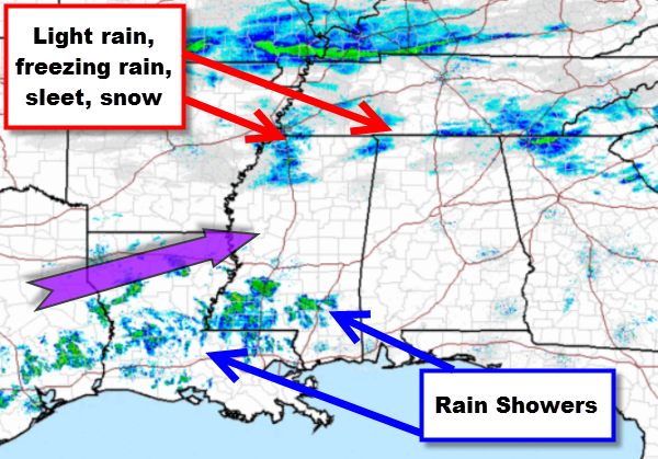
NOW THE RADAR: We will see our moisture levels increase today and additional showers will begin to overrun the state. With our temps being well above freezing today, there should be no problems with ice. The main threat for the change to freezing precip will be overnight. Just expect a cold rain to fall today. As we look at the regional radar, we are seeing showers increase to our southwest. Those will be heading into Alabama later today.
NEW MODEL DATA: The next runs of the model will be completed during the next couple of hours and those will certainly help us formulate our midday update. The overnight runs did not show much change in the location and timing. As rain moves in and temps fall overnight, we will see sleet and snow develop north of Intestate 20. Along the Interstate 20 corridor is the trickiest forecast. It still appears that freezing rain and icing will be the major issue.
TIMING: The Winter Weather Advisory for the areas is valid from 6 PM this evening until 6 PM Tuesday evening. Rain showers will be increasing across the area today. After midnight we should begin to see the frozen precip fall. By tomorrow morning we expect all of Central Alabama to be receiving precip. I urge people to not plan on going anywhere tomorrow morning.
This is a very challenging forecast, because the most populated part of the state is right along where the most uncertainty is with this event. Temperatures along I-20 will be right around the freezing mark and a few miles could determine whether you will be receive all rain or will be getting a significant glazing of ice.
Category: Alabama's Weather, Winter Weather
About the Author (Author Profile)
Macon, Georgia Television Chief Meteorologist, Birmingham native, and long time Contributor on AlabamaWX. Stormchaser. I did not choose Weather, it chose Me. College Football Fanatic. @Ryan_StinnetSubscribe
If you enjoyed this article, subscribe to receive more just like it.


