

7:00 am Update
The forecast is right on track this morning with significant accumulating snows in North Alabama generally along US-278. Freezing rain is occurring down to I-20. Exposed surfaces are glazed in this area and bridges will be icy in spots. Schools are closed across much of the area and not many people are on the roads across North and North Central Alabama. If you can stay put this morning, do so.
NORTH ALABAMA
Roads are slick to impassable and travel is not recommended. Temperatures are in the middle and upper 20s and won’t go above freezing in many areas. Winter storm warning in effect for Cullman, De Kalb, Jackson, Lawrence, Marshall and Morgan Counties in Alabama until noon. A winter weather advisory is in effect for Colbert, Franklin, Lauderdale, Limestone and Madison Counties.
* Light snow at Huntsville, Fort Payne, Cullman and Haleyville. 23F at Haleyville with snow covered roads.
* 3.5 inches of snow in Arab. Roads in Marshall County are very dangerous.
* 2″ in Holly Pond according to Bob Kusz with numerous wrecks reported on scanner
* 1-2″ in Hartselle, still snowing.
* Skycam shows good accumulations in Hamilton
* 1″ around Huntsville
* Roads are a “solid sheet of ice” around Athens
* 2″ around Vinemont in Cullman County
* 1″ of snow at Sand Rock in Cherokee County
* No snow or sleet accumulations in Jasper, but 32F with light freezing rain.
* I-65 NB was reported at a standstill north of Cullman between Vinemont and Falkville.
NORTH CENTRAL ALABAMA
Here is the radar at 7 a.m. with some recent freezing rain reports from the NWS:
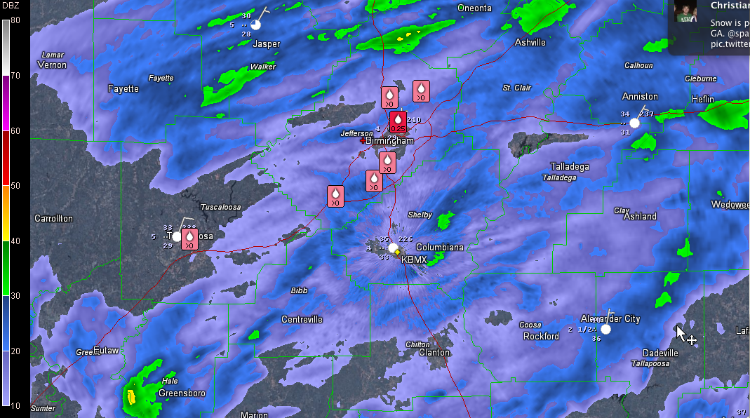
Temperatures fell to 32F at the BHM Airport around 5 a.m. Still 32F at 6 a.m. It is 34F in Anniston. 35F at Calera.
In Tuscaloosa, the official reading at the airport was 34F but it is below freezing at our Skycam location in downtown. Starting to get reports of freezing rain resulted in icing on exposed surfaces in the city.
Winter storm warning remains in effect for Blount, Calhoun, Cherokee, Cleburne, Etowah, Fayette, Jefferson, Lamar, Marion, Pickens, St. Clair, Tuscaloosa, Walker and Winston Counties until late Wednesday night.
* Starting to see a light glaze developing on exposed surfaces in areas where temperatures are at or below freezing. This makes for dangerous conditions if you try to walk outside. Falls will be common. Don’t end up in the ER.
* Bridges will begin to ice soon in areas at or near 32F.
* Trees are iced in Hueytown (31F) according to John Talbot.
* Similar reports from McCalla and Gardendale with exposed surfaces glazed.
* Freezing rain with a glaze on exposed surface and roads in Fayette.
Stay put if you can and wait to see if temperatures warm above freezing later this morning across the I-20 corridor. That should occur by 10 .m. in the I-20 corridor.
SOUTH CENTRAL ALABAMA
A winter weather advisory continues for Bibb, Clay, Greene, Hale, Randolph, Shelby, Sumter and Talladega Counties.
From Eutaw and Demopolis to Centreville, on across Shelby County into Talladega and over to Roanoke, temperatures are generally in the middle 30s, with isolated spots near freezing. I saw a report of 32F near Jemison. Bridges and overpasses may become icy in spots.
Use extreme caution if you must travel in these areas, and just stay put until mid-morning if you can.
FLIGHTS
* Many flights canceled out of ATL, CLT and DFW and this is impacting flights from the Birmingham Shuttlesworth International Airport. Check with your airline if you have a flight.
Category: Alabama's Weather, Winter Weather
About the Author (Author Profile)
Bill Murray is the President of The Weather Factory. He is the site's official weather historian and a weekend forecaster. He also anchors the site's severe weather coverage. Bill Murray is the proud holder of National Weather Association Digital Seal #0001 @wxhistorianSubscribe
If you enjoyed this article, subscribe to receive more just like it.


