

Important Notes On Round Two
*The first wave of wintry precipitation behaved as forecast across Alabama last night and this morning. Snow for the U.S. 278 corridor, freezing rain/ice down to I-20, a cold rain below I-20. Heavier snows were over parts of Morgan, Cullman, Marshall, and DeKalb counties. Some 5 inch totals have been reported there.
*A very dynamic wave will generate a surface low on the old front in the northern Gulf of Mexico late tonight, and will spread rain back into Alabama tonight.
*Cold air damming (CAD) will bring colder air down into Northeast and East Alabama tonight and tomorrow. Computer models rarely handle CAD situations well, and it is often much colder than you might think over some East Alabama counties after a review of model data.
*The CAD situation will make for yet another challenging forecast. You will want to keep a close eye on the blog for updates over the next 36 hours.
*We will have a lull in the precipitation across Alabama this afternoon, but a large mass of rain moves back into the state tonight. We will monitor the northern counties for temperature trends, but it looks like a majority of the state will have just a cold rain tonight.
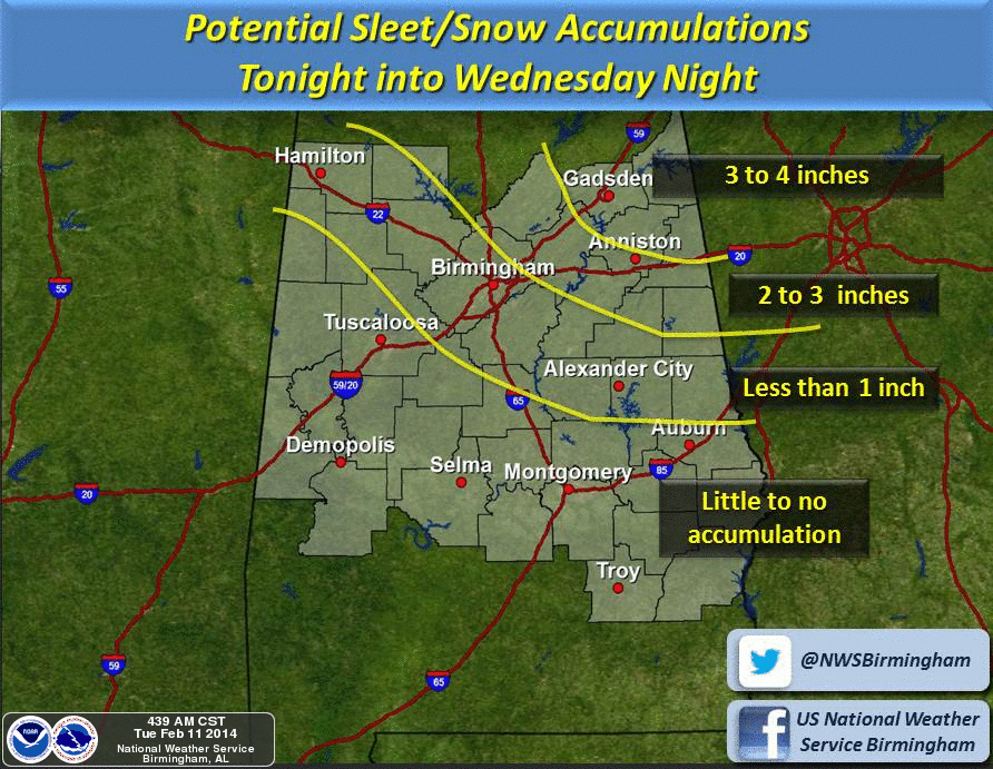
*Tomorrow, as colder air drains into Northeast Alabama, and dynamic cooling begins, rain will likely change to snow during the day, mainly over Northeast Alabama, with the rain-snow line moving southwest during the afternoon. This is the NWS snow projection…
*Snow is possible over Northeast Alabama during the pre-dawn hours tomorrow. If there is snow in the Birmingham metro, it won’t happen until late morning or early afternoon, and there is a real chance it will be just a cold rain through the entire event in Birmingham.
*I also am concerned about ice accumulation over Cleburne, Randolph, Chambers, and Lee counties in East-Central Alabama. CAD setups often bring very cold air into this part of the state, and with so much rain there is a chance significant ice accumulation could happen. But, we all know the difference in a degree or two makes the difference between a cold, rainy day and a nasty ice situation. It is a very close call for these counties.
*This has the potential to be a crippling and historic ice storm for Atlanta and much of North and Central Georgia. Extended power outages are likely, and people there need to rush preparations to completion for a devastating ice storm. Much of South Carolina will also go on ice, including places like Columbia.
*West Alabama should have just a soaking, cold rain with “round two”. Places like Tuscaloosa, Greensboro, Eutaw.
Much more as the day rolls along… stay tuned…
Category: Alabama's Weather
About the Author (Author Profile)
James Spann is one of the most recognized and trusted television meteorologists in the industry. He holds the AMS CCM designation and television seals from the AMS and NWA. He is a past winner of the Broadcast Meteorologist of the Year from both professional organizations.Subscribe
If you enjoyed this article, subscribe to receive more just like it.


