Major Winter Storm To Impact Alabama
Get ready for “phase two” of the dual barrel winter storm impacting the southern U.S.
Winter storm warnings are up for much of North and East Alabama late tonight and tomorrow…
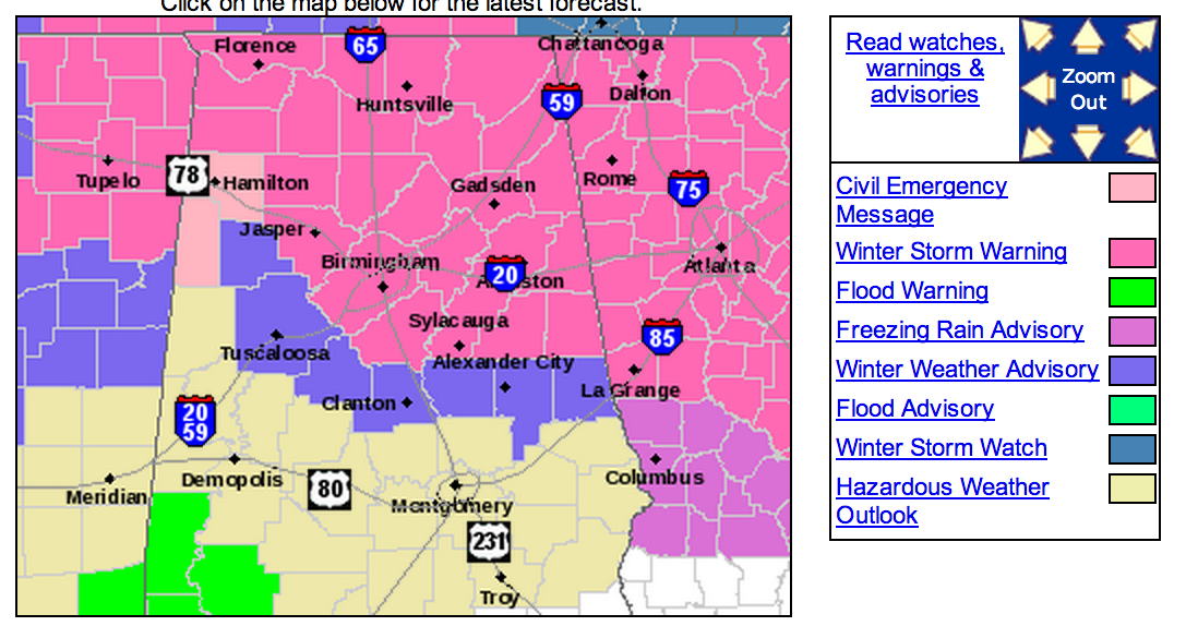
The highest impact of this second phase will be east of a line from Hamilton to Birmingham to Lafayette.
SNOW: Heaviest snow in Alabama will come over the northeast counties of the state, where amounts in the 2 to 4 inch range are possible north and east of Gadsden. We note the National Weather Service in Huntsville is going to mention 5 to 8 inches of snow up in the Tennessee Valley for Madison, Jackson, Marshall, and DeKalb Counties. This is a major winter storm.
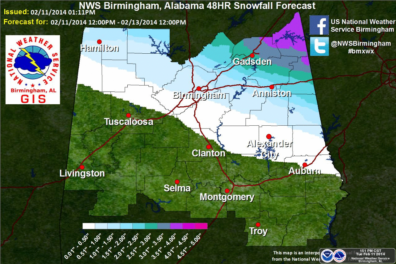
Snow amounts taper off to a dusting to one inch from Fayette to Birmingham to Alex City. The heavier snow amounts will be north and east of Birmingham. Tuscaloosa will have mostly a cold rain.
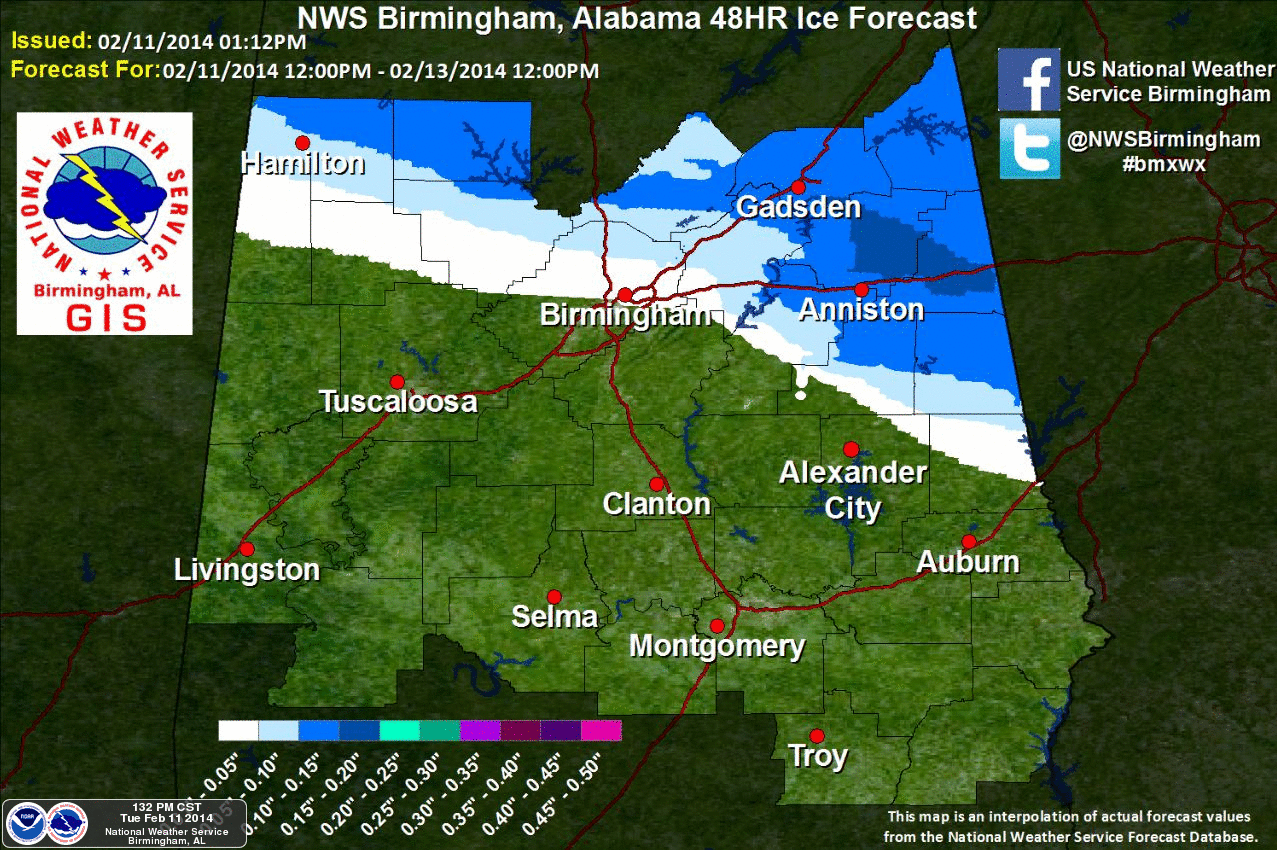
ICE: Freezing rain could bring ice accumulation of over .20″ to parts of East Alabama.
TIMING: A large mass of rain will move into Alabama tonight. Initially, the best chance of any freezing or frozen precipitation will come north of U.S. 278 (Hamilton to Gadsden to Cullman) tonight, perhaps as early as 9 p.m. to midnight, where a mix of freezing rain, sleet, snow, and rain is possible. For many places south of U.S. 278, it will be mostly a cold rain during the night with temperatures in the mid 30s.
Colder air will move into Alabama from the northeast due to the cold air damming (CAD) effect, and the precipitation will change all snow during the day tomorrow. The rain/snow line will most likely move from northeast to southwest. Calling the exact time of the change is very difficult, but for Birmingham it could be midday before it happens. The precipitation much of the day will be snow or freezing rain for cities to the east like Anniston and Gadsden.
THURSDAY: The weather improves, but temperatures will be below freezing Thursday morning, and travel still could greatly impacted across North and East Alabama.
IMPACT: Snow, sleet, and freezing rain will make for dangerous driving conditions again. Initially on bridges and overpasses, but major and secondary roads will become icy and dangerous as well as the precipitation increases through the day tomorrow.
I am also concerned about ice accumulation over East-Central Alabama counties like Calhoun, Cleburne, Randolph, Clay, and Chambers. CAD patterns like this can bring very cold surface temperatures into Alabama from the east, this is where some power outages are possible. I would have enough supplies/medicine for a day or two if you are in this area.
IMPORTANT POINT: This “phase two” event is more dynamic than the first one, and will have the potential for very significant winter weather to parts of North and East Alabama late tonight and tomorrow. No, this is no “Blizzard of 93”, but it is a similar type storm that will have very high societal impacts for the Southeast U.S. The National Weather Service, in describing the ice/snow potential from Atlanta to Raleigh, is using words like “paralyzing,mind-boggling, and historic” in describing the storm. A crippling ice storm is likely from Atlanta to Augusta to Columbia (SC) east of Alabama.
Be ready for forecast changes and updates as we get into this. I will almost guarantee you there will be surprises, and if anything we might be under forecasting the event over East and Northeast Alabama.
TO THE SOUTH AND WEST: It will be a cold, soaking rain for South Alabama, and much of West-Central Alabama.
UNCERTAINTY: Like “phase one”, calling the southern periphery of the ice/snow is the hardest call here. The NWS has issued a “winter weather advisory for Bibb, Chambers, Chilton, Coosa, Tallapoosa, and Tuscaloosa Counties, but this is in the boundary zone, and understand these counties could see either a cold rain, or some ice/snow. Even Birmingham very close to the boundary; Bessemer could wind up with a cold rain, while Trussville has two inches of snow. A 30-40 mile error is very possible on the southern flank of the freezing/frozen precipitation.
We will have frequent updates as we go through this event together, so stay tuned. The good news is that we warm up this weekend, with 60s possible by Sunday….
Category: Alabama's Weather
About the Author (Author Profile)
James Spann is one of the most recognized and trusted television meteorologists in the industry. He holds the AMS CCM designation and television seals from the AMS and NWA. He is a past winner of the Broadcast Meteorologist of the Year from both professional organizations.Subscribe
If you enjoyed this article, subscribe to receive more just like it.


