Winter Storm Warning North/East Alabama
**I will begin producing the Weather Xtreme video tomorrow; holding production again today so we can get text products out quickly and do social media response**
MAJOR WINTER STORM TO IMPACT ALABAMA: The forecast is on track from yesterday, and there is no real need for much modification today. A cold rain has been falling over Alabama overnight. Temperatures are above freezing this morning, and there are no travel issues other than wet roads.
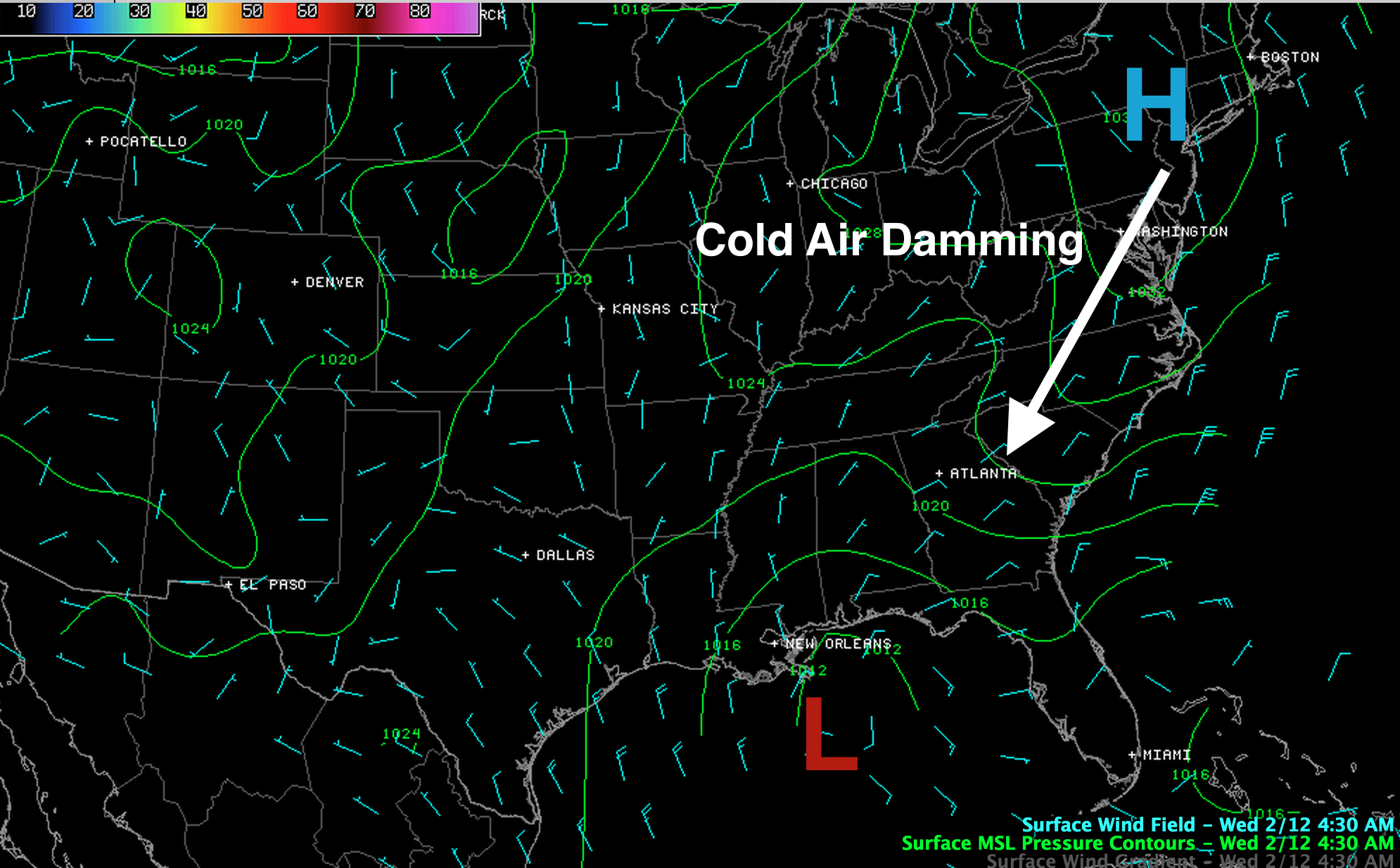
A classic winter weather pattern is in place, with a cold high to the northeast, and a low forming in the northern Gulf of Mexico.
The NWS maintains a winter storm warning east of a line from Hamilton to Jasper to Birmingham to Sylacauga to Roanoke for today and tonight.
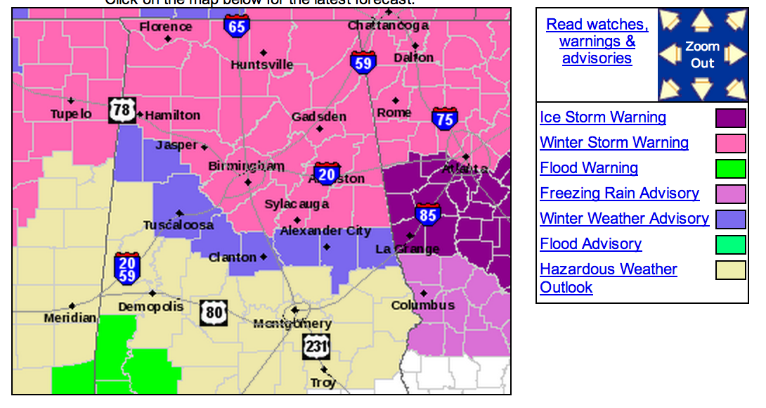
There is a “winter weather advisory” for places like Tuscaloosa, Brent, Clanton, and Rockford, but mostly rain is likely there. That is a buffer zone.
TIMING: Here is output from our high resolution RPM model, which shows the change from rain to snow. The first graphic is output valid at 1:00 p.m. CT.
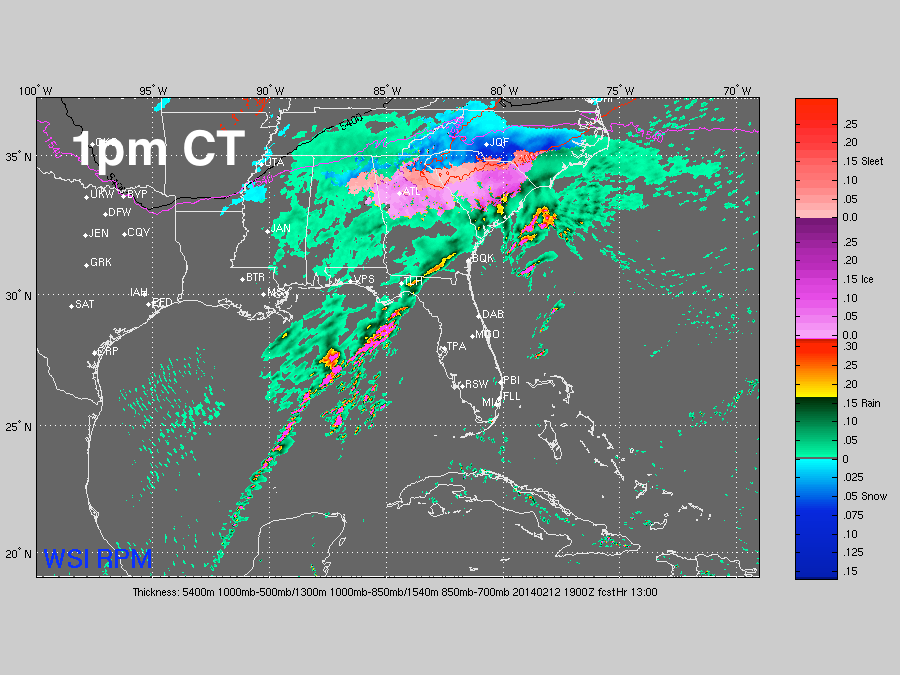
The change to snow and freezing rain should begin in the 12:00 noon to 1:00 p.m. time frame north of U.S. 278 (Hamilton to Cullman to Gadsden), and east of U.S. 431 (Gadsden to Anniston to Roanoke). Bottom line is that we will still have mostly a cold rain and temperatures above freezing through 12:00 noon. After that, temperatures begin to fall, and conditions will begin to deteriorate.
RPM output valid at 4:00 p.m CT…
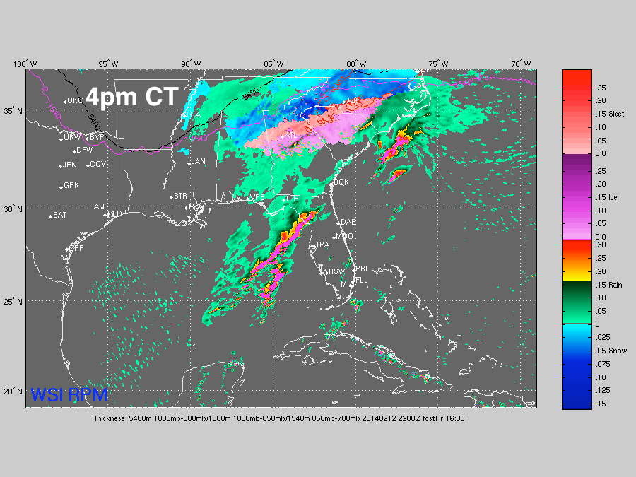
At this point, snow should be widespread from Birmingham north and east as dynamic cooling kicks in from the storm, and cold air continues to be pulled into the state at the surface from the east. A band of freezing rain/ice is likely over East Alabama below the snow.
And, RPM output valid at 7:00 p.m CT…
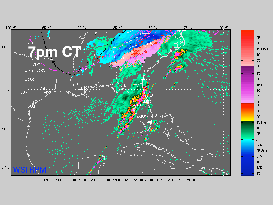
Snow continues from Birmingham north and east, with freezing rain to the south over counties like Randolph, Clay, and Chambers.
PRECIPITATION TOTALS: Here is the NWS snow accumulation projection…
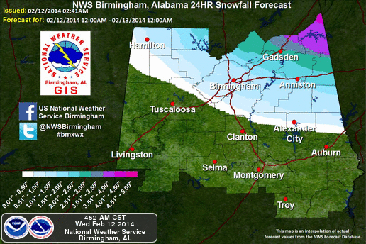
Heaviest snow will come over Northeast Alabama… some communities in Jackson and DeKalb could see 3-5 inches of snow. Gadsden around 2 inches… 1-2 inches near Anniston. Birmingham remains right on the line between rain and snow; some of the northeast suburbs could see an inch or two, but just southwest of Birmingham it will be a cold rain.
Just rain, generally speaking, for places like Tuscaloosa, Greensboro, Clanton. However, some snow is not out of the question as it all winds down later today.
IMPACT: As temperatures fall this afternoon, driving conditions will become hazardous due to snow and freezing rain. Initially roads and bridges will be the issue, but black top roads could also have ice and snow issues as well, especially after dark as temperatures continue to drop. I believe the “afternoon drive” period today (3-6 p.m.) will be very challenging to snow and ice from Birmingham north and east.
I also have concern there could be enough ice accumulation over some East-Central Alabama counties for scattered power outages. Counties like Cleburne, Randolph, Clay, and Chambers. This is where the “wedge” comes into play… cold air drains into our state from Georgia. They go below freezing with rain still falling.
TO THE EAST: A crippling ice storm is still expected over much of Central Georgia and South Carolina.
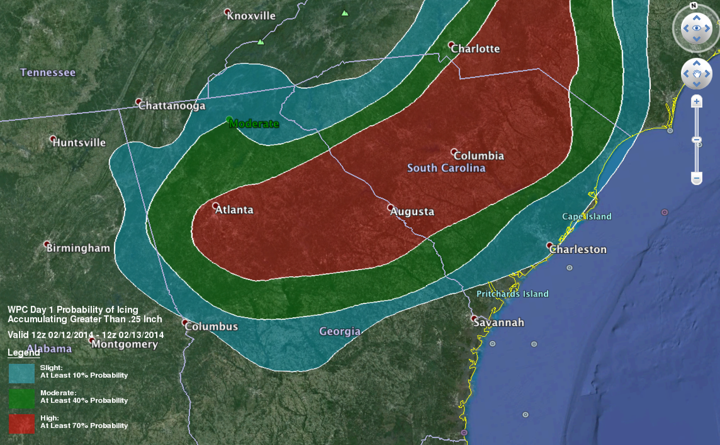
An ice storm warning is up for of Central Georgia, from Atlanta south toward Macon. Power outages there could be widespread, and last for days.
TONIGHT/TOMORROW MORNING: The snow will end across Alabama in the 9:00 p.m. to midnight time frame tonight. Temperatures go down into the 20s, and icy travel is likely through tomorrow morning where snow falls today and tonight. Road conditions there will begin to improve by late morning.
GOOD NEWS: The weekend ahead will be dry and warmer; the high will be in the low 50s Saturday, and low 60s Sunday.
WEATHER BRAINS: Don’t forget you can listen to our weekly 90 minute netcast anytime on the web, or on iTunes. This is the show all about weather featuring many familiar voices, including our meteorologists here at ABC 33/40.
CONNECT: You can find me on all of the major social networks…
Facebook
Twitter
Google Plus
Instagram
Stay tuned to the blog today for frequent updates…
Category: Alabama's Weather
About the Author (Author Profile)
James Spann is one of the most recognized and trusted television meteorologists in the industry. He holds the AMS CCM designation and television seals from the AMS and NWA. He is a past winner of the Broadcast Meteorologist of the Year from both professional organizations.Subscribe
If you enjoyed this article, subscribe to receive more just like it.


