Why It Will Snow in North Central Alabama This Afternoon
It’s a dreary cold day across Central Alabama.
Temperatures in the I-20 corridor range from 41F at Tuscaloosa to 37F at Birmingham, to 38F at Celera to 35F at Anniston. Weather stations in eastern Jefferson County and western St. Clair County, like Center Point, Leeds, moody and Odenville are showing 34-35F.
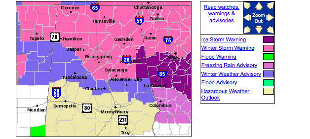
Colder air continues to flow into eastern Alabama on the back of the appropriately named “Polar Wedgie.” A shout out to Charles Daniel from our team for introducing the term. It is now 32-33F across Cleburne and Randolph Counties where a serious icing situation is setting up. Ice storm warnings are issued for these two counties earlier. The Weather Service may choose to add additional counties to the ice storm warning soon.
In addition, there is increasing confidence that a significant accumulating snow will impact much of North and Central Alabama this afternoon and tonight.
The Winter Weather Advisory has been extended to include Pickens County.
Here are the current warnings and advisories:
But that is separate from what will happen to cause heavy snow over North Central Alabama this afternoon and evening.
Here is the setup:
An upper level low is located over Central Mississippi this morning. It is moving eastward.
A deformation zone sets up on the northern edge of these 850 mb lows. I’ve drawn it for you here.
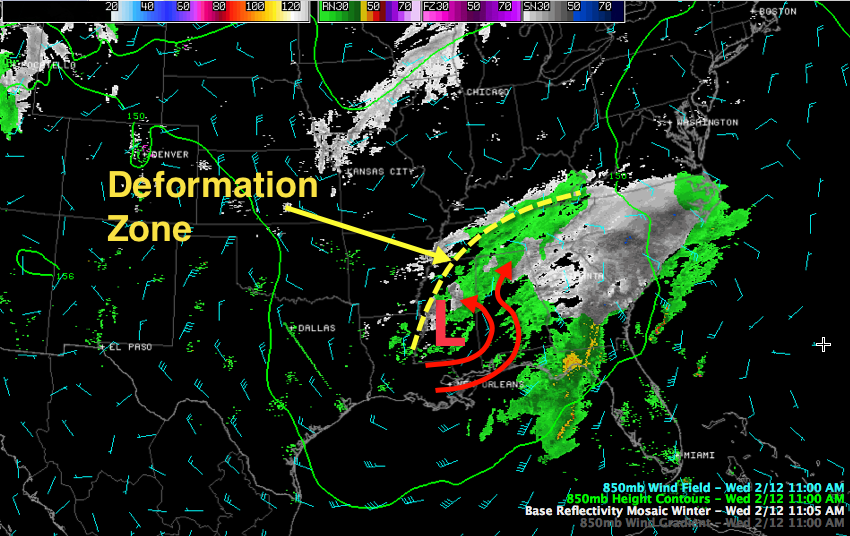
Moist air circulates around the low. Some continues to wrap around it to the left while some of it splits and is shunted to the right. You can see the radar returns just to the south of it.
As this low heads eastward, this zone of enhanced upward motion will pivot across Central Alabama setting up a band of heavier snow.
From the NWS:
BASED OFF THE LATEST SUITE OF MODELS IT APPEARS THE DEFORMATION BAND WILL SET UP ALONG AND JUST NORTH OF THE
I-20/59 CORRIDOR. BASED ON THE LATEST MODEL GUIDANCE WILL MORE THAN LIKELY BE INCREASING SNOWFALL TOTALS THIS AFTERNOON AND
EXTENDING THE ADVISORY AND WARNING BACK TO THE SOUTH AND WEST. THE LATEST 12Z GFS INDICATES A MODERATE TO HEAVY SNOW SOUNDING OVER METRO BIRMINGHAM AROUND 00Z TONIGHT. EXPECT THIS TYPE OF SETUP WOULD BE ABLE TO DROP A QUICK 2-3 INCHES OVER THE METRO AREA LATER THIS EVENING.
There is a lot of warm air aloft right now, but that will be cooled by dynamic processes and should be erased from the northeast through the afternoon.
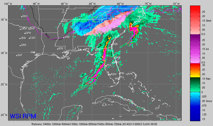
Here is a noon look at the precipitation forecast from the RPM:
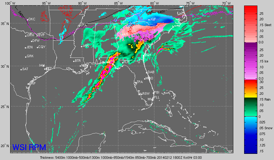
Here is the same look at 2 p.m. You can see snow breaking out (the blue color) over North Central Alabama, with significant icing continuing in East Central and North East Alabama. Snow could begin in the immediate Birmingham area as early as 3 p.m.
By 5 p.m., the changeover to snow is widespread across North Central with heavy snow falling in places like Jefferson and Shelby Counties, working down toward Tuscaloosa. The warning and advisory might have to be extend and west says the NWS because of increase snowfall amounts. The snow will accumulate quickly and roads will become hazardous in a short period.
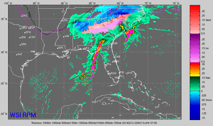
By 6 p.m. here is the predicted precipitation:
The snow should begin ending from the northwest by 10-11 pm.. It should end in the Birmingham area by 2-3 a.m. and be out of the area completely before sunrise.
BOTTOM LINE – PLAN NOW!
There is still a high likelihood that we will deal with a significant accumulating snowfall across a good bit of North Central Alabama late this afternoon and tonight. Accumulation forecasts are being updated now.
Many businesses and organizations are closing at 2 p.m., some at 3 p.m. Others at 1 p.m. But the overriding message is to be where you want to be shortly after 3 p.m. if you work or live in the Birmingham Metro area. Make your plan now and execute it.
SCROLL DOWN
For excellent posts by James and Ryan on this developing winter weather situation.
Category: Alabama's Weather, Winter Weather
About the Author (Author Profile)
Bill Murray is the President of The Weather Factory. He is the site's official weather historian and a weekend forecaster. He also anchors the site's severe weather coverage. Bill Murray is the proud holder of National Weather Association Digital Seal #0001 @wxhistorianSubscribe
If you enjoyed this article, subscribe to receive more just like it.


