Severe Storms Possible Thursday Night
An all new edition of the ABC 33/40 Weather Xtreme video is available in the player on the right sidebar of the blog. You can subscribe to the Weather Xtreme video on iTunes by clicking here.
FOGGY START: A dense fog advisory covers basically the northern half of Alabama this morning; some communities have visibilities down to only 1/4 mile. That fog will burn off by mid-morning, and the sky becomes partly sunny.
ON THE MAP: We have a nearly stalled surface front near U.S. 80. Drier air to the north, relatively moist air to the south of the boundary. The front will begin to work it’s way northward later today, and I think we will need to mention at least the chance of a shower in a few spots this afternoon and tonight. Nothing widespread or heavy, just the chance of a shower or two.
TOMORROW: The day will mostly cloudy and mild, and a few scattered showers are possible. The high will be in the upper 60s.
SEVERE WEATHER THREAT THURSDAY NIGHT: Thursday will be a warm and windy day; south winds of 12-25 will develop ahead of a dynamic weather system, and the GFS is printing a high of 76 degrees at Birmingham. If this verifies, it will be within two degrees of the record high for February 20 (78 set in 1986). A few showers could break out during the day, but the big event will come Thursday night.
SPC maintains the standard “slight risk” of severe weather for much of Alabama…
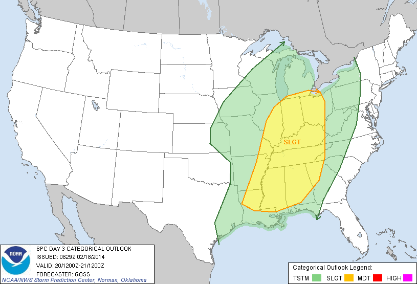
There is an enhanced 30 percent risk for that part of the state along and north of I-59.
TIMING: The main window for severe weather in Alabama will come from near 6:00 p.m. Thursday through 3:00 a.m. Friday.
MODES OF SEVERE WEATHER: The primary surface low will be over Lake Michigan, and the setup favors primarily the threat of strong, perhaps damaging straight line winds. The low level jet (5,000 feet) will feature winds of 50-70 knots over North Alabama, and it won’t take too much to bring this down to the surface with the stronger thunderstorms. This has the potential to knock down trees and power lines.
We should also note there is sufficient helicity in the low levels for a few isolated tornadoes where you see breaks or kinks in the squall line. But, clearly the biggest risk is from straight line winds with a linear band of thunderstorms.
Rain amounts of 1/2 to 1 inch are likely before the storms move out during the pre-dawn hours Friday.
FRIDAY AND THE WEEKEND: The sky becomes partly to mostly sunny Friday as drier air returns; the high Friday will be near 60 degrees. And, we are going with a dry weekend as the GFS has taken the idea of a surface wave in the Gulf of Mexico off the table. Expect a pretty decent amount of sunshine both Saturday and Sunday with early morning lows in the 30s, and afternoon highs in the 60-65 degree range.
NEXT WEEK: Still good evidence that much colder air will try to make a return appearance by the middle of the week; just how cold, and how long it lasts is still up for debate. Take some time to see the Weather Xtreme video for the maps, graphics, and details.
WEATHER BRAINS: Don’t forget you can listen to our weekly 90 minute netcast anytime on the web, or on iTunes. This is the show all about weather featuring many familiar voices, including our meteorologists here at ABC 33/40. Great to have Bill Bunting of the Storm Prediction Center on the show last night; scroll down for the show notes.
CONNECT: You can find me on all of the major social networks…
Facebook
Twitter
Google Plus
Instagram
Busy day ahead… I have weather programs today at Minor Community School in Jefferson County, and at Riverchase Elementary School in Hoover. Look for the next Weather Xtreme video here by 4:00 or so this afternoon. Enjoy the day!
Category: Alabama's Weather
About the Author (Author Profile)
James Spann is one of the most recognized and trusted television meteorologists in the industry. He holds the AMS CCM designation and television seals from the AMS and NWA. He is a past winner of the Broadcast Meteorologist of the Year from both professional organizations.Subscribe
If you enjoyed this article, subscribe to receive more just like it.


