Watching Storms to the West
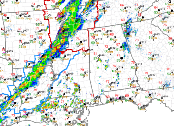
The line of storms along the cold front continues to develop and intensify this evening. Over the last hour, we have gone from couple of warnings to over a dozen, and that does include a few tornado warnings issued from the NWS Memphis Office.
All of northern Mississippi and west-central Tennessee remains under a tornado watch this evening. To the south and west of this area, a severe thunderstorm watch is in effect for Mississippi back into the eastern Texas.
There have been a few impressive tornado signatures on radar this afternoon and several reports of large hail as well as reports of damaging winds in areas being impacted by storms.
This line of storms will continue to move off towards the east as will begin to impact areas in Alabama after 6 PM this evening.
In Alabama, we have seen showers moving north today. Even this afternoon, as temps have warmed to near the 80 degree mark, we have seen the capping inversion over the state slowly erode, and that has allowed a few showers and storms to develop over Dallas, Perry, and Tuscaloosa counties. That inversion will continue to erode as better dynamics move into the state later this evening.
Expect the line of storms to sweep across the state between 6PM and 3AM for most locations in Central Alabama. We are expecting to see a severe thunderstorm or tornado watch issued later this evening for portions of Alabama.
Category: Alabama's Weather, Severe Weather
About the Author (Author Profile)
Macon, Georgia Television Chief Meteorologist, Birmingham native, and long time Contributor on AlabamaWX. Stormchaser. I did not choose Weather, it chose Me. College Football Fanatic. @Ryan_StinnetSubscribe
If you enjoyed this article, subscribe to receive more just like it.


