

Update for Northwest Alabama
A line of intense thunderstorms is now less than an hour away from the Northwest Alabama counties of Franklin, Marion and northern Lamar. The NWS Hunstville just issued a severe thunderstorm warning for Franklin and Colbert Counties in Northwest Alabama.
Strong storms are lined up now from Booneville to Tupelo to Houston in northeastern Mississippi. They are moving east northeast at 45 mph.
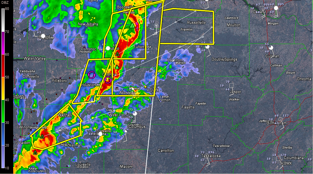
WTVA reported dime sized hail and 60 mph winds in Tupelo a short while ago with these storms.
The storms are associated with what appears to be a mesoscale convective vortex over northern Mississippi tonight. This is some spin in the middle atmosphere that can enhance severe weather chances.
Bulk shear increases rapidly just across the border in Alabama according to the SPC Mesoanalysis page. This is worrisome as the storms may be able to intensify further.
I am also concerned about the backed surface winds across North Alabama. Backed means they are backing counterclockwise around the compass rose, becoming more southeasterly. This increases the low level helicity and the potential for spin up tornadoes.
In addition, increasing mid level winds means the likelihood of damaging winds is increasing.
Right now, the lifted condensation level values near this activity is still a tad too high. But lower lifted condensation level air that is more favorable for possible tornadoes is streaming northward across West Alabama tonight. Between now and the hours after midnight, these conditions and the approaching storms may intersect to produce severe weather.
Category: Alabama's Weather, Severe Weather
About the Author (Author Profile)
Bill Murray is the President of The Weather Factory. He is the site's official weather historian and a weekend forecaster. He also anchors the site's severe weather coverage. Bill Murray is the proud holder of National Weather Association Digital Seal #0001 @wxhistorianSubscribe
If you enjoyed this article, subscribe to receive more just like it.


