

Wind. Tornado Threat Increasing for North Alabama
As we have discussed the threat for damaging winds as well as tornadoes is increasing over North Alabama into Middle Tennessee.
Folks in Marion and Franklin Counties need to be ready to act in case a warning is issued. Places like Bexar, Hackleburg, Vina, Red Bay, Phil Campbell and Russellville near to pay close attention to this storm. It will pass near or just north of Hamilton as well.
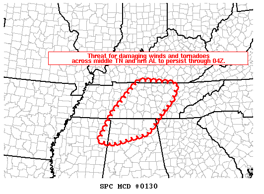
MESOSCALE DISCUSSION 0130
NWS STORM PREDICTION CENTER NORMAN OK
0801 PM CST THU FEB 20 2014
AREAS AFFECTED…MIDDLE TN INTO PARTS OF ERN TN AND NRN AL
CONCERNING…TORNADO WATCH 11…16…
VALID 210201Z – 210330Z
THE SEVERE WEATHER THREAT FOR TORNADO WATCH 11…16…CONTINUES.
SUMMARY…IN ADDITION TO A TORNADO THREAT…CONCERN EXISTS FOR
WIDESPREAD DAMAGING WINDS TO AFFECT MUCH OF MIDDLE TN THROUGH
04Z…AND A SIMILAR THREAT SWD FROM NERN MS INTO NRN AL.
DISCUSSION…AT 0145Z…REGIONAL RADAR IMAGERY SHOWED A QLCS OVER
MIDDLE TN WITH A PORTION OF THIS ACTIVITY APPROACHING THE NASHVILLE
METRO AREA AROUND 02Z…WITH THE MIDDLE TN AND NERN MS PORTIONS OF
THE ACTIVITY REACHING THE ERN EXTENT OF WW 16 IN ERN TN BY 04Z AS
THESE LINES MOVE ENEWD AT 50 KT. DESPITE TIME OF DAY…SLY LOW
LEVEL FLOW HAS MAINTAINED A MOIST-MARGINALLY UNSTABLE ENVIRONMENT…
WHILE RECENT WSR-88D BNA VAD SHOWED VERY STRONG DEEP LAYER WIND
FIELDS SUPPORTING A THREAT FOR DAMAGING WINDS AND A TORNADO THREAT.
TRENDS IN RADAR IMAGERY AND LIGHTNING DATA SUGGESTED AN INCREASE IN
STORM ORGANIZATION AND MESOSCALE ENHANCEMENT PER COLD POOL
EVOLUTIONS.
Category: Alabama's Weather, Severe Weather
About the Author (Author Profile)
Bill Murray is the President of The Weather Factory. He is the site's official weather historian and a weekend forecaster. He also anchors the site's severe weather coverage. Bill Murray is the proud holder of National Weather Association Digital Seal #0001 @wxhistorianSubscribe
If you enjoyed this article, subscribe to receive more just like it.


