

Severe Thunderstorm Warning Marion County until 9 PM

UPDATE: Marion County 911 is reporting a large pine tree is down on AL Hwy 19 near the intersection of county hwy 13 near the Shottsville community in the northwestern part of the county.
The line of strong and intense thunderstorms we have been watching all evening is now making its way into west-central Alabama.
A severe storm is now approaching the western portions of the county and will be impacting areas long U.S. 78 & 278 as well as Interstate 22. The towns of Bexar, Hamilton, Hackelberg, Brilliant and Windfield are in the path of this storm.
Damaging straight-line winds, hail, and very heavy rainfall are possible with this storm as it moves to the east.
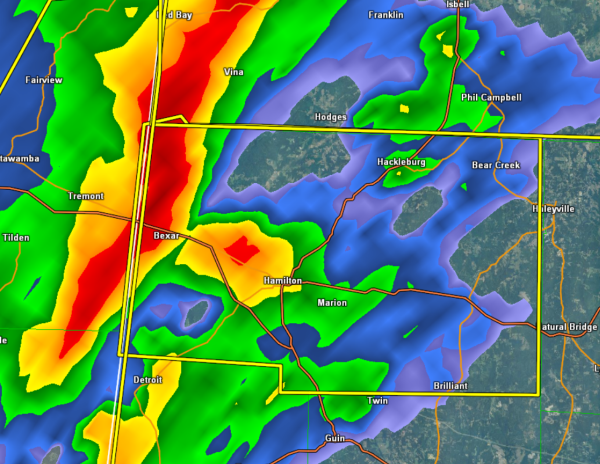
THE NATIONAL WEATHER SERVICE IN BIRMINGHAM HAS ISSUED A
* SEVERE THUNDERSTORM WARNING FOR…
MARION COUNTY IN NORTHWEST ALABAMA…
* UNTIL 900 PM CST
* AT 816 PM CST…THE NATIONAL WEATHER SERVICE INDICATED A LINE OF
SEVERE THUNDERSTORMS CAPABLE OF PRODUCING QUARTER SIZE HAIL…AND
DAMAGING WINDS IN EXCESS OF 60 MPH. THESE STORMS WERE LOCATED
ALONG A LINE EXTENDING FROM 7 MILES SOUTH OF RED BAY TO 6 MILES
EAST OF TREMONT TO 7 MILES NORTHWEST OF DETROIT…AND MOVING EAST
AT 45 MPH.
* LOCATIONS IMPACTED INCLUDE…
HAMILTON…WESTON…HACKLEBURG…BRINN…LAKE BUTTAHATCHEE…
BYRD…PIGEYE AND RANKIN FITE AIRPORT.
THIS INCLUDES…
US 78 EXIT NUMBERS 3 THROUGH 22…
PRECAUTIONARY/PREPAREDNESS ACTIONS…
A TORNADO WATCH REMAINS IN EFFECT FOR THE WARNED AREA. TORNADOES CAN
DEVELOP QUICKLY FROM SEVERE THUNDERSTORMS. ALTHOUGH NOT IMMEDIATELY
LIKELY…IF A TORNADO IS SPOTTED…ACT QUICKLY AND MOVE TO A PLACE OF
SAFETY INSIDE A STURDY STRUCTURE…SUCH AS A BASEMENT OR SMALL
INTERIOR ROOM.
Category: Alabama's Weather, Severe Weather
About the Author (Author Profile)
Subscribe
If you enjoyed this article, subscribe to receive more just like it.


