

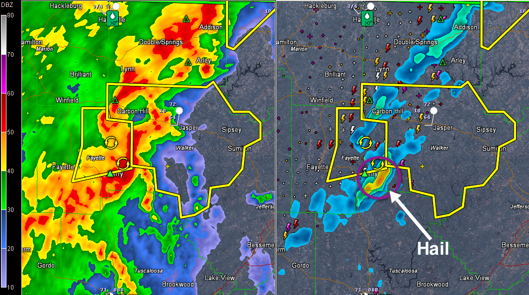
Severe Thunderstorm Warning for Walker til 10:45 p.m.

Dangerous storms are curving around from south of Carbon Hill to east of Berry, where large hail was reported.
It is moving east northeast. Will impact Jasper before 10:25 with hail and high winds.
Be in a safe place as these dangerous storms approach.
THE NATIONAL WEATHER SERVICE IN BIRMINGHAM HAS ISSUED A
* SEVERE THUNDERSTORM WARNING FOR…
WALKER COUNTY IN ALABAMA…
* UNTIL 1045 PM CST
* AT 1007 PM CST…THE NATIONAL WEATHER SERVICE INDICATED A LINE OF
SEVERE THUNDERSTORMS CAPABLE OF PRODUCING QUARTER SIZE HAIL…AND
DAMAGING WINDS IN EXCESS OF 60 MPH. THESE STORMS WERE LOCATED
ALONG A LINE EXTENDING FROM KANSAS TO 6 MILES NORTHWEST OF OAKMAN
TO BOLEY SPRINGS…AND MOVING EAST AT 45 MPH.
* LOCATIONS IMPACTED INCLUDE…
CARBON HILL…JASPER…CORDOVA…DORA…SUMITON…OAKMAN…NAUVOO
AND PARRISH.
THIS INCLUDES…
US 78 EXIT NUMBERS 39 THROUGH 78…
Category: Alabama's Weather, Severe Weather
About the Author (Author Profile)
Subscribe
If you enjoyed this article, subscribe to receive more just like it.


