

Early Morning Update
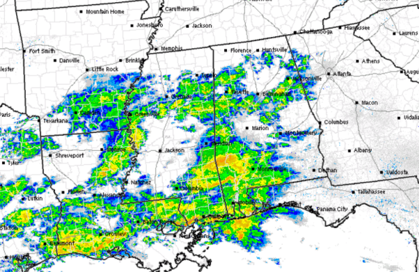
Showers and few thunderstorms continue to move into Alabama tonight. Most locations will see a soaking rain the next few hours before this system moves out of the area. Radar has really started to fill-in this morning and it will continue to do so. Moderate rain is falling across portions of Pickens, Tuscaloosa, Bibb, Shelby, Clay, and Tallapoosa counties. Looking to our west, there is a lot more precip that will be moving in and falling across the state.
For areas off to the southwest, heavy rain and thunderstorms are being reported for area along the Gulf Coast, where even a flash flood warning is currently in effect from Slidell, Louisiana east to nearly Mobile.
A few reports of sleet mixing in across northern Mississippi, but nothing significant being reported.
Now to those ever important temperatures. Many areas remain well above freezing this morning, but temps will be dropping the next few hours. We will have some evaporative cooling as well as cold air advection that will be affecting temperatures the next several hours. Most locations are around the 40 degree mark in North-Central Alabama, but we beginning to see some 30s show up in some areas. Sub-freezing temps are just across the Tennessee border as well, and those will continue to move south.
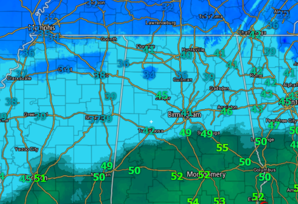
For the next few hours, we should continue to see a cold rain fall across the state, with perhaps a bit of sleet mixing in at times. Closer to daybreak, as colder air continues to filter in from the north, this is when we expect the chance to see more of a widespread threat from a wintry mix.
Category: Alabama's Weather, Winter Weather
About the Author (Author Profile)
Macon, Georgia Television Chief Meteorologist, Birmingham native, and long time Contributor on AlabamaWX. Stormchaser. I did not choose Weather, it chose Me. College Football Fanatic. @Ryan_StinnetSubscribe
If you enjoyed this article, subscribe to receive more just like it.


