Storms Into Alabama By Friday
An all new edition of the ABC 33/40 Weather Xtreme video is available in the player on the right sidebar of the blog. You can subscribe to the Weather Xtreme video on iTunes by clicking here.
THIS AFTERNOON: Temperatures are mostly in the mid to upper 70s across Alabama this afternoon with a mix of sun and clouds. Nothing show up on radar; closest rain is over far West Mississippi.
To the west, strong to severe storms should develop this evening over parts of Oklahoma and Arkansas, but all of that action will remain west of Alabama. However, a few showers could pop up in scattered spots tonight as moisture levels rise.
TOMORROW: Our weather will remain mostly dry with only isolated showers; the big issues will be west of the state, where SPC continues an enhanced “moderate risk” of severe weather for much of Arkansas, Southeast Missouri, and West Tennessee and Northwest Mississippi…
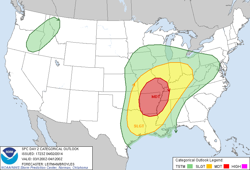
Within the moderate risk area, all modes of severe weather are possible tomorrow afternoon and tomorrow night, including tornadoes. Then, late tomorrow night, the storms should roll over into a long squall line.
FRIDAY: The high resolution NAM now shows the line of strong to severe storms moving into the northwest corner of Alabama around 4:00-5:00 am. Friday with potential for high winds along the line. The primary severe weather threat will remain over the northwest part of the state early Friday morning, including counties like Lauderdale, Colbert, Franklin, Marion, Winston, Lawrence, and Limestone.
The line of storms should slowly weaken and fizzle out as it moves deeper into Alabama during the day Friday. With the main dynamic support well to the north, weakening wind fields, and little shear, I would suggest the severe weather threat for North-Central Alabama is pretty low Friday, but we do note SPC has opted to include much of Alabama in a “slight risk”. The core severe weather threat during the daytime hours Friday should be north of Alabama.
OUR WEEKEND: Saturday looks nice with a good supply of sunshine and a high around 70 degrees. But, clouds and rain will return quickly Sunday afternoon as a surface low forms on the Louisiana coast. Rain becomes widespread, and potentially heavy at times, Sunday night into early Monday morning.
Unfortunately the GFS is now trending toward the European solution, showing the surface low north of Memphis early Monday. This puts all of Alabama in the warm sector, and we are seeing very significant low level bulk shear values. For now the instability looks marginal, but we will clearly need to monitor this system for severe weather potential Sunday night into early Monday morning. Take some time to see the Weather Xtreme video for the maps, graphics, and more details.
LATE SEASON FROST/FREEZE LATE NEXT WEEK? Still getting strong signals from the global models that a long wave upper trough will set up over the eastern third of the U.S. by mid-week, setting the potential for a late season frost, and possibly a freeze by early Thursday morning. Growers will need to monitor this as we get closer to the event.
AT THE BEACH: Dry through tomorrow along the Gulf Coast from Panama City west to Gulf Shores; about 6-8 hours of sunshine both days with highs in the 60s along the immediate coast, with 70s inland. Showers and storms are likely Friday through the weekend; there is potential for heavy rain Sunday and Sunday night along with strong storms. Next week will be drier. Sea water temperatures are generally in the low 60s.
NEED HELP WITH YOUR WEATHER RADIO: We will be at Academy Sports on US Highway 11 in Trussville today from 3:30 until 6:30 p.m. If you need your radio programmed, or have questions, come see us.
WEATHER BRAINS: Don’t forget you can listen to our weekly 90 minute netcast anytime on the web, or on iTunes. This is the show all about weather featuring many familiar voices, including our meteorologists here at ABC 33/40. We will produce this week’s show tonight at 8:30 CT… you can watch it on “James Spann 24/7” on cable systems around the state, or on the web here.
CONNECT: You can find me on all of the major social networks…
Facebook
Twitter
Google Plus
Instagram
Look for the next Weather Xtreme video here by 7:00 a.m. tomorrow….
Category: Alabama's Weather
About the Author (Author Profile)
James Spann is one of the most recognized and trusted television meteorologists in the industry. He holds the AMS CCM designation and television seals from the AMS and NWA. He is a past winner of the Broadcast Meteorologist of the Year from both professional organizations.Subscribe
If you enjoyed this article, subscribe to receive more just like it.


